TORMENTA EN PINAL DE AMOLES, QUERÉTARO, MÉXICO
🇲🇽 ⛈️
Ayer un vehículo fue arrastrado por la crecida y desbordamiento de un Arroyo en Ahuacatlán de Guadalupe, Pinal de Amoles, tras fuertes lluvias y peligrosas crecidas
Créditos 🎥 Mi Sierra Bonita Facebook
Vía @WeatherMonitors
🌦️ Lluvias en #Mexico hoy:
La imagen satelital muestra nubosidad y precipitaciones con dispersas tormentas en el interior, norte y en la península de #Yucatán durante la tarde y noche de hoy, coincidiendo con lo anticipado.
Severe flash floods have hit Puebla, Mexico, after a powerful storm dumped huge amounts of rain in a short space of time.
Major roads quickly turned into fast-moving rivers, causing damage to buildings and infrastructure. At least one person has been confirmed dead.
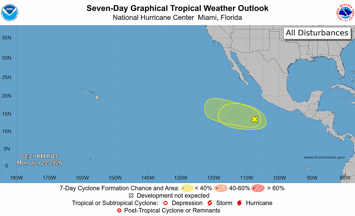
11am PDT 29 June -- NHC continues to monitor a tropical wave in the western part of the East Pacific that now has a high chance (🟠60% 2-day/🔴70% 7-day) of formation later this week.
Latest at https://t.co/y4A78ATRZh
6/27 11am PDT/8am HST: NHC is watching a disturbance located over the central portion of the east Pacific. It has a medium (50%) chance of becoming a tropical depression by the middle of next week. More info: https://t.co/Oy8uoeRKme
This Stone Channel Once Gave Life to an Entire City — Look Closer 👀
Stretching quietly across a green Mediterranean hillside, this ancient stone channel is not just ruins—it’s a lifeline from nearly 2,000 years ago. Built during the Roman era, this aqueduct carried fresh water from distant springs to cities, baths, farms, and homes. Every limestone block was carefully shaped and placed with purpose. Those round holes you see? They weren’t decoration. They were access points, used by engineers to clean sediment, check flow, and keep the water moving smoothly.
What makes this even more fascinating is its simplicity. The channel follows the natural slope of the land, using gravity alone—no pumps, no machines. Just mathematics, patience, and human skill. Standing beside it today feels humbling. Time has worn its edges, but the idea behind it still flows strong. This silent structure reminds us that long before modern technology, people understood nature deeply enough to bend landscapes—not for power, but for survival.
What looks like a river of solid rock is actually a granular flow—a rare and dramatic phenomenon capable of carrying massive boulders with incredible force.
🌧️ #México resto de semana (24–27 jun):
➡️ Lluvias intensas en #Veracruz#Oaxaca#Chiapas por ondas tropicales + alto contenido de humedad
⚡ Chubascos en centro y suroeste.
🔥 Noroeste y sureste con calor >40 °C.
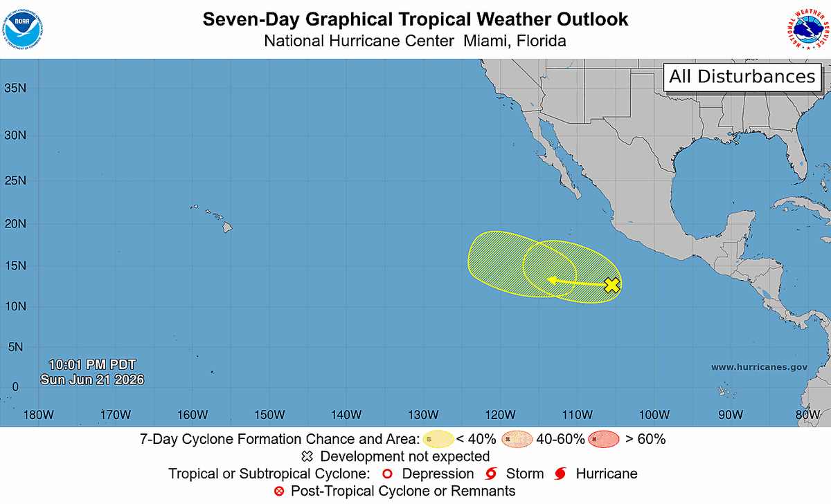
6/22 5 PM PDT: A tropical wave off the coast of Mexico has a low chance of becoming a tropical depression during the next couple of days, and another low may form behind it by the end of week. Neither system poses a threat to land. Check https://t.co/Oy8uoeRKme for more
It is now officially summer in the Northern Hemisphere!
Yesterday's #SummerSolstice marked the start of the season, and this yearlong view of Earth's changing sunlight angle is provided by @NOAA's #GOESEast (#GOES19) 🛰️. Made from images collected daily at 11:50 UTC, this loop shows how our planet's tilt drives the seasons.
6/22 5AM PDT: A tropical wave a few hundred miles off Mexico has a low chance of becoming a tropical depression this week, and another low may form behind it late this week, but neither system poses a threat to land. Check https://t.co/Oy8uoeRKme for the latest information.
4,5 milyar yıl önce başlayan sessiz bir devrim…
Tektonik plakalar çarpıştı, Dünya’nın kabuğu kırıldı ve yükseldi.
Sonuç: Dağlar.
Bu animasyon, bilimin ne kadar görkemli olduğunu bir kez daha gösteriyor. 🌋🏔️
İzleyin, gerçekten etkileyici.
🟥 ⛏️ 🔎 San Andreas Fault isn’t just a line on a map; it’s a 1,200‑km shear zone where two massive tectonic plates grind past each other at roughly 20–35 mm per year.
YT 🎞 Please visit: @Wolficorntv
🔁 ❤️ Greatly Appreciated
That slow motion builds stress unevenly along the fault, creating a patchwork of locked, creeping, and transitional segments.
The northern section last ruptured in 1906 with the great San Francisco earthquake, while the central section near Parkfield slips in small, frequent events that release strain without major quakes.
The southern segment, however, has been locked for more than three centuries, accumulating energy that will eventually be released in a major rupture.
This boundary shapes California’s topography, influences groundwater pathways, and even redirects mountain‑building forces across the state.
It’s a reminder that California’s landscape is not static.
It’s actively being sculpted by deep, ongoing tectonic motion.
#SanAndreasFault
https://t.co/rP1UUfvWt1