...and the latest 8-to-14 Day Precipitation Outlook for November 6th thru November 12th gives Nebraska a "slightly-better-than-average" chance for BELOW NORMAL moisture...
The second-half of that 7-Day showed highs in the 60s...and the latest 8-to-14 Day Temperature Outlook indicates a very good chance that ABOVE NORMAL numbers may continue into mid-November...average highs at the beginning of November are in the mid-to-upper 50s...
The latest 7-Day is basically dry through the period with some fluctuating temperatures...Thursday morning will be very chilly with FREEZE WARNINGS for much of central & eastern Nebraska...with moderating afternoon temps...cooling off again FRI-SAT...turning milder after that...
The NWS has upgraded to a FREEZE WARNING for parts of central and eastern Nebraska that have yet to see a hard freeze...temperatures in these areas could fall into the mid-to-upper 20s for a period of time late tonight into early Thursday...
Freeze watch for parts of southern and southeastern Nebraska late Wednesday night into early Thursday morning. Freeze warning for parts of southwestern Nebraska. Temperatures expected to drop into the 20s to lower 30s by early Thursday morning.
9pm temperatures on this Tuesday evening continue to fall like a rock in the west where we've got lighter winds and mainly clear skies...it's already in the lower 30s in the far west...clouds and that strong wind helping keep readings "up" for parts of central and eastern NE...
...and here's a reminder that a WIND ADVISORY remains in effect for much of eastern Nebraska...including Lincoln...until 7am Wednesday morning...winds in this area "could" gust between 40-and-50 mph at times...batten down the hatches...
At 9:15pm Tuesday in Lincoln...the northwest winds have increased...sustained at 24 mph, gusting to 37 mph...skies remain mostly cloudy and temperatures are holding fairly steady in the upper 40s...but when you factor in that wind, it "feels like" 41°...winds continue overnight.
The Lincoln Weather Almanac for today includes a high of 52° and a low so far of 47°...the airport picked up 0.31"of rain...and sunset tonight is at 6:28pm...remember that this weekend is the end of Daylight Saving Time, so set your clocks BACK 1 hour Saturday night...
...and with that in mind...the National Weather Service has issued a WIND ADVISORY for parts of eastern Nebraska and eastern Kansas...for Nebraska it runs from 7pm Tuesday thru 7am Wednesday for sustained winds of 20-to-35 mph...with possible gusts of 40-to-50 mph...
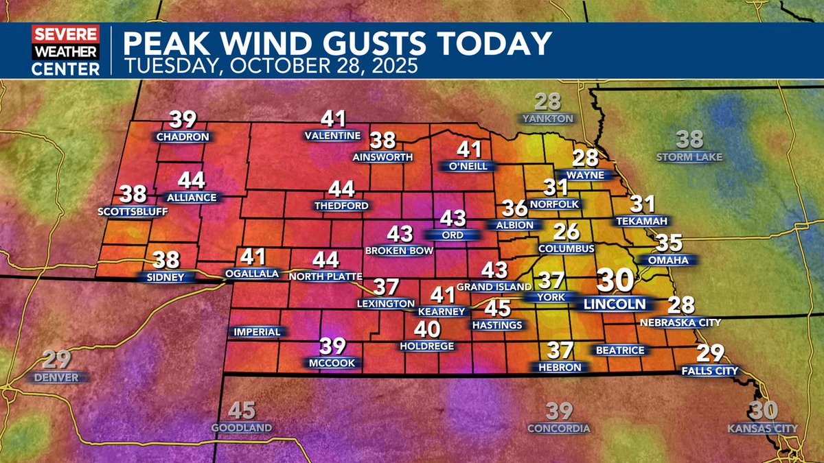
As of 5pm Tuesday...here's a look at the peak wind GUSTS reported so far today...areas of eastern Nebraska are expected to see NW winds gusting between 40-and-50 mph later tonight and into early Wednesday...
Beyond the 7-Day...the latest 8-to-14 Day Temperature Outlook calls for a "much-better-than-average" chance for ABOVE NORMAL readings for the entire region, as we head for November 5th thru November 11th...
Our latest 7-Day Outlook includes just one small precipitation chance for Wednesday morning...with mainly dry conditions then expected for the rest of the next week...seasonably cool temperatures are likely for the rest of this week, with some warming taking place SUN-MON-TUE...
The latest 8-to-14 Day Precipitation Outlook for the 4th thru the 10th gives most of Nebraska a "slightly-better-than-average" chance for BELOW NORMAL moisture...so if you're hoping for rain...Tuesday-Wednesday may be your best bet over the next couple of weeks...
The latest 8-to-14 Day Temp Outlook is still quite "bullish" on the chances for ABOVE NORMAL readings across our area beyond our latest 7-Day...by the beginning of November our averages drop to the upper 50s for highs...and the lower 30s for lows...the period is Nov 4 - Nov 10th.