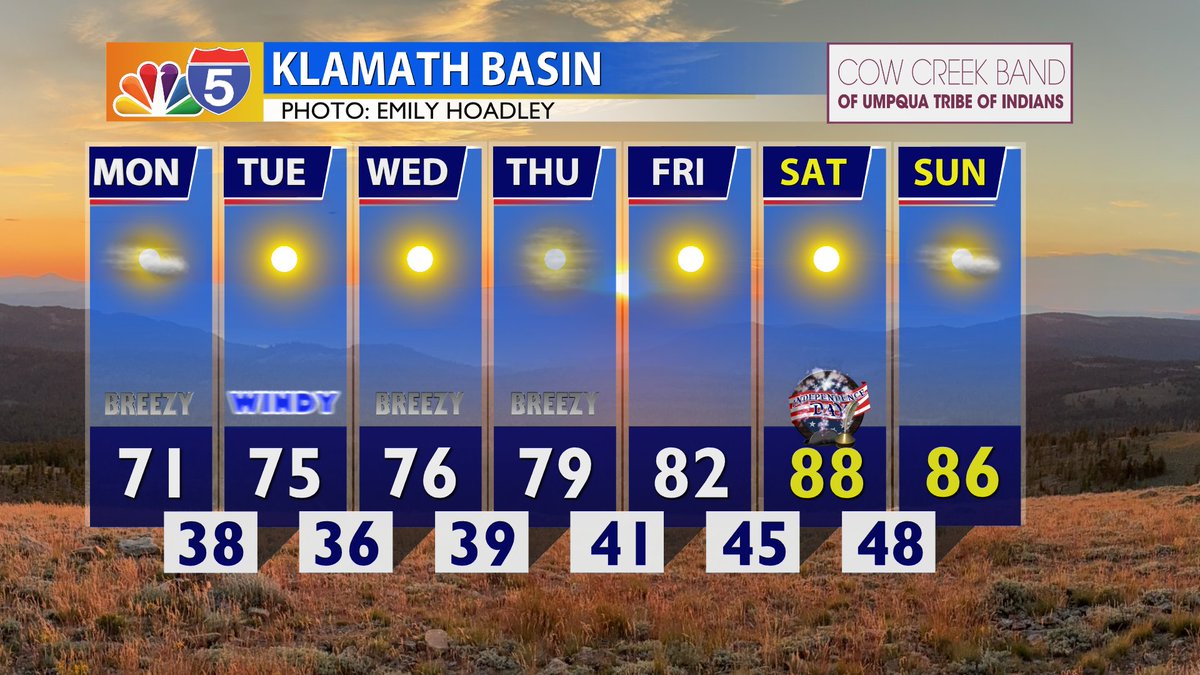
We are done with the rain, but the below seasonal highs and slightly breezy days are expected to last for most of this week. Getting toasty with plenty of sunshine this July 4th weekend. Enjoy! @KOBITV
Unseasonably mild temperatures continue for the next couple of days, with very minimal weather impacts expected.
Warmer temperatures in the high 80s, low 90s return for the 4th of July weekend.
Mild temps are here to stay for most of the week.
A cold front pushes in near Thursday that could bring another round of light rain showers to the area.
Fourth of July is looking to be dry, sunny, and warm with a high near 88 for the Rogue Valley.
According to ACCESS, the demand for food assistance often increases during the summer months when children no longer have access to school meal programs.
https://t.co/58d1YxA6Df
Shower activity is expected to stick around through early Sunday. Does this mean it will rain all weekend? No. There will be periods of dry conditions. The bigger difference is our cooler highs and chillier mornings. Our eastern counties may develop frost starting Sunday. @KOBITV
3:40a - I got a free car wash driving into work this morning with rain covering our area. This is the best chances for rain today as this afternoon will bring spottier showers inland with scattered coastal showers. Join @KOBITV starting at 5:30a for the latest updates.
Today brings back average highs, breezy west winds, and increasing clouds. Increasing showers overnight tonight through early Sunday, though we will take any precipitation, amounts won't be all that impressive. Another big change will be the cooler days ahead. @KOBITV
Another hot, dry, and slightly breezy day to keep up our fire danger levels. Thankfully, cooler days are upon us, then we will be getting into rain chances starting as early as Thursday night. Plan accordingly if you have any outdoor plans this weekend. @KOBITV
Hotter temperatures ease around late week as a front passes through Thursday night into Friday, bringing a chance for light showers next weekend.
At this time, rain chances are slim for east of the Cascades and northern California.
The west valleys will be very hot Monday and Tuesday with many areas just shy of triple digits.
Adequate hydration and access to air conditioning will be extremely important.
A warming trend continues through early next week, with the area largely staying sunny, hot, and dry.
Next weekend brings some relief with slightly cooler temperatures and a slight chance of showers.
Isolated thunderstorms popping up this afternoon in Siskiyou, Modoc, and Lake counties are expected to east into the nighttime.
Sunday (Father's Day and Summer Solstice!) is expected to be sunny and hot, with a warming trend continuing through early next week.
Today brings rain and storms for some in our area with abundant lightning on dry vegetation. A Red Flag Warning has been issued due to the risk of new fires starting and spreading very quickly. @BobbyJohnstonWX has the latest in this morning's update. https://t.co/sMkw6S6i0y
Another hot day but includes a low chance for isolated storms in our southeastern areas. Friday will be more active in storm activity especially in NorCal and our eastern counties. Any storm brings the risk of lightning on dry vegetation to start and spread fires quickly. @KOBITV