The eye of a hurricane: Exceptionally low pressure at the center powers the violence around it, but the eye itself is calm. The eye of Melissa is as textbook as you can get. Beautiful, deep stadium effect. Pure calm. But unimaginable violence awaits in the perimeter (eyewall).
So many stunning images from the 2025 hurricane season, but this pass into Category 5 Melissa's eye by @53rdWRS Hurricane Hunters on October 27th might be the most breathtaking I've ever seen. (video via @FlynonymousWX)
Post-Tropical Cyclone Isaias is about 80 miles north-northeast of Pensacola Florida. Winds 65 mph. Isaias moving over southern alabama. Flash flooding and strong wind threat spreads farther inland. A motion toward the north-northeast or northeast is forecast on Sunday.
Flash Flood Warning remains in effect for Santa Rosa, FL until 2:00 AM 10/10/26. Flash flooding from thunderstorms is ongoing; 4-7 in rain already fell. Turn around, don’t drown—avoid flooded roads.
Flash Flood Warning remains in effect for Santa Rosa, FL until 1:15 AM 10/10/26. Flash flooding is ongoing with 5-7 in rain; flooding of roads, underpasses, and low areas. Turn around, don’t drown.
Flood Warning for Okaloosa and Santa Rosa Counties until 8:00 AM 10/10/26. Flooding from excessive rainfall is occurring with 6-12" of rain. Turn around, don’t drown—avoid driving on flooded roads.
Hurricane Isaias is about 45 miles east-northeast of Pensacola Florida. Winds 90 mph. Isaias moving over the western florida panhandle. Damaging winds and flash flooding threat spreads inland. A motion toward the north-northeast or northeast is forecast on Sunday.
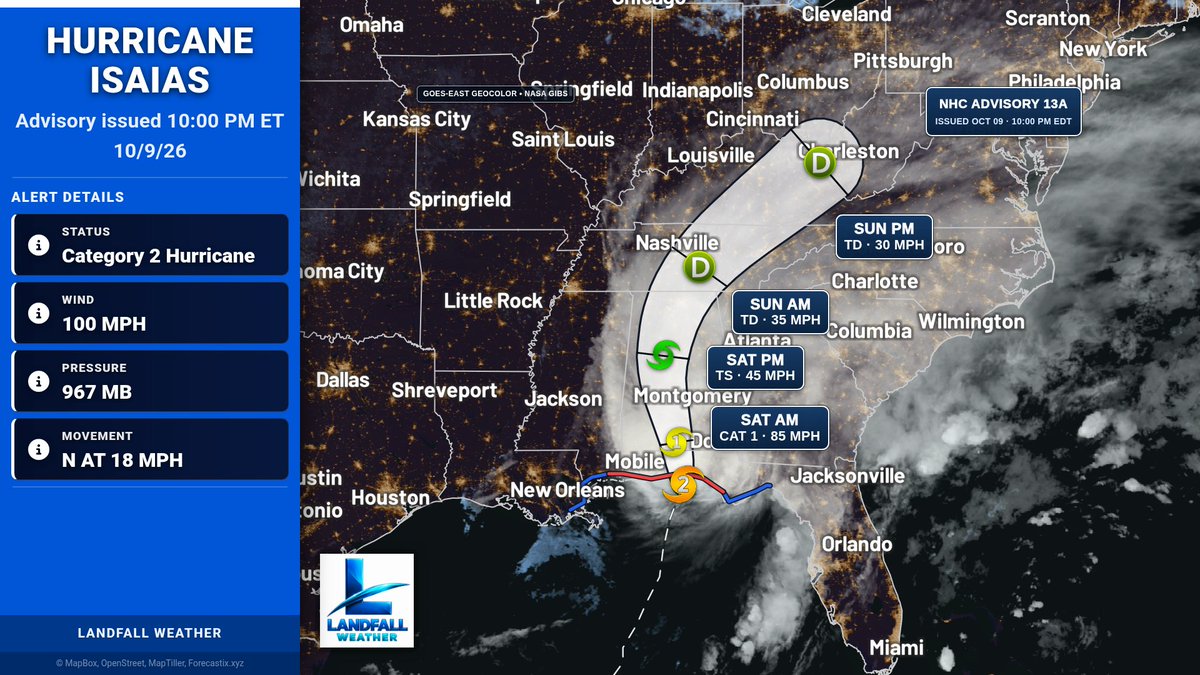
Hurricane Isaias is about 50 miles east of Pensacola Florida. Winds 100 mph. Life-threatening storm surge impacting the Gulf Coast as dangerous hurricane conditions and flash flooding spread inland. 900 pm cdt position update. Moving north at 18 mph. As of Oct 09 at 10:00 PM EDT.
Hurricane Isaias is about 50 miles east of Pensacola Florida. Winds 85 mph. Life-threatening storm surge impacting the Gulf Coast as dangerous hurricane conditions and flash flooding spread inland. 900 pm cdt position update. Moving north at 18 mph. As of Oct 09 at 10:00 PM EDT.
Hurricane Isaias is about 50 miles east of Pensacola Florida. Winds 85 mph. Life-threatening storm surge impacting the Gulf Coast as dangerous hurricane conditions and flash flooding spread inland. 900 pm cdt position update. Moving north at 18 mph. As of Oct 09 at 10:00 PM EDT.
Flash Flood Warning for Holmes and Walton Counties, FL until 12:30 AM 10/10/26. Life-threatening flash flooding from heavy rain is ongoing. Turn around, don’t drown—move to higher ground now.
Flash Flood Warning remains in effect for Okaloosa and Santa Rosa Counties, FL until 1:30 AM 10/10/26. Life-threatening flash flooding from heavy rain is ongoing. 3-5" already; 2-3"/hr possible. Turn around, don’t drown.
Flash Flood Warning for Santa Rosa County, FL until 2:00 AM 10/10/26. Life-threatening flash flooding from heavy rain is ongoing; 2-3"/hr possible. Turn around, don’t drown—avoid flooded roads.
Flash Flood Warning for Holmes and Walton Counties, FL until 11:30 PM 10/9/26. Life-threatening flash flooding from thunderstorms with heavy rain is ongoing. Turn around, don’t drown—move to higher ground now.
Flash Flood Warning for Okaloosa and Santa Rosa Counties, FL until 1:30 AM CDT. 1-3 in/hr rain with flash flooding ongoing. Turn around, don’t drown—avoid flooded roads.
Flash Flood Warning for Santa Rosa County, FL until 1:15 AM 10/10/26. Life-threatening flash flooding from thunderstorms with 2-3 in/hr rain. Turn around, don’t drown—do not drive on flooded roads.
Flash Flood Warning for Okaloosa, FL until 1:15 AM 10/10/26. Life-threatening flash flooding with 3-5 in/hr possible. Heavy rain is ongoing near Wright, Fort Walton Beach, and Destin. Move to higher ground now.
Hurricane Isaias is about 45 miles southeast of Pensacola Florida. Winds 110 mph. Isaias nearing landfall in the western florida panhandle. Hurricane conditions with extreme wind gusts spreading across the warning area. Moving north at 18 mph. As of Oct 09 at 8:00 PM EDT.
Flash Flood Warning for Walton County, FL until 1:30 AM 10/10/26. Flash flooding from thunderstorms is ongoing/expected. Heavy rain may flood small creeks/streams, roads, and underpasses. Turn around, don’t drown.
Flash Flood Warning for Escambia, FL until 12:15 AM 10/10/26. Heavy rain is causing flash flooding; 2-4 in more possible. Flash flooding of roads, underpasses, and low areas. Turn around, don’t drown.
Hurricane Isaias is about 55 miles south-southeast of Pensacola Florida. Winds 115 mph. Extreme wind warning issued for portions of the western florida panhandle. Eyewall of Isaias approaching the coast. Moving north at 17 mph. As of Oct 09 at 7:00 PM EDT.