Remember this? I meant to post yesterday, but Tropical Storm Allison was moving across southeast Louisiana 25 years ago -- June 11, 2001. Days of persistent heavy rain produced significant flooding, including on area rivers. Rain totals of 15"-20" were common, with nearly 30" reported in Thibodaux!
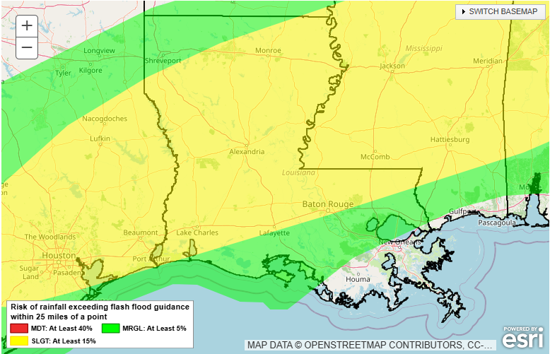
There is the potential for heavy rainfall next week in Louisiana. Some areas may receive as much or more than one month's worth of rainfall (approx. 5.00"-5.50") in a matter of days. At least some part of the state is at risk for excessive rainfall on Sun., Mon., and Tues.
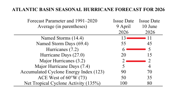
The team from Colorado State released their updated 2026 Atlantic basin hurricane season forecast, lowering the number of anticipated named storms from 13 to 11 and the number of anticipated hurricanes from 6 to 5. For the full forecast, visit: https://t.co/qLyDZ7g9lN
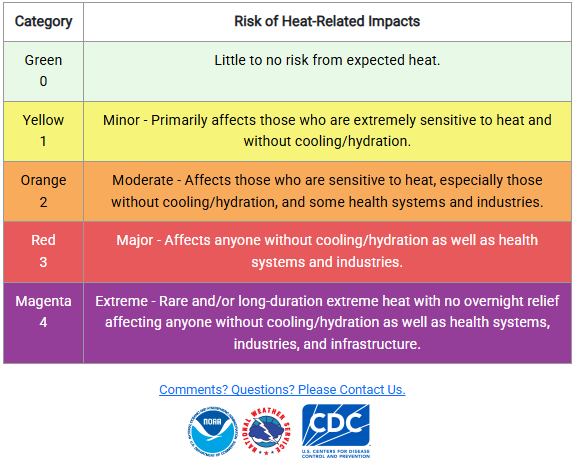
The heat continues to build across the Bayou state and today will be no exception. 'Apparent' temperatures by the mid and late afternoon will be approaching and exceeding 100 degrees across most of the state. Be sure to stay hydrated!
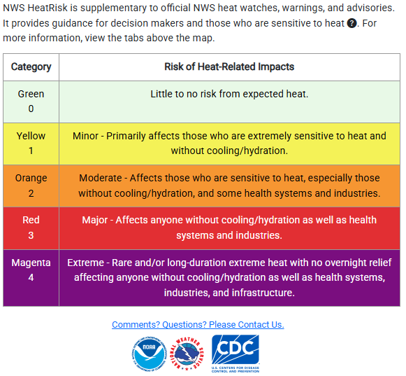
As we spoke of yesterday, the heat will be building across Louisiana this week. According to the NWS HeatRisk map, 'major' impacts are expected today across central and northern Louisiana. Impacts are expected to increase as the week moves along.
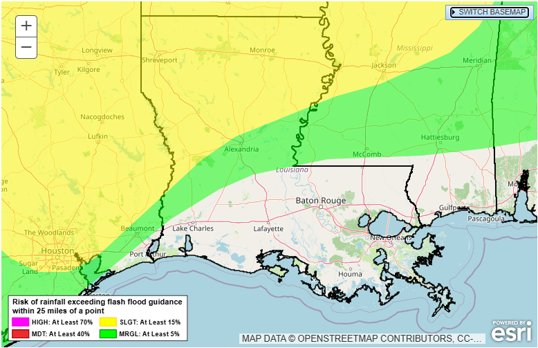
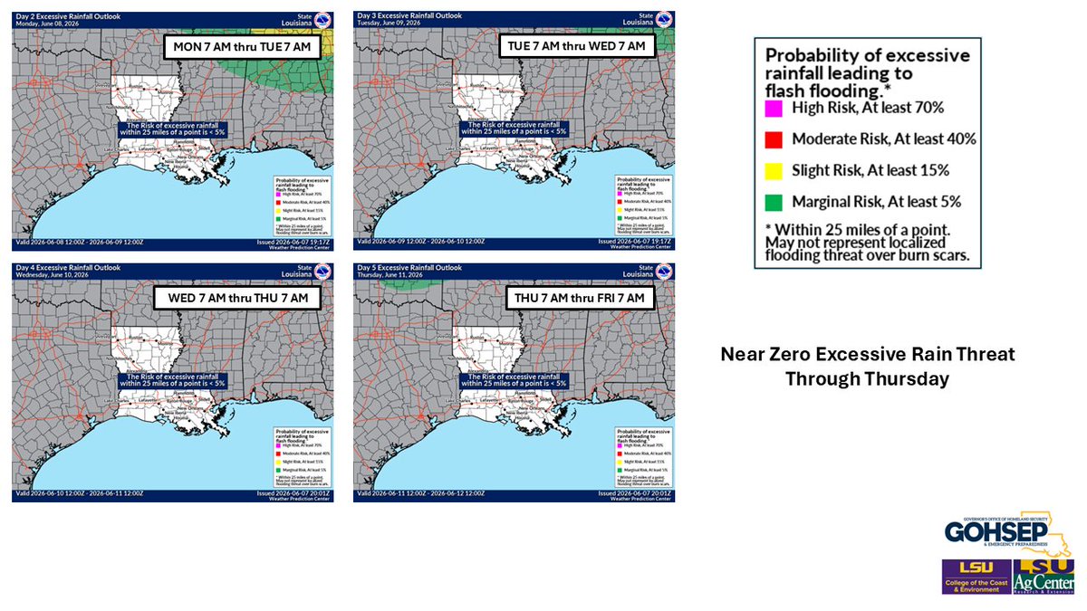
Louisiana summer heat will be building in this week with temperatures approaching the mid-90s in the northern half of the state around mid-week. While it won't be completely rain-free, it's looking to be a drier week with no flash flood or severe weather concerns.
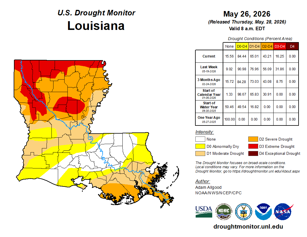
How does the current drought in Louisiana compare to others back to 2000? According to the USDM, the current drought hasn't been as intense as 2023 or as long as the 2010-2012 drought. However, each drought is different and impacts depend on duration, intensity, and timing.
This week's U.S. Drought Monitor depiction showed more improvement across Louisiana. Coverage of D3 ('Extreme') drought is at its lowest since late-February. Total drought coverage is at its lowest since late-January.
While there is some slightly drier air across Louisiana this morning in the wake of a rare June frontal passage, don't expect it to last long. The mean dew point temperature (1991-2020) is 67-71 deg F across central and northern Louisiana and 71-75 deg F in southern Louisiana.
May was certainly a wet month across most of Louisiana. Many areas in southern Louisiana received over a foot of rain, which was 8.00"+ above 30-day normals. Only portions of northwestern Louisiana received rain amounts below 30-day normals.
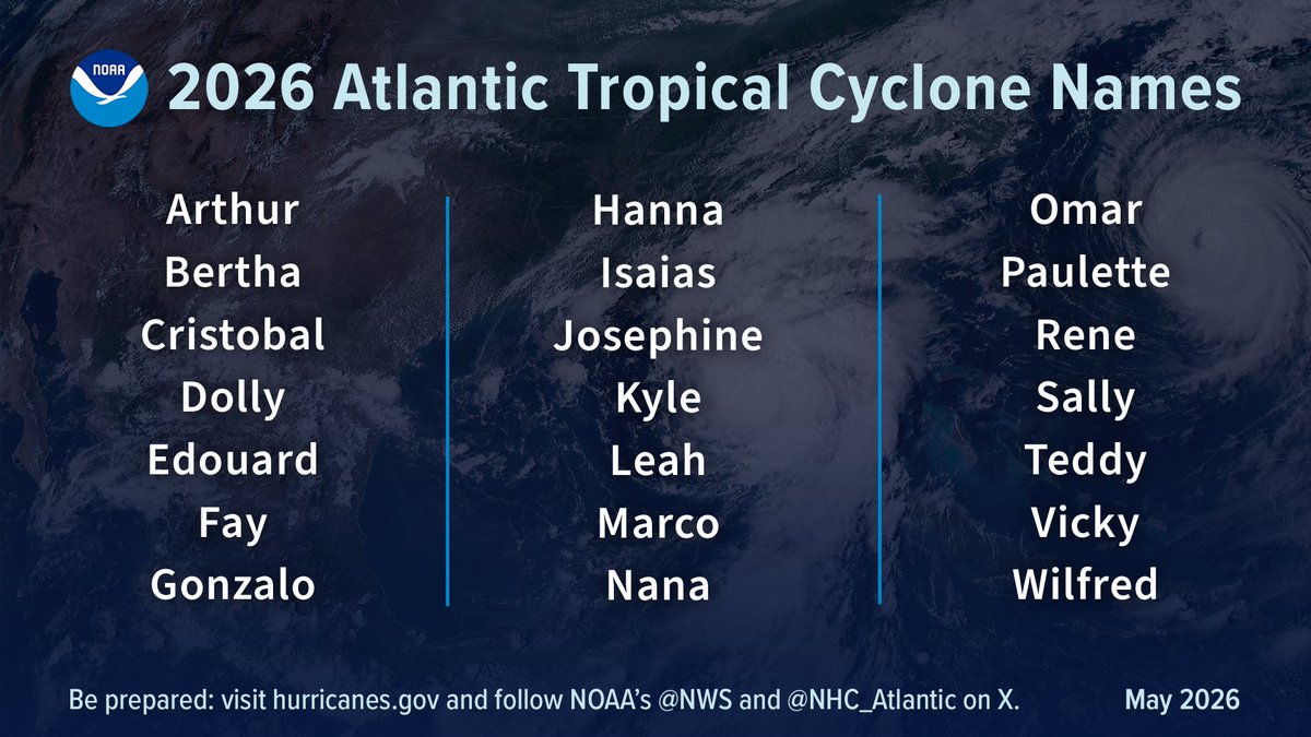
Today is the official start of the 2026 Atlantic basin hurricane season! Although we are months away from the peak of the season and forecasts are for a below-normal number of storms, now is the time to prepare so you are ready should a storm approach your area.
Potential heat impacts will increase this weekend as temperatures rise and rain chances fall. 'Major' impacts are expected for portions of central and northern Louisiana on Sunday. Take particular caution this weekend as you may not yet be re-acclimated to the heat/humidity.
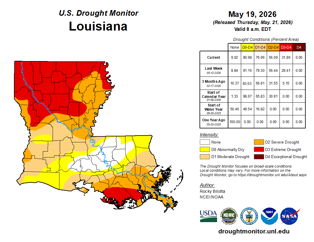
The new U.S. Drought Monitor depiction was released today and more rain meant more improvements for Louisiana. Almost 2/3rds of the state remains in some form of drought; however, that's lower than the 3/4ths coverage last week.
Now that we are almost through May, what is June looking like? According to the Climate Prediction Center, June is unfortunately looking to be warmer than normal for Louisiana. The precipitation trend is less defined with mostly equal chances of above or below-normal precip.
NOAA released their 2026 Atlantic hurricane season outlook yesterday and chances are trending towards a below-normal season. The yearly average is 14 named storms, 7 hurricanes, and 3 majors. NOAA's outlook calls for 8-14, 3-6, and 1-3, respectively. Remember, it only takes one.
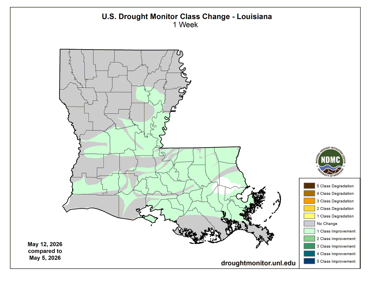
The new U.S. Drought Monitor was released today and it was a mix of improvements across southern Louisiana and degradations across northern Louisiana (data cutoff was Tuesday at 7AM). With current and forecast rains, improvements will be likely next week.
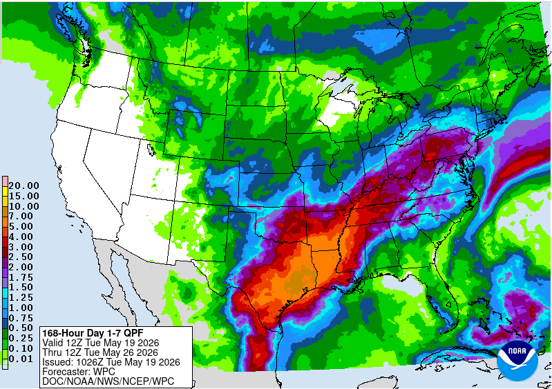
Much of the state got wet yesterday and more is in store the next few days. It is possible that there will be widespread amounts exceeding 5.00" between now and next Wednesday morning (a month's worth of rain). The good news is severe weather doesn't look to be a big factor.
Remember when it seemed like we couldn't buy a drop of rain? Well, it's possible that some portions of Louisiana could receive several inches over the next few days. Have the umbrellas handy!
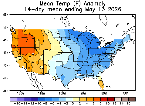
How is it already halfway through May? So far, it has been a good month for putting a dent in drought. Much of central and southern Louisiana are in excess of 3.00" above 14-day normal precipitation and temperatures have been 2-6 degrees F below 14-day normals across the state.
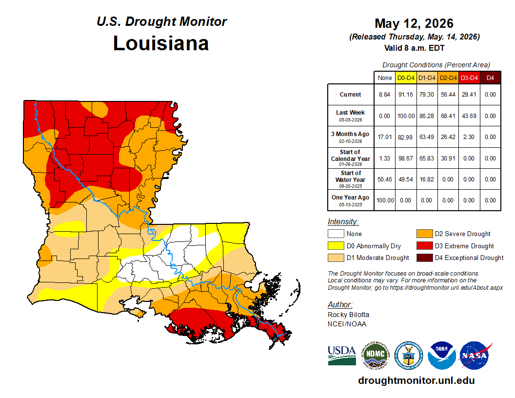
After the rains of the past few days, the new U.S. Drought Monitor released today showed significant improvements across the state, particularly in central and southern Louisiana. There is more good news as conditions look to remain wet the next two weeks.