One of Ireland's leaders in Geographic Information Science. Providing complete data control for government & industry! 🛰🌍 #Geospatial#GIS#EarthObservation
We've wrapped up our 30th anniversary celebrations! A big thank you to all our amazing colleagues for making it so special! 🎉
Here's a quick look back at the highlights 🎥
#30YearsTogether#Mallon#TeamCelebration
✨ 𝐖𝐢𝐬𝐡𝐢𝐧𝐠 𝐲𝐨𝐮 𝐚 𝐇𝐚𝐩𝐩𝐲 𝐍𝐞𝐰 𝐘𝐞𝐚𝐫 𝐟𝐫𝐨𝐦 𝐞𝐯𝐞𝐫𝐲𝐨𝐧𝐞 𝐚𝐭 𝐌𝐚𝐥𝐥𝐨𝐧
As we look ahead to the year to come, we wish our customers, colleagues, and followers a happy and enjoyable New Year.
Wishing you all a prosperous and fulfilling New Year! 🎆🥳
🎄 𝐌𝐞𝐫𝐫𝐲 𝐂𝐡𝐫𝐢𝐬𝐭𝐦𝐚𝐬 𝐟𝐫𝐨𝐦 𝐚𝐥𝐥 𝐨𝐟 𝐮𝐬 𝐚𝐭 𝐌𝐚𝐥𝐥𝐨𝐧
We hope today brings you time to relax, celebrate and enjoy the festivities.
Wishing all of our customers, partners and followers a very happy and peaceful Christmas. 🎁✨
#MerryChristmas
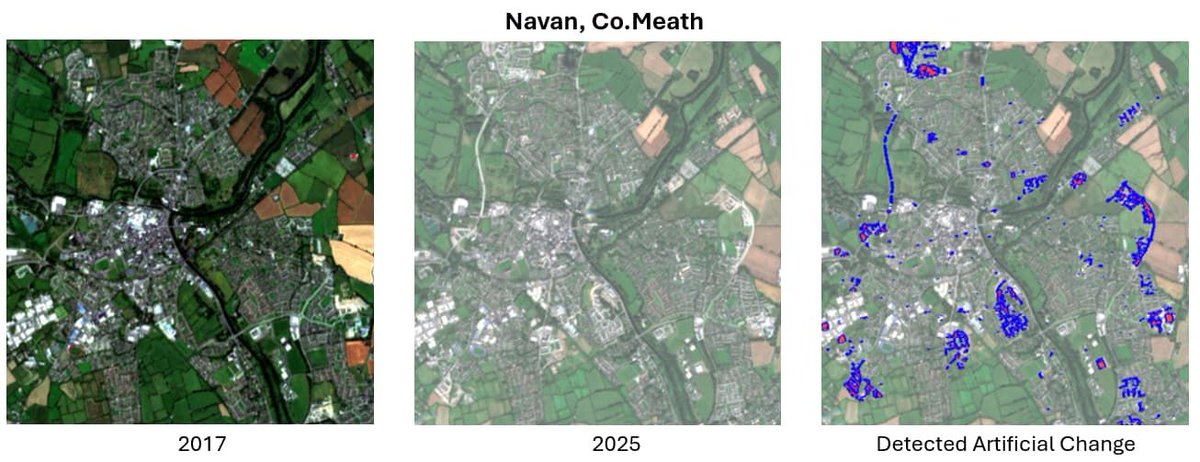
Ireland's towns are growing fast.
Using Sentinel-2 imagery, we analysed land-use change in Navan, Moyculen & Macroom (2017-2025).
Key trends:
🏠 Housing growth
🛣️ New transport routes
🏭 Expanding industry
🌱 Reduced green space
🔗 Read more: https://t.co/nq5iz8diDm
#EO#GIS
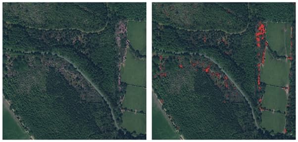
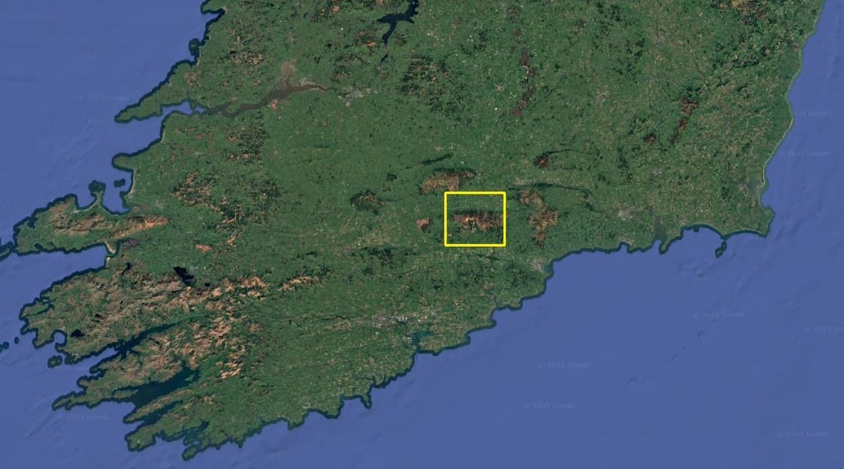
🌍 Tracking Quarry Change from Space
Using Sentinel-2 satellite imagery, we analysed a quarry in Co. Kildare to monitor expansion, vegetation recovery & restoration over time, showing how Earth Observation supports sustainable land management.
🔗 https://t.co/Q1nRRBjfwT
#GIS
We're proud to be finalists for the Sustainability Award at the Mid Ulster Business Awards! 🏆🌿
Being shortlisted is a fantastic acknowledgement of our company's dedication to building a more sustainable future.
Read more: https://t.co/xXNbNyaDkY
#Sustainability#NetZero
🌆Dublin's skyline is changing - but how fast?
Using satellite data & machine learning, we mapped urban growth from 2019-2024. Over 15km² of new development was detected, mostly in the suburbs.
🔗 Read more: https://t.co/7c5gG7jSrj
#EarthObservation#UrbanSprawl#Dublin#GIS
Flooding poses a major risk to Irish towns.
This map of Enniscorthy shows how rising waters threaten homes & infrastructure.
🛰️ Using LiDAR & Remote Sensing, we can pinpoint at-risk properties & support smarter flood planning.
🔗 Read more: https://t.co/JgJCvlWy7I
#EO#LiDAR
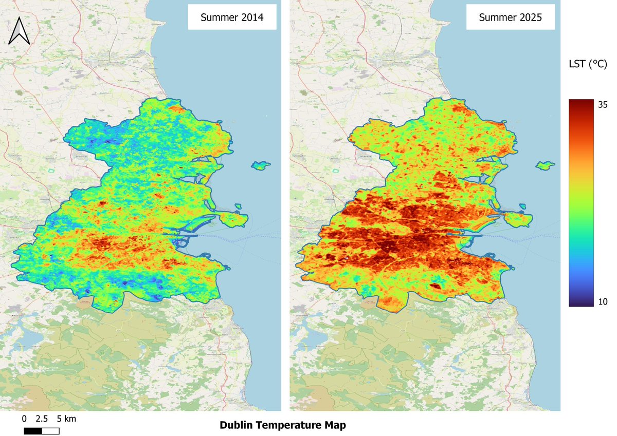
🌆 Dublin & London are heating up.
Using Landsat 8 data, we compared land surface temps from 2014-2025
📈 Dublin: 21.6°C → 26.7°C
📈 London: 26°C → 31.9°C
Read the blog 👉 https://t.co/DvThkW7Eu2
#UrbanHeat#EarthObservation#SmartCities#EO#RemoteSensing
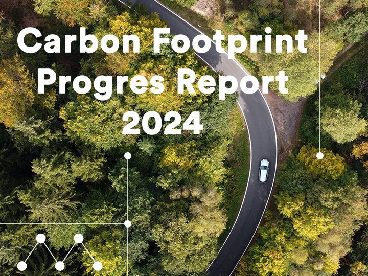
We've published our 2024 Carbon Report 📊
✅ Scope 2 emissions down by 98.7% since 2021
✅ Scope 1 & 2 now just 1% of our total footprint
We're proud of our progress as we continue towards Net Zero by 2040.
Read more: https://t.co/KrgZvzHEUh
#NetZero#Sustainability
According to the CSO, Ireland's gender pay gap is 9.6% in favour of men.
At Mallon, our early 2025 ROI data shows a -𝟓% 𝐠𝐚𝐩 𝐢𝐧 𝐟𝐚𝐯𝐨𝐮𝐫 𝐨𝐟 𝐰𝐨𝐦𝐞𝐧.
We're working for true equity, not just closing the gap.
👉 Read more: https://t.co/3t5dwYtvsb
#GenderPayGap
🚀We're all set and ready to go!
We're excited to be back at the @NI_AGI Annual conference.
Come chat to us about our latest Geospatial and Earth Observation expertise.
#EO#Geospatial#AGINI#Networking#Mallon
🌇 Why are cities like London & Dublin hotter than ever?
Satellites like MODIS reveal how urban design is driving rising temperatures in these cities.
Our new blog explores how satellite data can be used to track urban heat from space.
Read more 👉 https://t.co/IHRfl61aT9
#EO
👏 Big thank you to @MallonTech
for sponsoring #GeoPlace25 Come & meet Mallon Technology, leaders in Geographic Information Science, on Stand No. 16 - https://t.co/uXxTlM3mqM
🗓️22 May | 155 Bishopsgate, London
Register now: https://t.co/RgNz3Vok5u
🚒 We're heading to @CfoaIreland 2025! Catch Mallon at Stand 22 on 7-8 May in Galway. We'll be showcasing Diamond Fire Web + Fire Cert Scanning to support digital transformation in the Fire Service. Come say hi! 👋
#DigitalTransformation#CFOA2025#CFOA#DiamondFireWeb
@MallonTech will be joining @NI_AGI for #AGINI25 "Bridging the Divide: Advancing Geospatial Collaboration and Interoperability"
📅 Thursday 12 June
🕘 09:00-17:00
📍Riddel Hall, Belfast
Call for papers closes in one week! Read more and register🔗https://t.co/bef1jaOqde
🌿 Mapping the Purple Invader from Above 🛰️
Rhododendron Ponticum may be beautiful in bloom, but it's a serious threat to Ireland's native biodiversity. 🌸
Check out our blog to learn how we identified Rhododendron outbreaks with #RemoteSensing. ⬇️
https://t.co/l6dfJLqWoX
John, Catarina, and Jane all had a fantastic time yesterday at Maynooth University, where they delivered an industry presentation to MSc students.
Thank you to everyone who attended.
#Mallon#Careers#Geospatial#GIS#EarthObservation