#Cooler air returns west of the Rockies as June ends, while broader #warmth builds into early July, especially around the #Rockies. #Rainfall stays limited for much of the #Lower48, aside from a few #wetter pockets, with eastern #Kansas particularly dry.
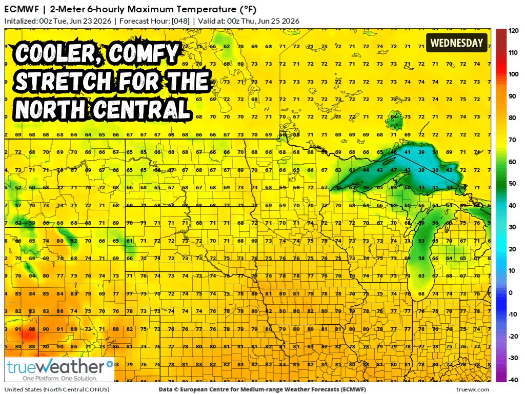
A cooler stretch holds across the #CentralUS and parts of the #Midwest through the end of the work week. Highs in the northern and central Plains should generally run in the 60s and 70s, about 5-10° below normal, with some spots closer to 15° below for late June. #Weather
Soggy start to summer continues for #NewEngland, the #MidAtlantic, and the #Southeast through Tuesday. Most areas could see .5-1.5" of rain, locally 2", with much of it falling through early Tuesday morning. Stronger storms may bring damaging winds and isolated tornadic activity.
We’re closely watching a strengthening system moving from Alberta into the North Central U.S. A #ModerateRisk for #SevereWx is in place Wednesday from central #Illinois into west central #Indiana, with #wind gusts up to 80 mph, #hail over 2", and severe #tornadoes possible.
The latest #DroughtMonitor shows improvement across the #Southeast, with above-normal precipitation continuing through next week. Beneficial #rainfall through next weekend should reduce #drought intensity and coverage before things #dry out the last week of June into early July.
Outdoor #WorldCup watch parties across the #MidAtlantic should monitor the radar later today. Scattered strong to severe #storms may bring winds in excess of 60 mph, but the main threat should pass before the #UnitedStates and Paraguay match begins at 9 PM Eastern time. #SevereWx
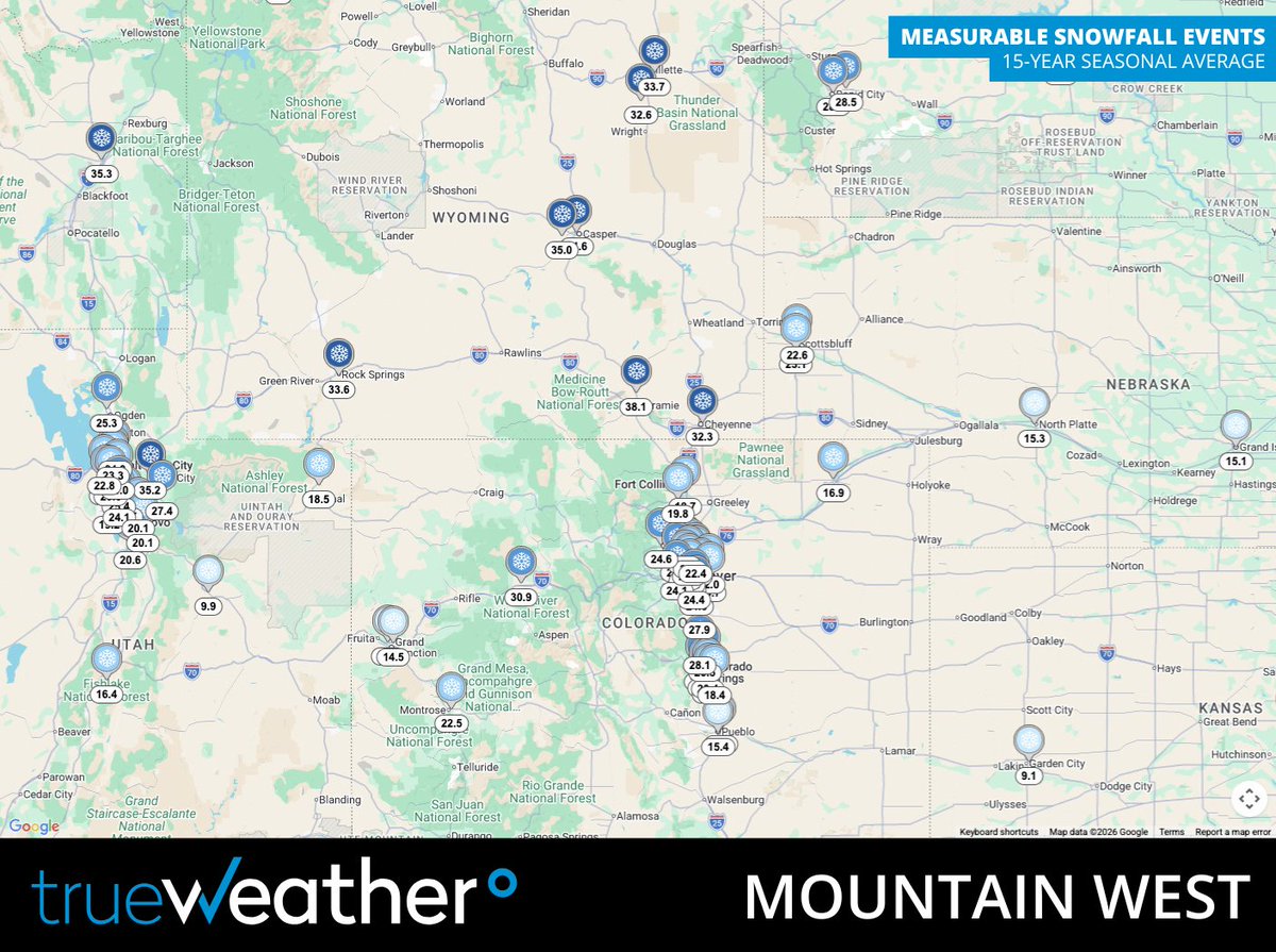
Average seasonal snowfall can be difficult to translate into operational demand. trueWeather’s 15-year Snow & Ice Climatology Reports provide location-specific insight into #MeasurableSnowfall and #ServiceableEvents. Learn more at https://t.co/DQej7pbRx2
#𝗘𝗡𝗘𝗥𝗚𝗬 𝗨𝗣𝗗𝗔��𝗘 - A brief cooldown will bring below-normal temps to the #South Central later this weekend into early next week before readings rebound. Gas-weighted #cooling degree days will run below normal, keeping cooling demand lighter.
#OOTT#NaturalGas#Gas#Oil
After a cooler start to the work week, heat builds north Thursday through Sunday into the #MidAtlantic and #SouthernNewEngland. The #I95Corridor may climb well into the 90s with heat index values near or above 100°F in more urbanized areas before relief arrives late this weekend.
𝙇𝙊𝙉𝙂 𝙍𝘼𝙉𝙂𝙀 𝙊𝙐𝙏𝙇𝙊𝙊𝙆 - Cooler air targets the Upper Midwest and Great Lakes through late June, while warmth holds elsewhere. Wet weather favors the Lower to Mid-Mississippi Valley, while the Pacific Northwest, Cascades, and Central Gulf Coast trend drier.
Severe weather ramps up across the #NorthCentral, starting in the Dakotas, Nebraska, and western #Minnesota on Tuesday before shifting toward eastern Minnesota, Wisconsin, eastern Iowa, and northern Illinois Wednesday into Thursday. The threat moves into the #Northeast late week.
An #AtmosphericRiver will bring heavy #Rain to the #PacificNorthwest, with 1-3" expected and locally higher amounts upwards of 3" expected. #Snow may fall in the highest northern #Cascades and northern #Rockies. In addition, temperatures run 5-15°F below normal through Thursday.
#HeavyRain will raise the risk of #Flooding and #FlashFlooding from the Central Plains into the Tennessee and Ohio Valley and surrounding areas through midweek. #Rainfall totals of 1-2" are expected, with locally higher amounts upwards of 2.5" likely in some areas.
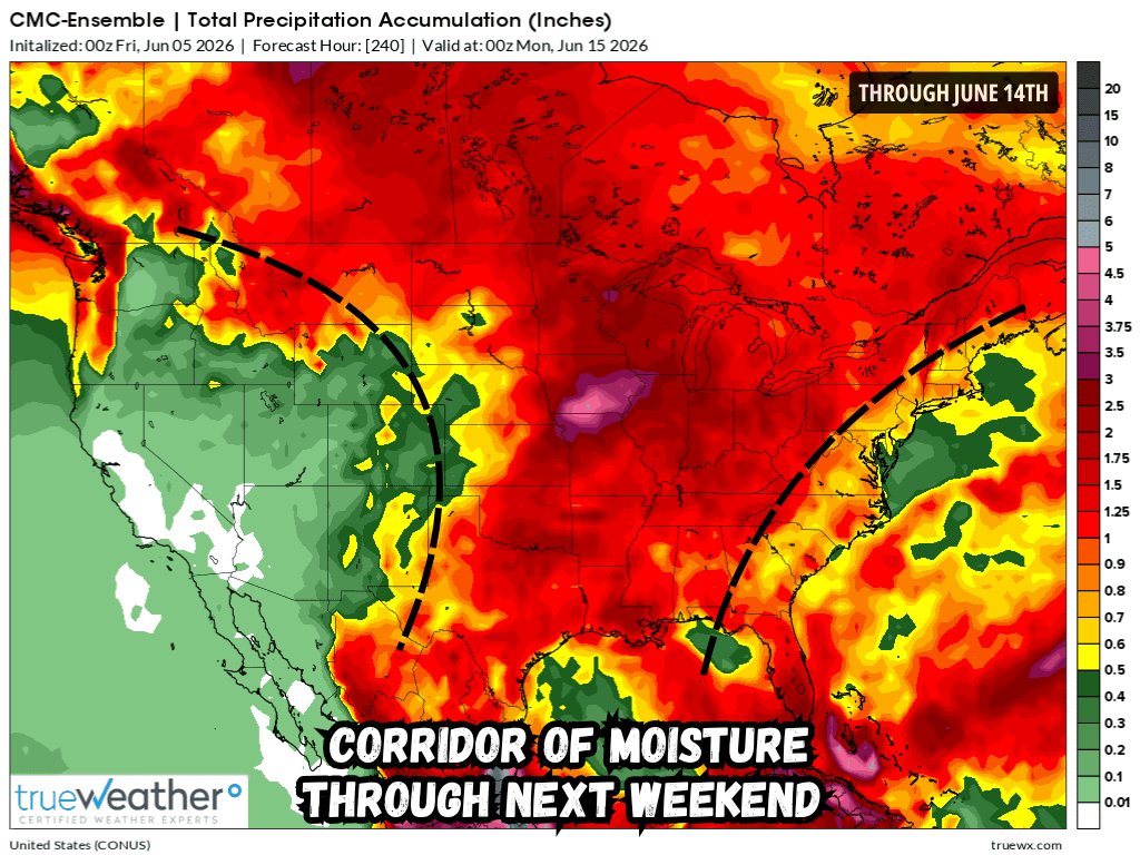
A rinse-and-repeat pattern will continue through mid-June, bringing widespread 1-3" #rainfall totals across the Central U.S. and #MississippiRiver watershed. Meanwhile, #west of the #Rockies and #east of the #Appalachians things stay dry, with many locations seeing less than .5".
#𝗘𝗡𝗘𝗥𝗚𝗬 𝗨𝗣𝗗𝗔��𝗘 - Above-average temperatures should hold across much of the Mountain West through mid-June, especially across the Central and Southern Rockies while the broader pattern supports above-normal gas-weighted cooling degree days.
#OOTT#NaturalGas#Gas#Oil
𝙇𝙊𝙉𝙂 𝙍𝘼𝙉𝙂𝙀 𝙊𝙐𝙏𝙇𝙊𝙊𝙆 - Mid-June brings near or above normal temps to most of the Lower 48. The strongest warmth will focus around the Southern #Rockies. Meanwhile, the Northern Plains and Central Gulf Coast consistently favor wetter-than-normal conditions.
#Weather
A mainly dry pattern is expected across the #Southwest through the next couple of weeks, with much of #California, #Nevada, #Utah, and #Arizona seeing little, if any, rain. Many areas may see less than 0.50" through mid July, allowing #Drought concerns to gradually worsen.
After back-door cold fronts kept the #Northeast cooler, summer warmth is finally on the way. Temperatures across the northern #MidAtlantic climb into the upper 80s and low 90s later this week into this weekend, while #NewEngland replaces 60s and 70s with low and mid 80s.
Multiple rounds of severe storms are expected across the #Dakotas late Tuesday through midday Wednesday, especially near the North Dakota and South Dakota border. Damaging winds over 55 mph, large hail over 1", heavy rain, and an isolated tornado risk are possible. #SevereWeather