Engineer and Creator of @BrilliantLime Artisanal Small Batch Tonics. Passionate Golden State Warriors STH since 1987 #DubNation. Mountain and Road Cyclist.
Severe Convective Storms hit a third of the country in one week.
157 tornado warnings. 784 severe T-storm warnings. 78 tornadoes. An EF4 in Oklahoma. 4.5" hail in Arkansas.
The costliest US insured nat-cat peril, mapped:
https://t.co/7B6AUU8ZpI
The biggest wildfire threat isn't the fire — it's the smoke.
In 2021, 10 fires burned 2M acres. The smoke covered 7.5M km² — larger than the entire US — with AQI hitting 500 over 2,000 miles from the flames.
https://t.co/riFmgK1tmJ
Cyclone Narelle crossed an entire continent — Cat 4 into Queensland, 4,500 km across Australia, rebuilt to Cat 4 off WA, forcing LNG plant shutdowns.
179 intelligence products in 11 days. Full analysis + interactive track map:
https://t.co/KG0deNF8Zy
Most organizations don’t have visibility into risk as it’s unfolding.
We launched a free, public-facing live disaster and risk map to make that easier:
👉 https://t.co/Yhq1jQYwlo
Real-time hazards + city-level risk scores across the U.S.
A simple way to explore what’s possible with better risk intelligence.
(Full platform = global, deeper analytics, APIs, and more)
Rest of world coming soon
Significant tornado activity has already occurred in early March, well ahead of the traditional peak tornado season (April–June). We have recapped these recent tornado outbreaks and their impacts for you.
First wave (March 5–7): Strong wind shear, high storm-relative helicity, and unusually high CAPE for early March. A stalled warm front along the Indiana-Michigan border triggered explosive supercell development.
Second wave (March 10): A second powerful storm system produced the EF5 in Indiana and the long-track supercell that devastated communities from Illinois through northwest Indiana, along with historically large hailstones.
This outbreak is a stark reminder that significant tornadoes — including the most powerful EF5 category — can occur outside the traditional peak season. Make sure you are prepared with a platform like DisasterAWARE to monitor tornados in real-time, provide automated hazard detection, and insights from radar signatures, ground truth reports, and NWS damage assessment surveys.
https://t.co/22PkZCiNeQ
A rare Kona Low storm just delivered historic flooding across Hawaii—rewriting rainfall records, cutting power to 100,000+ people, and triggering statewide emergency declarations.
But beyond the headlines, this event is a reminder of something bigger: Extreme weather is becoming more intense, less predictable, and more disruptive to communities and businesses alike.
In this latest analysis, we break down:
- How the storm evolved and why it stalled over the islands
- The scale of rainfall and cascading impacts (flooding, landslides, outages)
- What this means for preparedness, early warning, and operational resilience
For organizations with assets, people, or supply chains in exposed regions, events like this aren’t edge cases—they’re becoming part of the operating environment.
https://t.co/iJuY607maa
#DisasterRisk #ClimateRisk #OperationalResilience #SupplyChainRisk #BusinessContinuity
Two weeks ago, a Kona Low system brought historic flooding to Hawaii. Before communities could begin recovery, a second storm hit — turning already saturated ground into a statewide crisis.
The numbers tell the story:
- $1 billion+ in estimated damage
- 233 people rescued across the islands
- 32 road closures — including the complete isolation of Haleiwa on Oahu's North Shore
- 5,500 residents evacuated as a 120-year-old dam threatened to fail
- 13 schools closed, a hospital evacuated, and a 176-year-old coffee farm devastated
Governor Green called it "the largest flood Hawaii has seen in 20 years."
We published a detailed analysis of the second week of flooding, including an interactive map showing every flood warning, road closure, stream gauge reading, and storm report across the islands.
What makes events like this so challenging for organizations isn't the first storm — it's the second one arriving before recovery is complete. That compounding effect is exactly what persistent hazard monitoring is designed for.
https://t.co/aw8T79dTXH
#NaturalDisaster #ClimateRisk #FloodRisk #Hawaii #Resilience #RiskManagement #DisasterResponse #OperationalResilience
The 2025 Atlantic hurricane season was notably active, continuing a pattern of above-average activity that has defined recent years. Multiple named storms made landfall in the United States and Caribbean, causing billions of dollars in insured losses and significant supply chain disruptions across the Gulf Coast, Southeast, and mid-Atlantic regions.
We have 5 recommended actions risk teams should take before June 1, 2026. Check out our blog post to read them.
The 2026 hurricane season will arrive on schedule. Whether it delivers average or above-average activity, the organizations that fare best will be those that treated March through May as preparation season — auditing exposure, testing plans, and ensuring they have the monitoring infrastructure to make fast, informed decisions when it matters most.
https://t.co/SHq6XUocPR
Hey @Nike@nikebasketball Given the #DubNation City Uni’s in Brown, they need some brown (instead of black) under garments, specifically for GP2 and PSpencer…make it happen! @NBA
@gvieralopez@svpino Seems to me for local environments and loadenv() with a .env file might be easier for some then doing:
set -a
source .env
set +a
Perhaps a benefit of the former is if you need to change an environment variable, you change the .env and that’s it, but in sh need to re-source.
@svpino Hey Santiago, I know you chose this intentionally, but why:
$ uv run -- python https://t.co/o4uoHIri40
vs.
$ uv run https://t.co/o4uoHIri40
or
$ uv run python https://t.co/o4uoHIri40
Is this just "habit" given you might need to use "--<cli arg>" with python in this case?
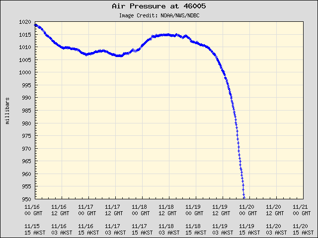
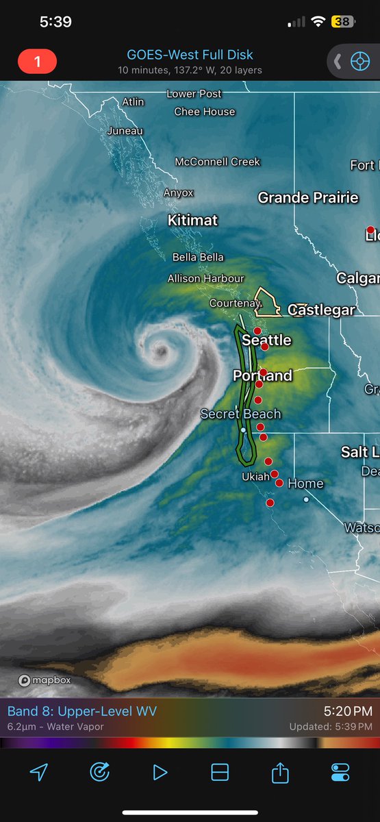
Data Buoy 46005 out in the Pacific off the Coast of Washington. YES, the bottom has fallen out!!! Look at that pressure trace, 950.5mb (28.07 in.) at 21z. Quick math shows 62.5mb drop in 24 hours. #storm@NWSSeattle