🌧️SAT: Expect on/off rain showers across all of NJ. Central and Southern NJ will see the heaviest, steadiest rain through early afternoon.
Conditions can improve after 3PM for northern counties, where rain ends statewide near or shortly after 5PM.
@News12NJ#NJwx
⛈️Tonight 10PM-3AM: Passing storms, mostly north of I-78. Few showers reach central NJ pre-dawn FRI AM
🌧️SAT 5AM-5PM: Damp day with scattered rain (highest chances Central/South). North of I-80 may improve by 3pm!
⛅️SUNDAY: Sun, clouds & a spot PM shower.
@News12NJ#NJwx
Midweek weather will have you feelin' happy as a clam with warm sunshine with highs in the mid-80s and quiet conditions.
Rain returns Friday & Saturday.
@News12NJ#NJwx
💦 Meaningful rain is on the way with flooding & wind.
🌧️ Rain, wind, & possible flooding start around noon, peaking this evening with rain totals up to 2"+.
💨 Damaging gusts & a low tornado risk are present for NJ. Unsettled weather lasts into tomorrow.
@News12NJ#NJwx
🙃 High bust potential for THU's storms depending on cold front timing!
🌦️ TODAY: Mostly cloudy, stray pop-up t-showers & brief downpours.
⛈️ THU: Quick AM front = lower storm risk. Later front = heat/humidity triggering severe storms with damaging winds.
@News12NJ#NJwx
Muggy weather returns for Wednesday & Thursday! A front is expected to arrive on Thursday to wring it out for the weekend, though. So, its just a small fling with the juiciness this week!
@News12NJ#NJwx
Say "Bye Bye!" to the heat and humidity!
😎It’s going to feel incredibly beautiful today with a light breeze.
☀️Expect plenty of sunshine and highs in the low-to-mid 80s today and tomorrow.
Storms likely return THU, but enjoy this for now! @News12NJ#NJwx
Happy Sunday! 😍
It's going to be gorgeous today! Breezy at the coast. The UV is a high: 9. Sunscreen is a must, even with afternoon thin clouds! ☀️🧴
⛈️ T-storms roll through late (7PM-MIDNIGHT) with risk of strong & damaging gusts.
@News12NJ#NJwx
🥵RINSE & REPEAT: Highs are back in the mid-90s today with humidity.
⛈️ STORMY WINDOW: 4PM-11PM (Most likely 6-7PM): Models are inconsistent, but a statewide risk for damaging 60mph winds, downpours & lightning is there as a front passes through tonight.
@News12NJ#NJwx
@GrantMulvey82@iDenville@News12NJ Storms were isolated yesterday, which means they're spaced out. Most of yesterday's storms were south/central NJ. No organization in this air mass, so it's hard to pinpoint the 'popup'-point, but the lingering clouds prevented storms north!
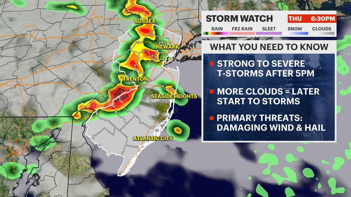
⚠️Severe storms this evening with some starting as early as 5PM, ending near 11PM
Main threats:
- Damaging winds (60mph+)
- Hail
- An isolated tornado can't be ruled out
Highs 94-98 (feels like 100-105)
When thunder roars, head indoors!
@News12NJ#NJwx
⛈️ Storms return with higher heat & humidity this week.
WED 3-6PM: Scattered storms, hail, strong gusts.
THU 6-8PM: Worst day. Fast storms, damaging gusts, downpours.
FRI 8-11PM (Timing can change): Storms clear out humidity for SAT (heat stays).
@News12NJ#NJwx
INCREDIBLE WEEKEND WEATHER
🥳Sunday rain chances have dropped!!! It's trending sunny and warm instead!
Just watch for a few leftover storms passing along and north of I-80 on SAT 7PM-10PM. A few storms could bring strong gusts.
@News12NJ#NJwx
There is still great uncertainty regarding the timing and intensity of the CMEs here at Earth. We appear to be dealing with at least 3 CMEs, one of which is faster than the others, so a combination event is likely. Keep visiting https://t.co/TV7Yw6LXRw for the latest.
✨ Northern lights in NJ tonight?
A G3 solar storm is possible!
WHEN: 8PM-1AM looking *very* low on the northern horizon away from city lights. Use a long-exposure photo to catch faint pink/green hues.
OTHER IMPACTS: Minor GPS lags possible during the day. @News12NJ#NJwx