Check out the low cloud and fog gradually clearing out of Wanaka via the Clutha River valley 🌫
Cold air sinks, so it flows down hills, and when it's carrying enough moisture you can watch it move 👀
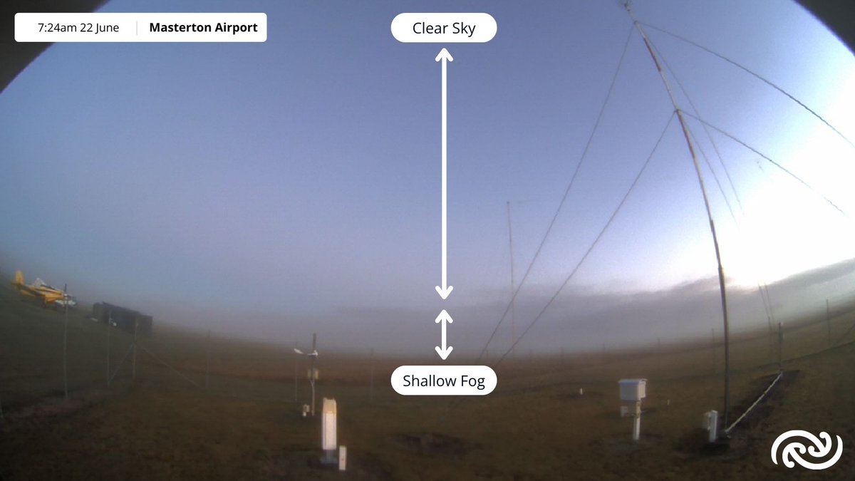
Visibility at Masterton Airport is currently around 300 metres. A shallow bank of fog formed as the sun rose, and should clear out once it gets a little warmer.
🔷 Chilly midwinter morning incoming 🔷
A soggy blanket of cloud kept things relatively warm on Sunday morning, but clear skies and light southwesterly winds on the longest night of the year send us sliding back into typical winter temperatures and frosts on Monday morning 🌃
Yesterday Christchurch and Ashburton airports smashed their June temperature records, but today both are over 12°C colder than they were 24h ago 🥶
This afternoon is forecast to creep up to 11°C, but clear skies on the longest night will bring a frosty start tomorrow🧊
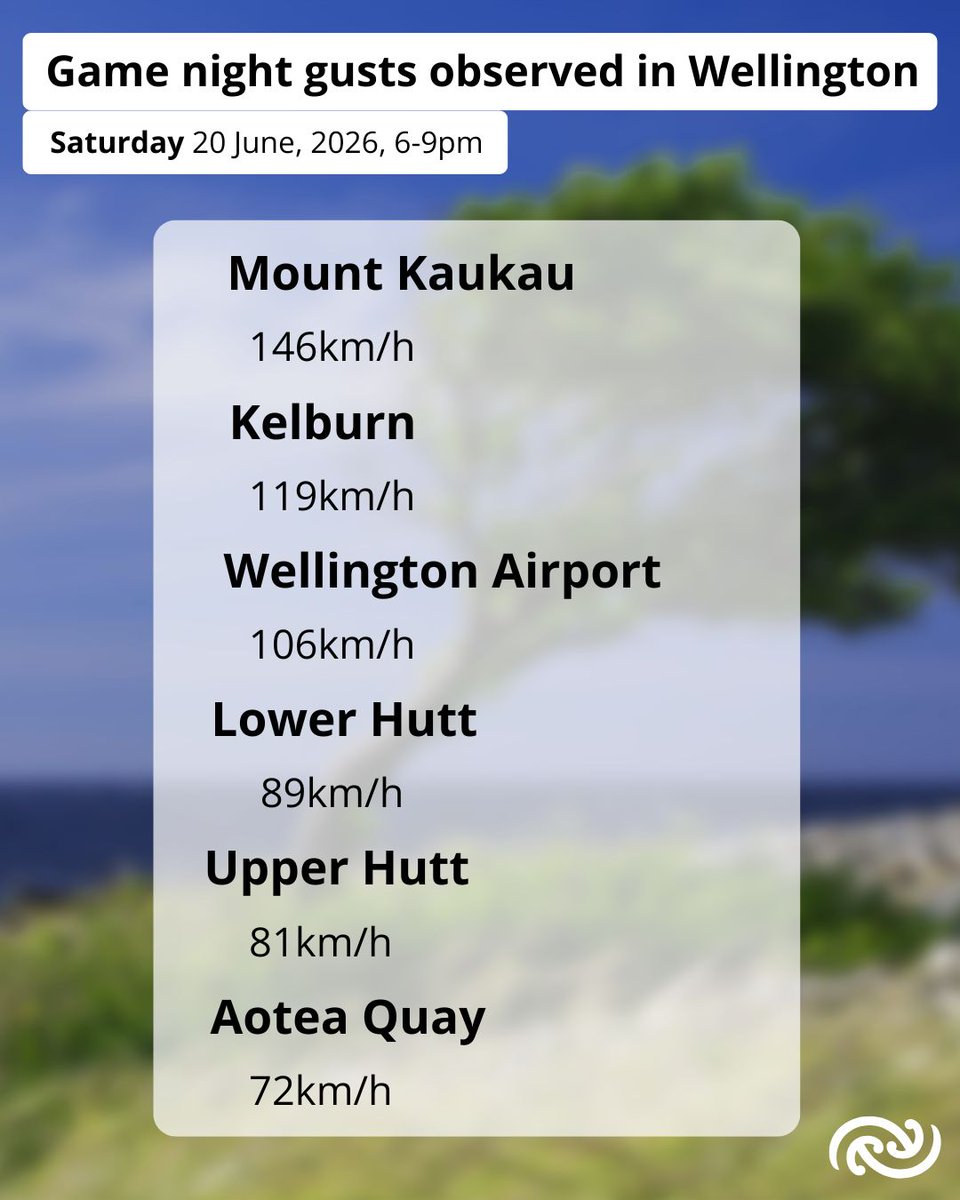
As a Wellingtonian and a meteorologist, I'm a little biased, but I reckon the Hurricanes have the most regionally-appropriate name in Super Rugby 💨
Aotea Quay, over the road from the Cake Tin, had several 72km/h gusts during the game, while Hamilton only managed 22km/h 💪
Also, Asburton reached 23.8°C at midday, beating its previous record of 21.7°C in 2024.
Up on Banks Peninsula, Cooptown was 25.1°C at 1pm ♨️ ‼️Severe northwesterly gales recorded in Canterbury today. Springfield had gusts of 124 km/h 11am, and Methven gusted 126 km/h at noon. ↘️🍃
🟧🟨Check the Severe Weather Warnings page https://t.co/UAYDdPbE5R Keep up to date with your weekend weather https://t.co/RsYoaxwutR
🟧🟨Severe Weather Warnings and Watches
for Heavy Rain and Severe Northwesterly Gales
for southern and central Aotearoa New Zealand
have been updated. 🌧️🍃
‼️Mostly valid for today Saturday, but some into Sunday.
All the details here
https://t.co/UAYDdPbE5R
@NZcivildefence@nztamain@greaterwgtn@ChristchurchCC@ECan
Ata mārie Aotearoa.
A warm night for central and southern Aotearoa
New Zealand, with Ōtautahi Christchurch
and Kaikōura heading to a high of 21℃ today. 🌡️📈
🟧🟨Severe Weather Warnings and Watches
for heavy rain and strong winds updated by 10am.
Warnings page here
https://t.co/aLLm9ugbrH
Everything else in weather
https://t.co/RsYoaxwutR
☀️Lunch is served South Island☀️
👉It's a settled weather sandwich 🥪
Take a bite while you can, because it won't last for long. And North Island, get hungry because it's coming for you too 😎
For your forecast check here: https://t.co/WmuNA9W6CR
🚌Rainband just in time for the Auckland morning commute!🚇
🌧️A front bringing rain is continuing to march 🪖across the North Island this morning. The band isn't too wide, so a period of rain can be expected followed by some showers, gradually easing with a 'fining up' 🌤️ trend to the rest of the day.
Check your forecast here 👉https://t.co/AsOyxTGk27
😵💫 Last time Shaq and I checked, temperatures increase during the day and cool off at night, but at times like this when wind is the main driver of the temperature, anything can happen!
📉 Here's the whole graph showing how the cold southerlies have completely cancelled out any daytime warming.
#Christchurch, can you relate to our man Shaq here?
🌡️ Maximum temperature for the day happened at 3am!
This was due to a temporary warm nor-west wind, which tried to come back at 5:30am just before the cold southerly air arrived.