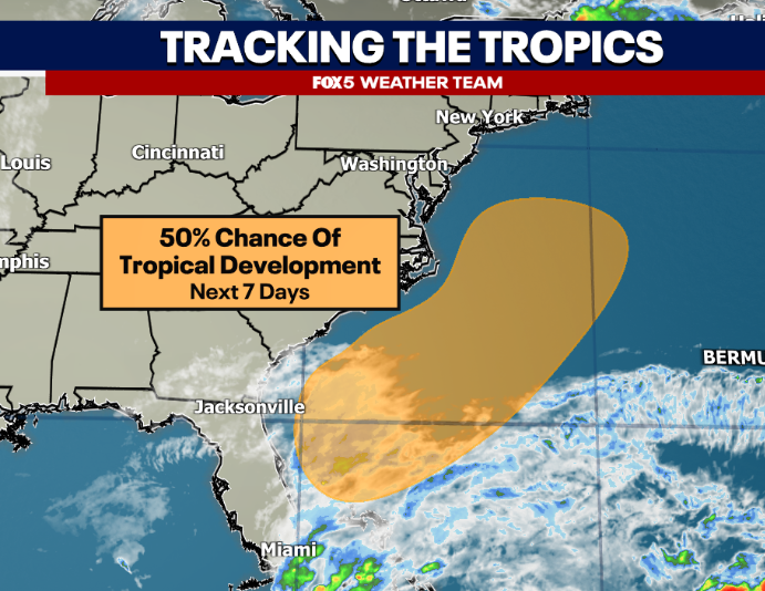
NHC up to 50% chance that this weekend's storm system gets a tropical designation before it impacts the East Coast. Depending on the track, might bring some heavy rain to the DC region on Sunday.
Kyle is the next name on the list if it gets a name. Hurricane season ends in just under two weeks.
Here's the Thanksgiving feature I mentioned with yesterday's post. Pretty strong Canadian high modeled north of the Lakes on Thanksgiving Day.
Now no 50/50 feature, so the cold air is leaving as the cold air comes up.
But cold air tends to be more stubborn than even AI models indicate at the surface. So could see it being something that becomes mostly an interior Northeast snow/ice threat. More skeptical of I-95 risks for winter stuff with it, they'd struggle more.
CPC has slight risk of heavy rainfall out for the entire East Coast around the Thanksgiving Holiday. No winter hazard zones at this time.
Looking ahead, around/just after Thanksgiving certainly early signs of active pattern in the East.
It's a little bit more interesting a pattern with models showing a brief spike in the PNA ridge late next week...but you are still struggling with strong cold air supply. It's certainly chilly...but the Pacific jet is still roaring off the West Coast so you have a lot of trans-continental milder Pacific air mixing in. Had those lower heights modeled near Greenland set up closer to the 50/50 low area, you could turn upper winds out of eastern Canada to get colder air farther south which would make a snow scenario more interesting. But at the moment, pattern gives a chilly rain look around the DC area.
Perhaps have to monitor for some type of cold air damming scenario farther north though, like interior Northeast depending on how the pattern ends up evolving.
It certainly an active pattern, and that's something I don't see changing too much over the course of the winter. Really just need one storm to link up with cold to make it a memorable winter around here, but so far early in the game, don't see that happening just yet!
This week's model battle has to do with a storm threat (rain here, not snow) early next week. Sunday-Monday time frame.
Reliable AI models like the AIFS (Image 1) and Google WxNext3 (Image 2) like the threat for a coastal rainstorm in this time frame.
The classic European Operational model (image 3) instead takes this wave and pushes it far offshore.
We're leaning closer to the AI for the forecast for now with a rain threat to kick off Thanksgiving week, but will be another fun case of AI vs Operational model guidance in the days ahead.
@Blaszeyboy With the overall pattern the AIFS & Google tend to be more accurate at this range.
All the AI models lean towards the wetter solution and when they all agree, I tend to believe them!
Ronnie you have to look at more than charts here. And again...not arguing against occasional burst of cold and I'm hoping that we can link some up at some point and get a bigger storm.
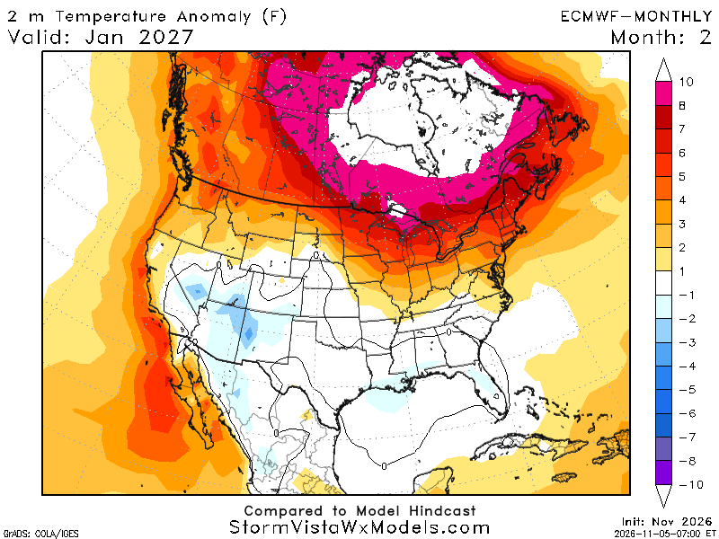
But while sure, the monthlies do favor longer -AO & -NAO regimes, you have a LOT of Pacific undercutting going on there. So that pattern us not as sustained cold as it may appear. Which is why the same model is not showing a crazy cold January. It's likely going to come and go in waves.
Just my 10 cents Ronnie! But yes I do see where you are coming from!
Not bad for the first larger snow of the season, several observations of over a foot of snow in elevated locations as well!
Think we'll see this type of thing a few times this winter with interior northeast snows while I-95 rains. Though still thinking we get lucky with 1 or 2!
More looking at temperatures with this write up...though will be on guard for either rain/snow type event somewhere with this setup which certainly matters given how busy travel is around this time.
Chilly through the weekend but another warm up is expected next week here in the DC region. Middle to upper 60s expected later next week through next weekend as well.
Next stronger cold outbreak then continues to look like right around Thanksgiving. What's too hard to say at this stage is...
(1) - Intensity. Details on the strength, location, and duration of the Alaska/Canada ridge spike matter here, as well as if there is any Pacific-North American (+PNA) component.
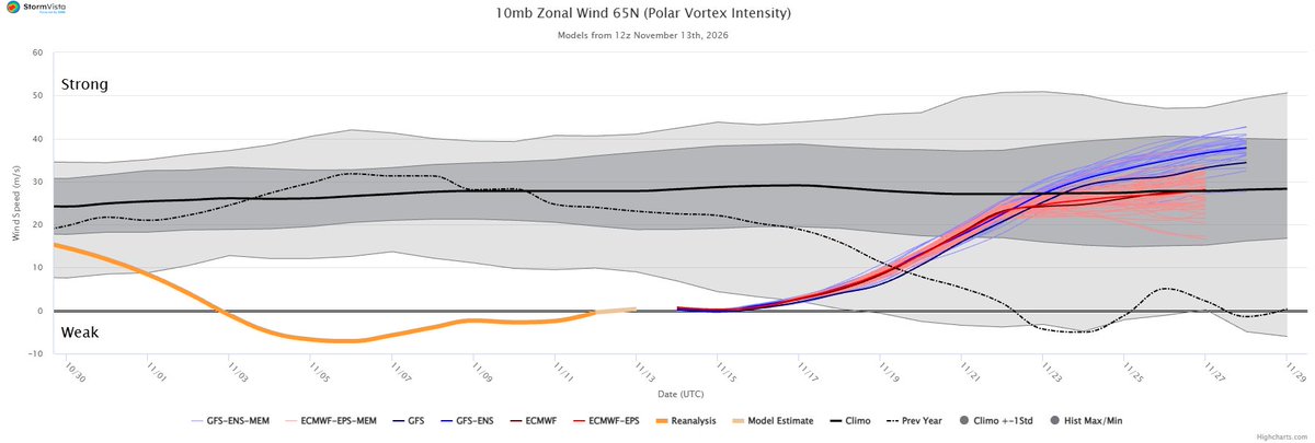
(2) - Duration. Most models agree on cold but the polar vortex is forecast to start regaining strength around this time as well. You can see the TPV mostly locked up to the polar latitudes, as least out of the AIFS. Still a strong Pacific jet signal as well, which would continue to flood the Lower 48 with "milder" (still cool to chilly, just maritime air mass compared to sustained, land/ice driven polar cold) air from time to time suggesting stronger cold pushes may be hard to sustain for too long. (see tweet 2 below)
(3) - Strom. Certainly a storm signal on the AIFS (as least for interior/northern areas) and I would suspect that just about every stronger cold push this season come with a storm threat, so expecting a busy season in that regard. But who gets snow and who gets rain will have to be worked out. We're talking an 11-15 day pattern here. As we saw with the storm this week, upper-level features will still shift, and surface features will follow suit as we get closer. Don't buy surface storm tracks shown at this range, though I'll show this run below for context. (see tweet 3 below)
At the end of that loop that you just sent you see the stratospheric PV retreat back to pole. Much closer to its climatological strength and position. Which is what the same chart showed that I tweeted. It’s not super weak and displaced like it is right now, but it doesn’t snap super strong either
At the surface, this run of the AIFS shows a storm in the day before Thanksgiving, though it's well off the coastline. If nothing changed with the upper level features though (it will...but lets pretend) then I would expect the surface low to actually get pulled farther west closer to the coastline. It would be modeled a bit too far east here given the location and strength of the upper low.
Still just under two weeks to watch all this. But of course Thanksgiving week is a huge travel week, so we'll keep an eye on it and continue updates next week!
Have a good weekend! Stay warm!
12z analysis of the polar vortex, showing it at very weak levels currently, though rebuilding strength towards the end of the month. Though it differs between a faster strengthening (blue - GFS) and slower one (red - ECMWF)
@AndroidParanorm In DC average is Nov 19th, but yes most others are late particularly IAD.
I do think that IAD and BWI get there in the next 5 days though.
First real snowmaking storm for interior parts of the Northeast tonight, pushing eastward tomorrow. Not impossible that New York City sees their first flakes of the season tomorrow morning.
DC will fight the clouds, and chilly winds through the weekend. Sweater weather for sure!