23 year old. Meteorology masters at Umass Lowell 25’. Meteorology Bachelor’s at Umass Lowell 24’. NWSBoston Skywarn spotter. Also loves photography and trains!
The epilogue to yesterday's large, long-lived tornado warnings issued in Massachusetts:
Not only were there zero tornadoes, but there were zero reports of strong wind and zero reports of hail.
And just like that, 464,998 have been conditioned to take warnings less seriously.
No idea why these tornado warnings are in effect in Massachusetts. There was some solid spin with the southern cell 20 minutes ago. Now we’re making close to a million people shelter needlessly.
Casting a giant net with big polygons and a low threshold degrades credibility.
NBC5 meteorologists believe a tornado touched down in Woodstock, Vermont. We have analyzed many damage photos. A rotation signature was visible above Woodstock. Trees are sheared off. Thousands of outages. National Weather Service storm survey needed for more detail.
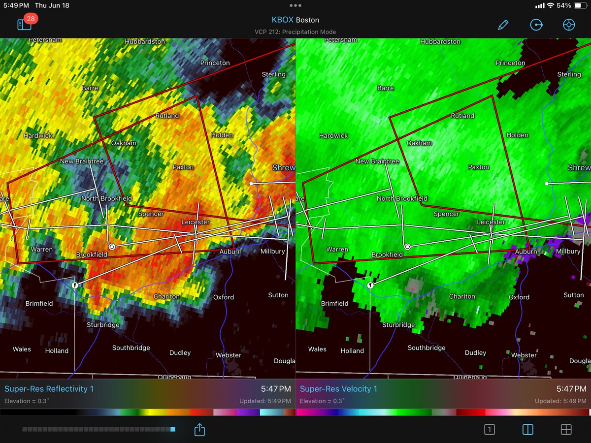
The northern cell’s rotation has mostly fallen apart and the tornado threat is now low. Gusty sub-severe level straight line winds (under 60mph) may still occur with this storm. #mawx
The northern cell’s rotation has mostly fallen apart and the tornado threat is now low. Gusty sub-severe level straight line winds (under 60mph) may still occur with this storm. #mawx
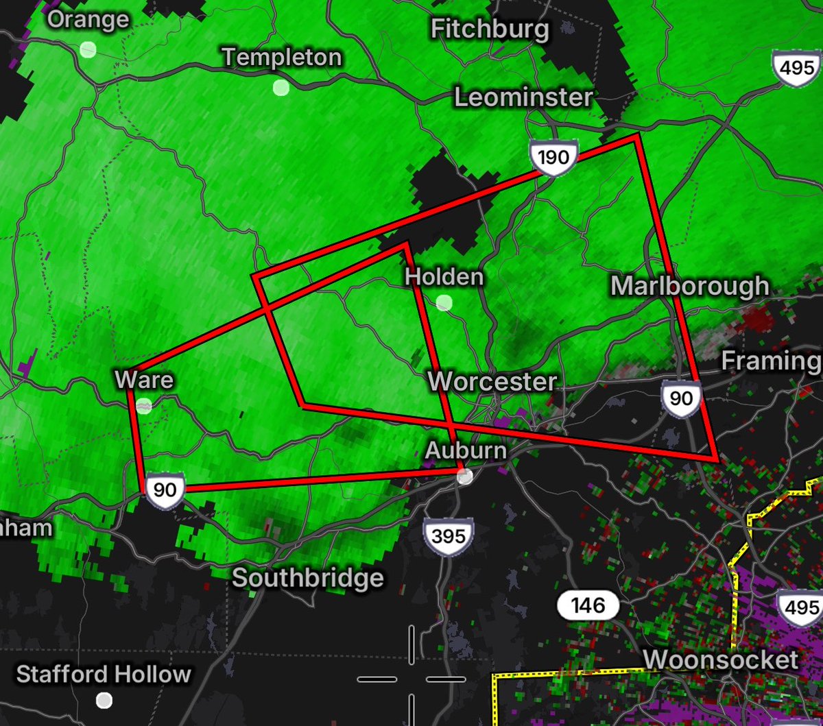
Daul tornado warnings in Central MA near the Worcester area. Both storms have tornadic potential with them, however the southern cell has tighter rotation. People in and near Worcester should seek shelter in the lowest floor of a building a tornados can develop quickly. #mawx
Daul tornado warnings in Central MA near the Worcester area. Both storms have tornadic potential with them, however the southern cell has tighter rotation. People in and near Worcester should seek shelter in the lowest floor of a building a tornados can develop quickly. #mawx
Wow! The HUXt forecast also indicates a possible double impact. The arrivals are expected around 5h and 9h UTC on June 5th, with the arrival window extending from late on June 4th to early on June 6th. Arrival speeds are in 700-800 km/s range, hit probabilities 80% and 47%. Far from a certain show, but it looks fairly promising.
Whoa!! The SWPC WSA-ENLIL model prediction for the first two CMEs is *impressive *! Direct double impact, with solar wind speed in 800-1000+ km/s range. If this pans out and Bt/Bz is very favourable we are easy in G3+ range. Even if solar wind speed is somewhat lower (CMEs arrive later), it could still be quite intense if Bt/Bz cooperate. OTOH it could gonthe same way as 19 January 2026 CME. High hopes, low expectations. Who's charging their camera batteries? :)
Here is the NOAA SWPC WSA-ENLIL model containing at least the M9.5 and X1 CMEs. We may expect to see an arrival around 18 UT tomorrow which is around lunchtime here in the U.S. Currently, G3 / Kp 7 conditions are predicted, but we'll see what happens!
WOW! This cyclone in the Mediterranean Sea made landfall in Libya this morning. You could see right down through the “eye” to New Brega City — I wonder if there’s any video!
This certainly seemed on the way to becoming a tropical cyclone. Impressive considering colder SSTs!