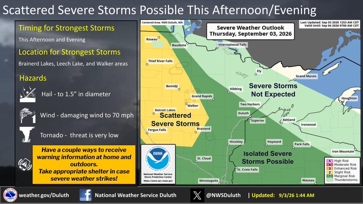
Storm chances return this afternoon and evening. The strongest storms will be over the Brainerd Lakes, Leech Lake, and Walker areas. Main hazards will be damaging winds and large hail.
A few thunderstorms have developed this evening near the I-35 corridor. Storms will track eastward into northwest WI, and likely be brief. Outside of any storms, winds are generally light. #MNwx#WIwx
Storm chances return Thursday evening and overnight. The strongest storms will be over the Brainerd Lakes area and in the I-35 corridor south of Hinckley. Main hazards will be damaging winds and large hail.
On and off chances for showers and storms will return later this week. Some severe storms are possible Thursday night. Temperatures will continue to be above normal for most through the weekend before a cool down next work week.
Rain and storm chances return Thursday afternoon and persist through Saturday. A few storms on Thursday may be severe. Highs will range from the low 70s to mid-80s through the period. Plan ahead for outdoor activities! #WIwx#MNwx
New today: IL state record hailstone of 6.6" (length). New records for weight & volume were established. The US record remains Vivian, SD at 8" (https://t.co/kAkfB47OQQ). MN record is 6" which occurred twice (https://t.co/J6aILvM8SG). WI record 5.7" (https://t.co/aLZEa3meji)
Illinois officially has a new state hail record! ⛈️ A colossal hailstone, measuring 6.603 inches in diameter, was confirmed by the SCEC following a storm on March 10, 2026, near Kankakee, IL. It reached historic size, weight, and volume! Learn more: https://t.co/rToflKSy3q
@MrDavidCarter That's a new one for me. 😄 The one that always catches my when I'm not paying close attention is "unseasonable" (temperatures, etc). My brain usually sees that as "unREASONABLE" the first time reading it. 😅
Dense fog continues through early this morning, mainly in northwest Wisconsin and immediately near Lake Superior along the North Shore. Use low-beam headlights and allow for extra stopping distance. Dense Fog Advisories are in effect. #mnwx#wiwx
Tonight's Forecast: Mostly cloudy with a ~30% chance of rain/thunderstorms for parts of east-central MN into northwest WI. Wednesday is looking dry, then shower/storm chances increase Thursday/Friday. #mnwx#wiwx
Areas of dense fog through early this morning, particularly in northwest Wisconsin and immediately near Lake Superior along the North Shore. Use low-beam headlights and allow for extra stopping distance. A Dense Fog Advisory may be needed in NW WI if fog becomes more widespread.
Expect above-normal temperatures throughout the week, with high temperatures ranging mostly from the mid-70s to low 80s across all areas. Intermittent rain chances return later in the week, particularly around Friday and Monday
Scattered showers and thunderstorms are moving through the Arrowhead early this morning. Storms are sub-severe, producing periods of heavy rain and wind gusts up to 20-30 mph. Very small hail is also possible in the strongest storms. Storms exit by mid-morning. #MNwx#WIwx
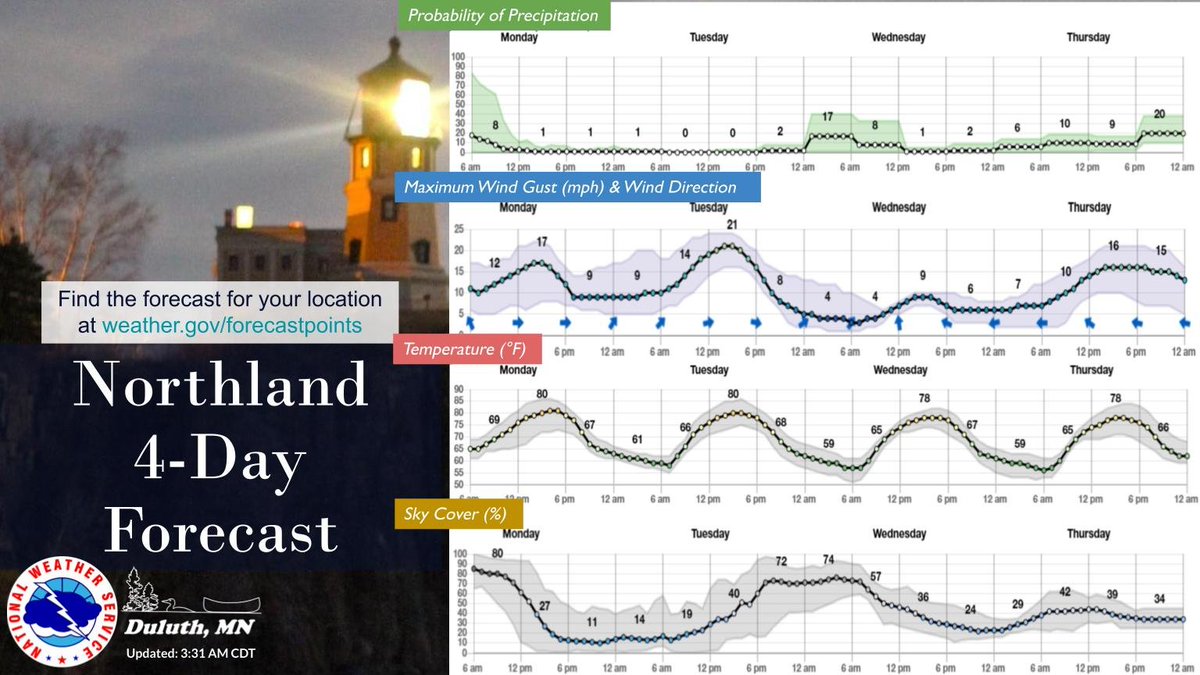
After this morning, a quiet beginning of the week is in store. Showers and storms continue this morning before a dry period through the mid week. Temperatures will be slightly above average in the upper 70s and 80s this week, warmest today and Tuesday.
Showers and general thunderstorms are moving through the Arrowhead. A second round of storms in north central Minnesota could lead to gusty winds and small hail over the next few hours.
Some showers and storms are moving through the Northland. They are general storms for now, but a line of storms in ND could lead to gusty winds and small hail later on tonight.
Here's a look at timing of showers/storms tonight. Expect storms overnight and diminishing Monday morning. This week, expect temperatures to remain pretty steady with highs in the 70s to 80s.
Look for some warm weather on Monday along with some thunderstorms, mainly during the morning. Temperatures remain roughly steady through the week with highs in the 70s and 80s with on-and-off chances for showers and storms.
The threat for severe storms is decreasing a bit for tonight, but strong storms that could produce hail and strong winds are still possible. Expect scattered storms this evening into Monday morning, especially in northeast Minnesota.
Strong northeast winds are expected for Lake Superior today-tonight. Dangerous swimming conditions are likely at Park Point to Wisconsin Point beaches. Waves up to 4-5 ft and winds 20-30 kt will also be hazardous for small craft on the water. Small Craft Advisories are in effect.
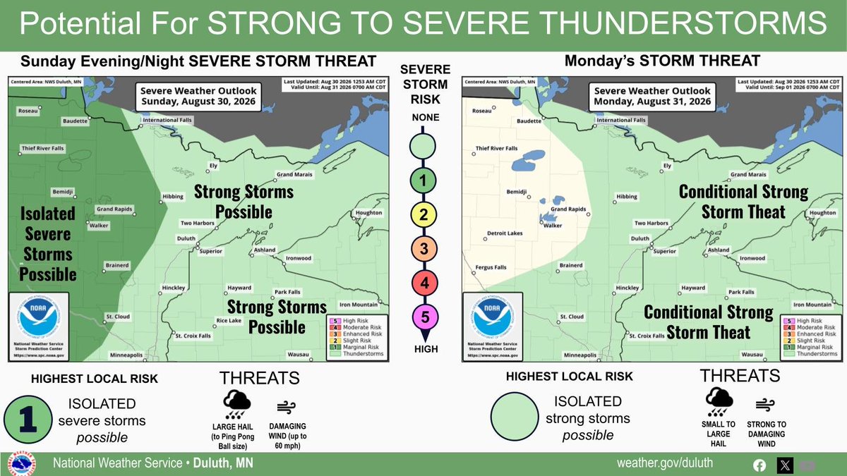
There is potential for strong to severe storms (level 1 out of 5 risk) this evening and night. Primary threats of large hail and damaging winds. There is a conditional threat for storms on MON PM. If storms form, the could produce small to large hail and gusty to damaging wind.