NATIONAL MARITIME DAY: Today we celebrate the thousands of men and women throughout the world whose hard work and dedication keep the maritime industry moving forward.
From cargo and cruise operations to harbor services and marine transportation, their skill and commitment help power global commerce, support our communities and keep ports like Port Canaveral operating safely and efficiently every day. Thank you to all who serve and support the maritime industry.
#NationalMaritimeDay #WeArePortCanaveral
America needs skilled workers to build the fleet of the future. ⚓
Under @POTUS’s leadership, the Labor Department is investing millions into revitalizing our nation’s maritime workforce and shipbuilding industry.
The Port of Los Angeles is proud to celebrate National Maritime Day, recognizing the importance of the maritime sector’s essential role in supporting global trade. We acknowledge the ongoing dedication and effort across the industry that helps keep America’s No. 1 port running.
On National Maritime Day, NOAA's National Weather Service Ocean Prediction Center salutes the maritime industry and all it provides to the nation. The OPC team works hard to deliver life and property saving forecasts in support of the mariner around-the-clock every day.
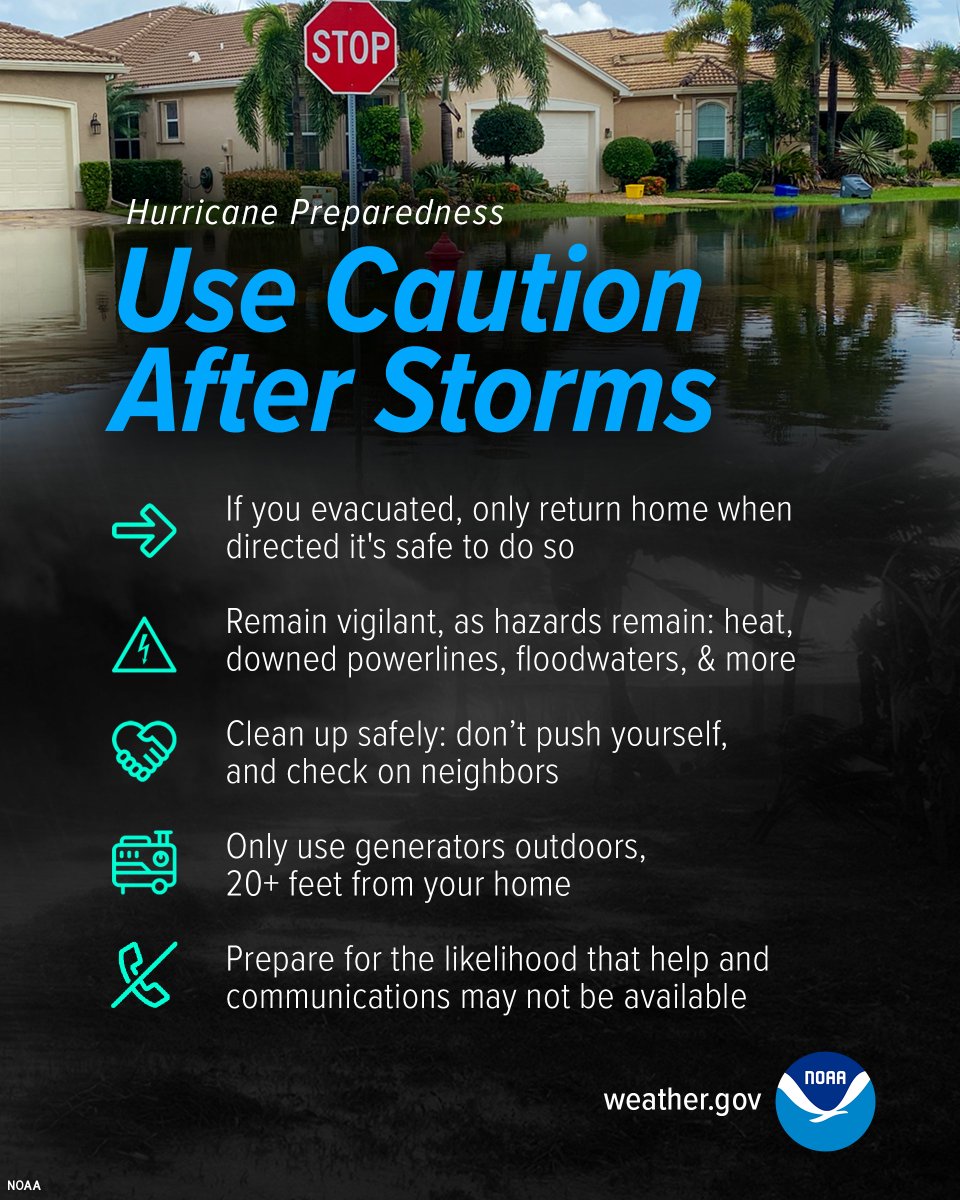
Dangers remain even after the skies turn blue. This is NOT the time to put your guard down. Nearly half of hurricane fatalities occur after the storm. Here's a video detailing some dangers after the storm passes: https://t.co/CsLe39C9U8
🌀Hurricane Preparedness Week Day 5: 🌀
Be prepared for hurricane season by knowing what to do during a storm. Whether you’ve evacuated or are sheltering in place, know what to expect from the hazards you may face.
https://t.co/8prXHph9Lv
Storm force wind warnings continue across the western Atlantic associated with a rapidly intensifying low pressure. Most up to date analysis/forecast info: https://t.co/N0GqocSYhm #MarineWx
Latest surface analysis across the Pacific shows a 958 mb, hurricane force low pressure approaching the Aleutian Islands and Bering Sea, with multiple stunning satellite views from Himawari-9 #MarineWx
Latest surface analysis across the Pacific shows a 958 mb, hurricane force low pressure approaching the Aleutian Islands and Bering Sea, with multiple stunning satellite views from Himawari-9 #MarineWx
Check out the latest blog post 'Typhoon Sinlaku and its Extratropical Transition' authored by Chris Smith, the CISESS GOES-R Satellite Liaison for NWS WPC/OPC https://t.co/f8Sv3whEW2 via @SatLiaisons
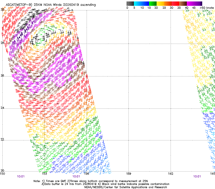
ASCAT passes returned hurricane-force winds to 65 kt southwest of a low pressure across the NE Atlantic, confirming the 63rd hurricane-force wind event of the 2025-2026 season. This is well above the previous 20 season mean, approaching our highest tally back from 2006-2007 (66).
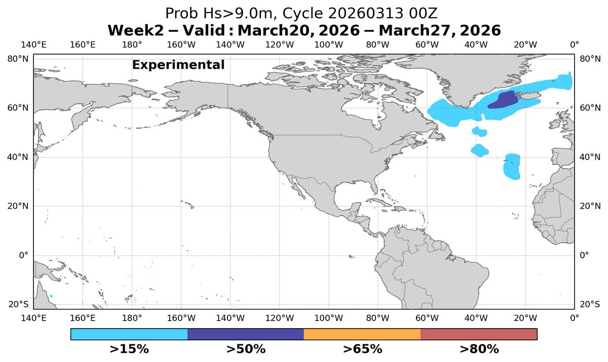
How did the experimental week-2 probabilistic outlook for the N Atlantic compare to the GDAS weekly composite March 28-April 4 time frame? (https://t.co/su5PjC9efb) Pretty impressive!! Compare locations of hurricane-force winds in each image along the Greenland coast. #MarineWx
[Mar 24] Low pressure will rapidly intensify across Newfoundland into the North Atlantic tonight, forecast to generate hurricane-force winds with significant wave heights building to near 45 ft / 14 m. #MarineWx Latest Atlantic info: https://t.co/N0GqocSYhm
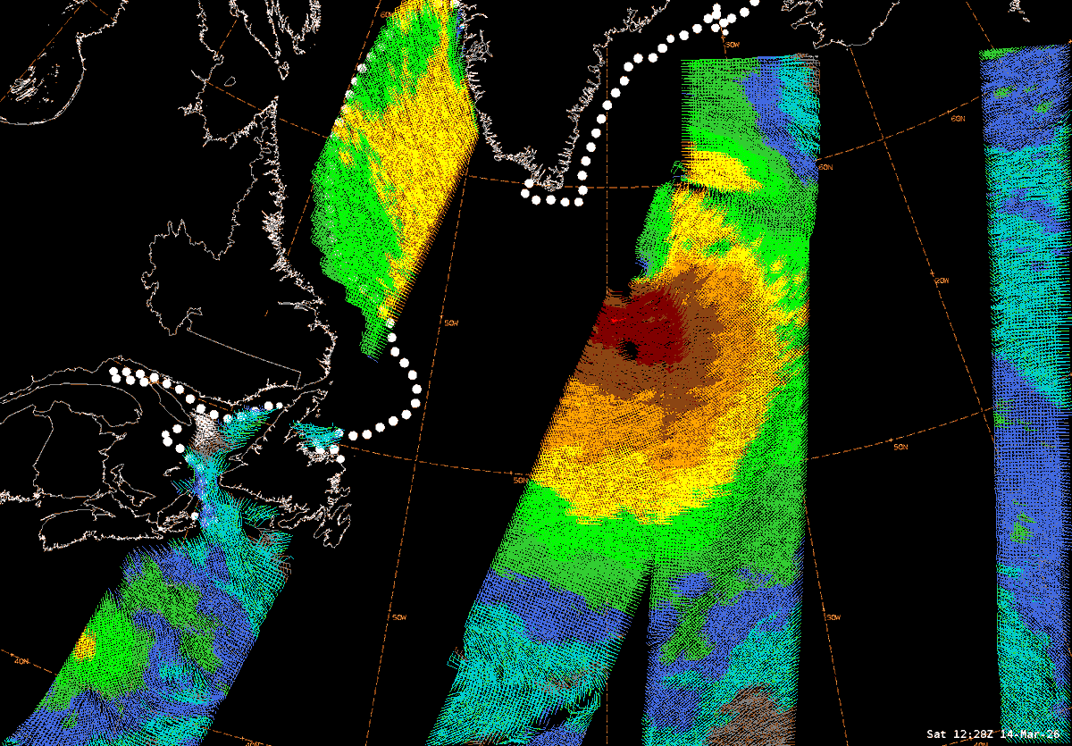
[Mar 15] While the low pressure from yesterday has filled slightly today and is no longer producing hurricane-force winds, an elongated fetch of strong storm force winds are generating very high to phenomenal seas, last analyzed up to 16 meters / >50 ft. #MarineWx
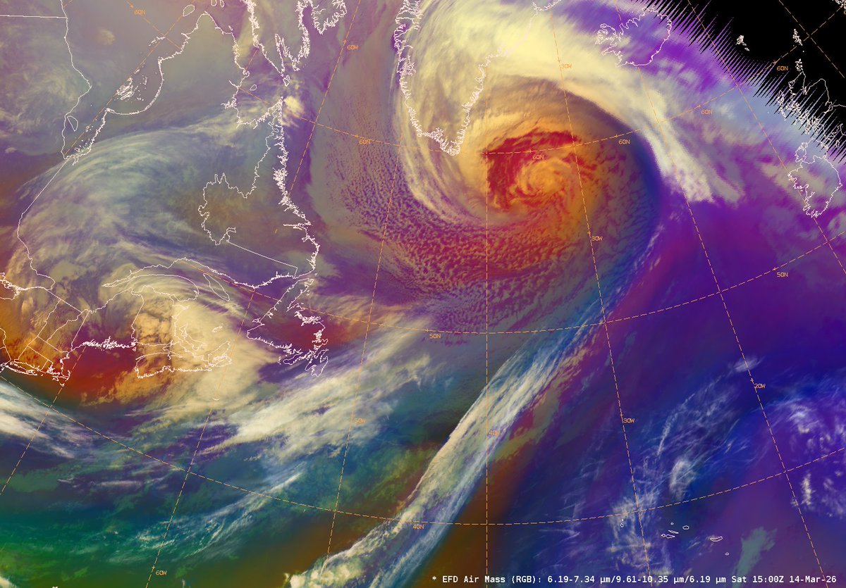
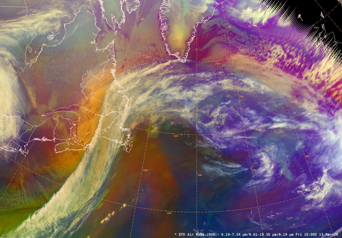
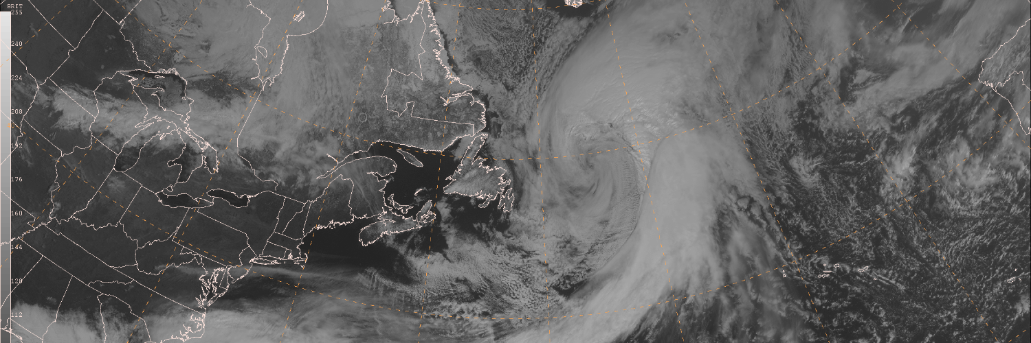
24-hr difference seen via GOES-E Air Mass RGB satellite imagery, from a 991 mb low yesterday near Newfoundland, to now a sprawling 956 mb low pressure SE of Greenland. Widespread gale, storm, and hurricane-force winds continue this morning, with seas in excess of 40 ft. #MarineWx
24-hr difference seen via GOES-E Air Mass RGB satellite imagery, from a 991 mb low yesterday near Newfoundland, to now a sprawling 956 mb low pressure SE of Greenland. Widespread gale, storm, and hurricane-force winds continue this morning, with seas in excess of 40 ft. #MarineWx
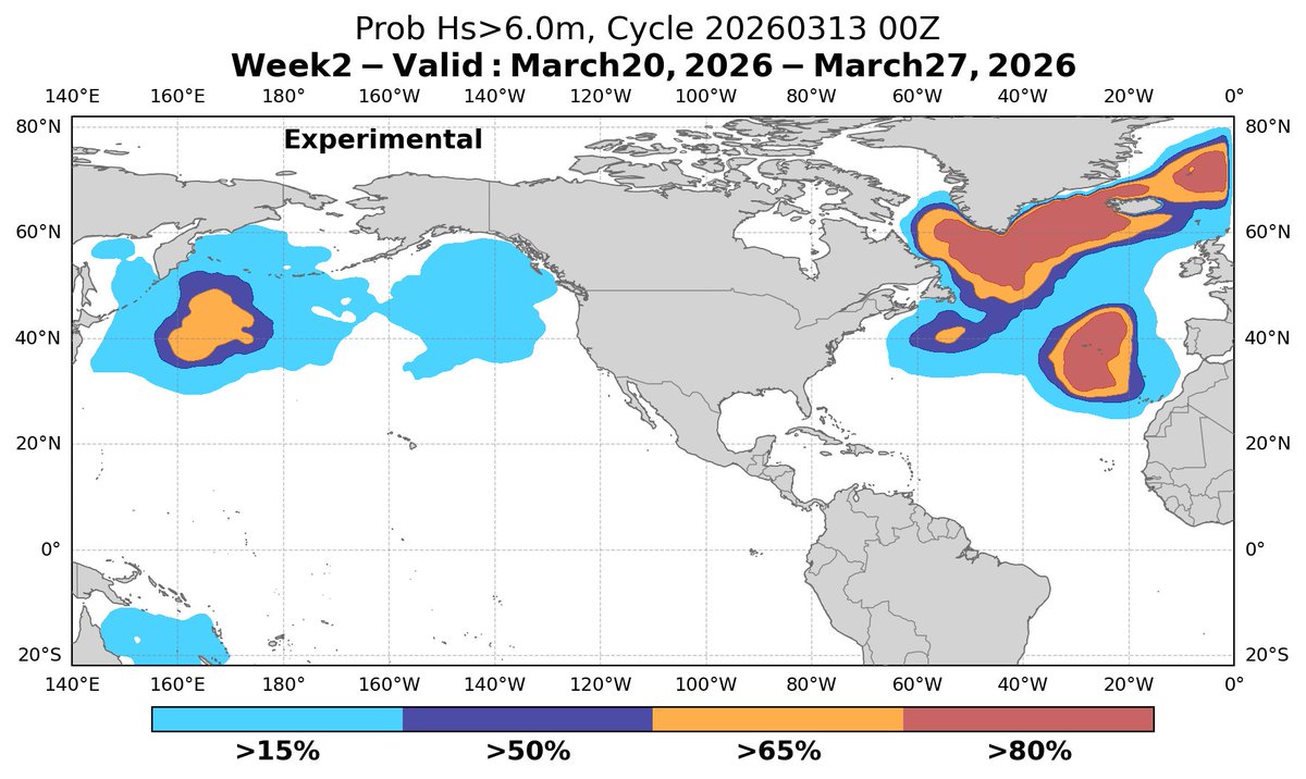
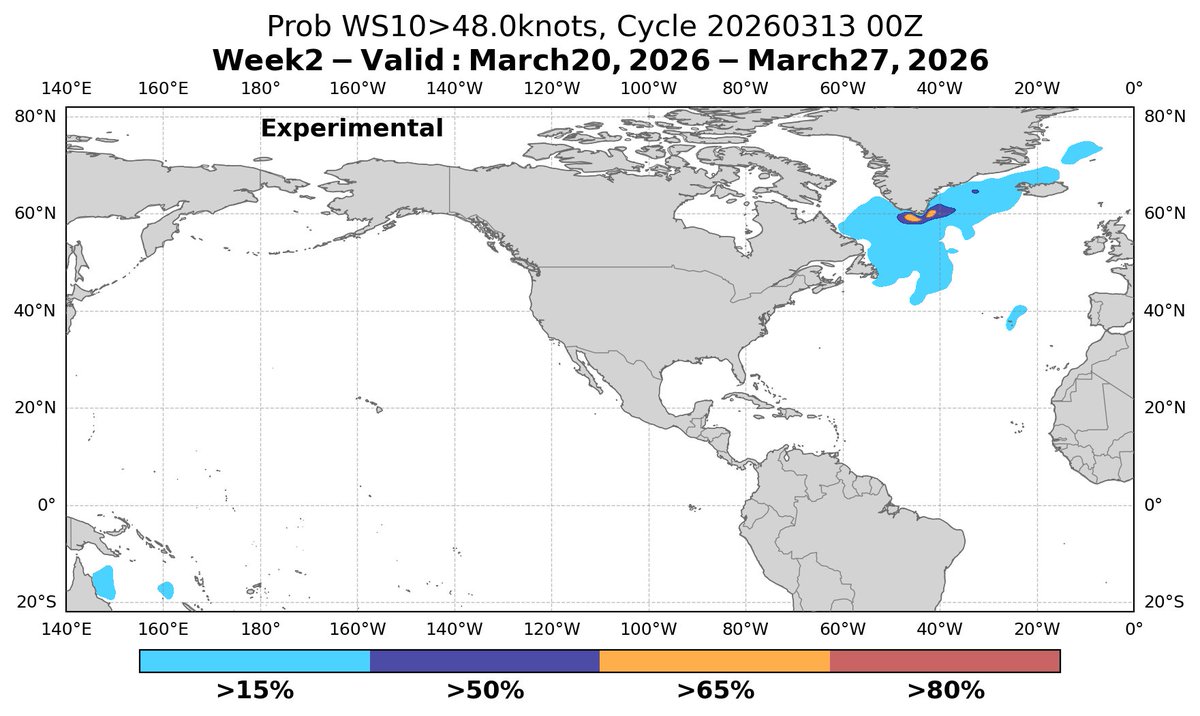
Experimental week-2 probabilistic outlooks show active weather likely continuing across both ocean basins March 20-27, in particular across the N Atlantic with widespread gale and storm, to possible hurricane-force conditions. Details and more info here! https://t.co/su5PjC9efb


![NWSOPC's tweet photo. [Mar 15] While the low pressure from yesterday has filled slightly today and is no longer producing hurricane-force winds, an elongated fetch of strong storm force winds are generating very high to phenomenal seas, last analyzed up to 16 meters / >50 ft. #MarineWx https://t.co/sOV1dAnfx2](https://pbs.twimg.com/media/HDeUxaRXQAAWOOo.png)
![NWSOPC's tweet photo. [Mar 15] While the low pressure from yesterday has filled slightly today and is no longer producing hurricane-force winds, an elongated fetch of strong storm force winds are generating very high to phenomenal seas, last analyzed up to 16 meters / >50 ft. #MarineWx https://t.co/sOV1dAnfx2](https://pbs.twimg.com/media/HDeUwuiXsAExek7.png)


![NWSOPC's tweet photo. [Mar 15] While the low pressure from yesterday has filled slightly today and is no longer producing hurricane-force winds, an elongated fetch of strong storm force winds are generating very high to phenomenal seas, last analyzed up to 16 meters / >50 ft. #MarineWx https://t.co/sOV1dAnfx2](https://pbs.twimg.com/media/HDeUzp4XQAAe7cp.png)