Pakistan is such a cowardly country , they cant even handle a small account like me🤣, so they banned my whole account ,thanks this is a badge of victory porkistan.
No Thanks , India should develop its own Indeginous Satellite Internet instead of allowing a Foreign Player to Cannibalise a sector which is also critical for National Security
We have worked closely with regulators, industry and operators in India for 5+ years, and built a network of dedicated systems, gateways, and other infrastructure all in-country to exclusively serve Indian traffic safely and securely - and all with the requisite government approvals.
Starlink is ready to connect India with high-speed internet.
Professor Muhammad Yunus received the Hillary Rodham Clinton Award today at Georgetown University. Former U.S. Secretary of State Hillary Rodham Clinton presented the award at a ceremony held in Gaston Hall.
Russian Missiles destroyed a factory belonging to the German Company Kromberg & Schubert in Lutsk , Ukraine .
Kromberg & Schubert is an automotive supplier company based in Germany
Security Alert: U.S. Mission Saudi Arabia (October 16, 2026)
U.S. citizens are reminded to follow the guidance of national alerts released by Saudi Arabia’s Civil Defense via cellular broadcast.
U.S. government employees working in Saudi Arabia require special authorization from Chief of Mission to use any airport in Saudi Arabia following recent missile and UAV attacks on airports in the Kingdom.
Saudia Arabia’s General Authority of Civil Aviation extended the suspension of operations at King Khalid International Airport in Riyadh through October 17. King Abdulaziz International Airport in Jeddah and King Fahd International Airport in Dammam are operational with some delays and cancellations.
U.S. citizens should be aware of potential attacks on airports, airspace closures, flight cancellations, and travel disruptions. Please take extreme caution if you choose to use airports in Saudi Arabia. We recommend checking your flight departure status directly with the airline and with the airport.
Private car, train, and bus options may provide alternatives to air travel to or from Saudi Arabia. Below are some transportation resources for your consideration. Please confirm availability and schedules directly with the providers.
- Saudi Arabia Railways: https://t.co/aXJ0z4Qcwy
- SAT Transportation: https://t.co/WP25alCywq
- SAPTCO: https://t.co/ZadKUfSCgq
International airports in neighboring countries of Bahrain (BAH), Jordan (AMM), Oman (MCT), Qatar (DOH), and the United Arab Emirates (AUH, DXB, SHJ) remain operational. Please confirm status directly with airports.
Saudi Arabia’s Ministry of Interior continues to warn that “filming, publishing, or sharing information related to counter missiles and drones, and their impact sites, exposes you to legal liability.” U.S. citizens have been detained for not adhering to these regulations, including taking photos of government buildings, airports, and impact sites. Visitors and residents are subject to local laws while in Saudi Arabia.
Read more: https://t.co/fQZIrs73sA
HOTAN PLAAF AIRBASE BUILDUP NEAR LADAKH.
I have skimmed through recent satellite imagery of the Hotan airport(PLAAF Airbase)which is nearly 250Kms from Ladakh and about 350 kms from Leh .This base falls under the western theatre command of the PLA and has undergone significant hanges not only to the base vicinity but also the surrounding settlements and towns .i will analyse Hotan in two/three seperate posts , this is the first one .More Images in this Thread in comments .
1)This is the new construction activity observed right below the airbase and we can see a branch road thats connecting directly to the airfield , this strip of road branches from a National Highway that connects further parts of tibet and along the road multiple structures are being constructed liekly military quarters if you go by the looks of theese structures/buildings.
2)We can see a Solar farm adjacent to the construction activity , Hotan prefacture has two or three such solar farms and likely will increase in coming years as industry activity will increase and we can also see the National highway that branches out inwards as explained in the first image .The national Highway is the G219 also caled Xinjiang Tibet expressway that branches from the occupied Aksai Chin(occupied ladakh).
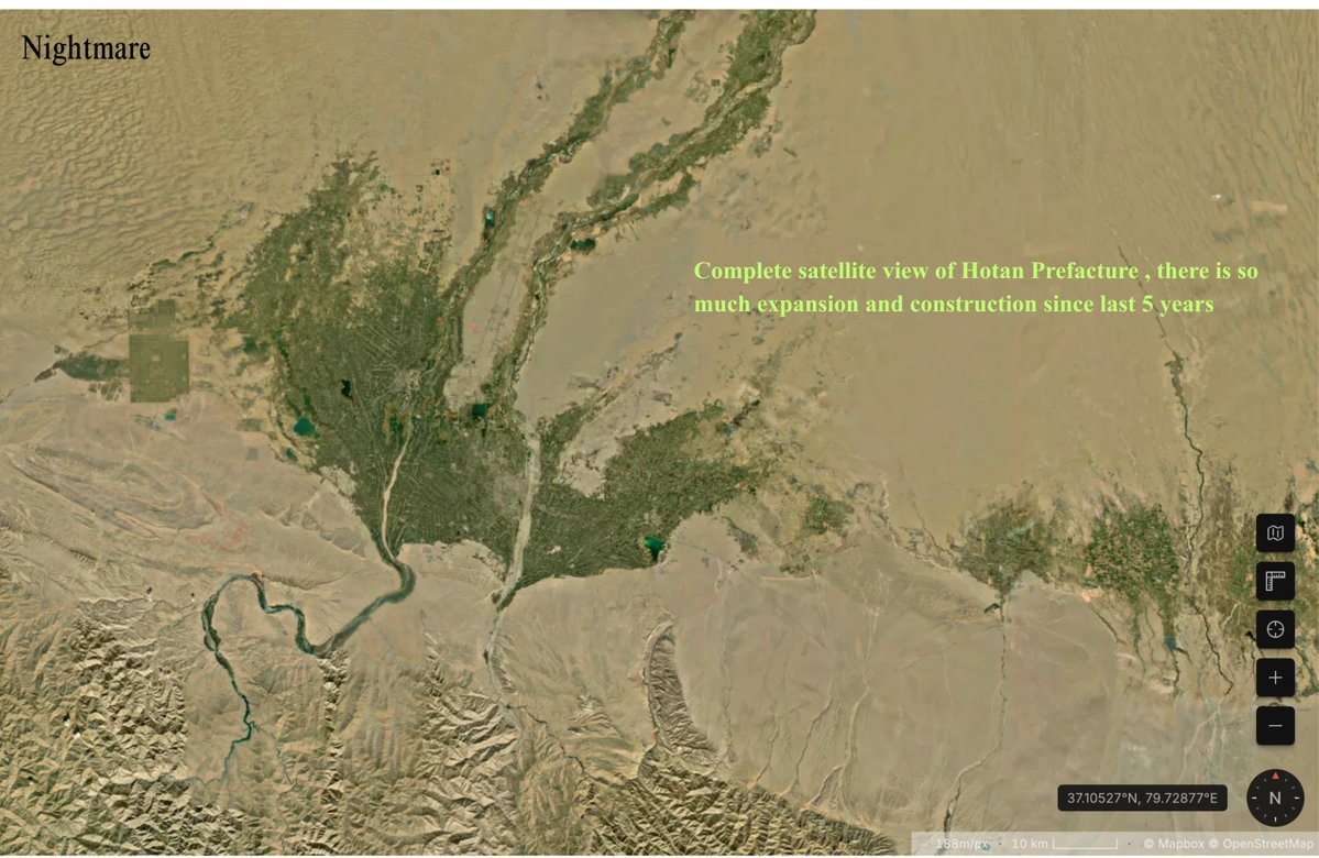
3)The third image is self explanatory its the total satellite image of the entire Hotan Prefacture , if you compare this recent image to Google Earth(the closest proxy i use) we can see massive developments and improvements for a border/frontier area.
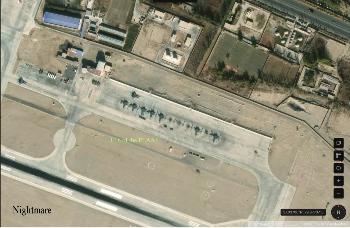
4)Now we move to the airfield in Hotan and this airfield has in past hosted J-20s and H-20 bombers along with other UAVs but currently is hosting multiple J-16 fighter jets , looking at multiple images i have put the estimate at 2 squadrons and in this particular image we can see 9 J16s and some are most probably preparing for test flights.
HOTAN PLAAF AIRBASE BUILDUP NEAR LADAKH.
I have skimmed through recent satellite imagery of the Hotan airport(PLAAF Airbase)which is nearly 250Kms from Ladakh and about 350 kms from Leh .This base falls under the western theatre command of the PLA and has undergone significant hanges not only to the base vicinity but also the surrounding settlements and towns .i will analyse Hotan in two/three seperate posts , this is the first one .More Images in this Thread in comments .
1)This is the new construction activity observed right below the airbase and we can see a branch road thats connecting directly to the airfield , this strip of road branches from a National Highway that connects further parts of tibet and along the road multiple structures are being constructed liekly military quarters if you go by the looks of theese structures/buildings.
2)We can see a Solar farm adjacent to the construction activity , Hotan prefacture has two or three such solar farms and likely will increase in coming years as industry activity will increase and we can also see the National highway that branches out inwards as explained in the first image .The national Highway is the G219 also caled Xinjiang Tibet expressway that branches from the occupied Aksai Chin(occupied ladakh).
3)The third image is self explanatory its the total satellite image of the entire Hotan Prefacture , if you compare this recent image to Google Earth(the closest proxy i use) we can see massive developments and improvements for a border/frontier area.
4)Now we move to the airfield in Hotan and this airfield has in past hosted J-20s and H-20 bombers along with other UAVs but currently is hosting multiple J-16 fighter jets , looking at multiple images i have put the estimate at 2 squadrons and in this particular image we can see 9 J16s and some are most probably preparing for test flights.
This is the second set of PLA/chinese border village satellite images iam posting about , this is even more intresting as it involves logistics centres and airbases along the Indian border .
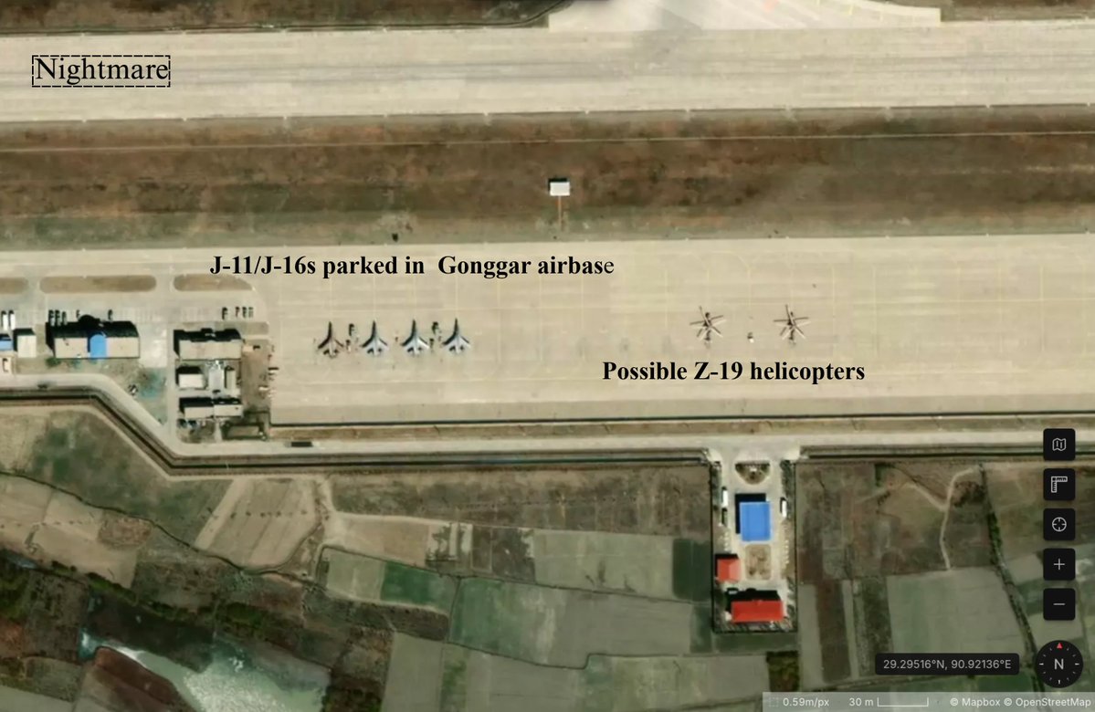
The first one is from 7VWX+348 Jiazhulinzhen, Gonggar County, Shannan, Tibet, China (in this case google earth has updated images they have built huge rows of hardened shelters in the base go check it if you like) , now this is the gonggar airport/airbase its near Lhasa and its used by the PLAAF heavily for training flights we can see in this particular image J-11 or J-16 fighter jets parked in the tarmac along with Z-19 helicopters used by the PLAAF the empty space behind these is where rows of new black hardened shelters are built in G earth indicating increased aircrafts by the PLAAF , this is important as this airbase is above bhutan and North east India .
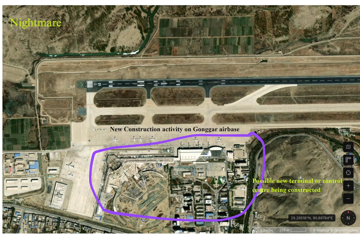
The second image is again from the same airbase but we go a little to the left side and here is where we can see multiple Airbus aircraft being parked and this is what i call civilian/cargo area of the airport but we can notice one huge detail in this sat image , construction going on for a possible terminal and control centre , pretty big ugrades for a border airport .
The third image 72QR+P7J Jixiongzhen, Gonggar County, Shannan, Tibet, China is right next to the main gonggar town , we see a rail terminal , most of these are mainly used for cargo transport as containers can be seen but they are always considered dual use by many analysts as they can transport military equipment and personnel too in times of need .
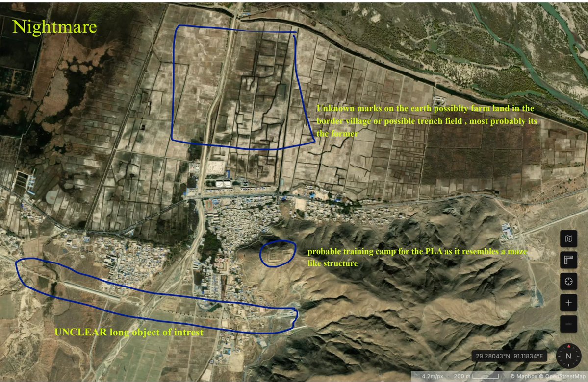
The final fourth image 74J9+58G Jiedexiuzhen, Gonggar County, Shannan, Tibet, China , this is termed as a residential committee by China which is basicallhy another border town / village and what intrested me is the trench like structures present here , although present next to what looks like farmland , this does look like a trench replica maybe used for training( i may be wrong) and also we can see a possible PLA camp/training site in the small hill (my best guess) also the final intresting structure aside from the houses are the long transmission/pipeline like structures that go into the hill ( this is very very intresting as the structure goes on outside the sat image frame also) .
I will keep posting more satellite images whenever i get more time as the border buildup along the Indian Border is a case of high intrest for me be it civilian infrastructure or military or be it dual use structures , i can one thing for sure China has built up far more than India has in its side and India needs lots of catching up to do which i think India can do with limits ofcourse.
Stay tuned for more and if possible RT this if you find it intresting .
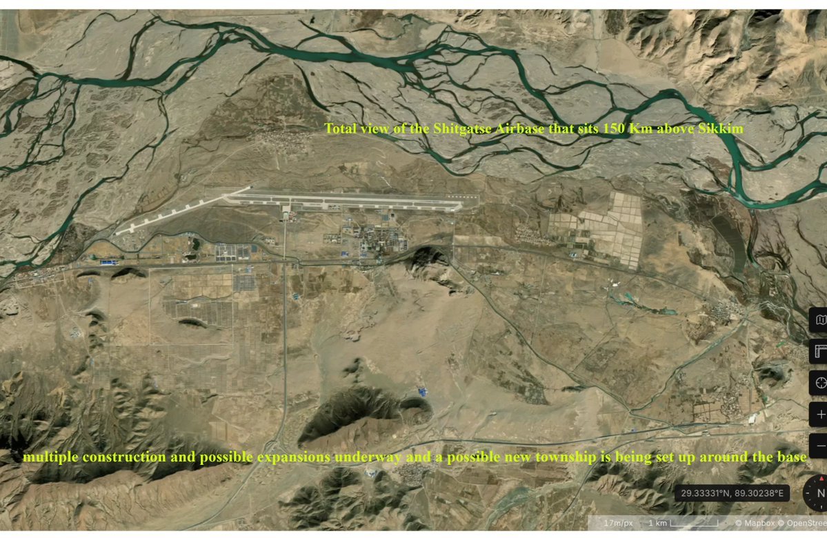
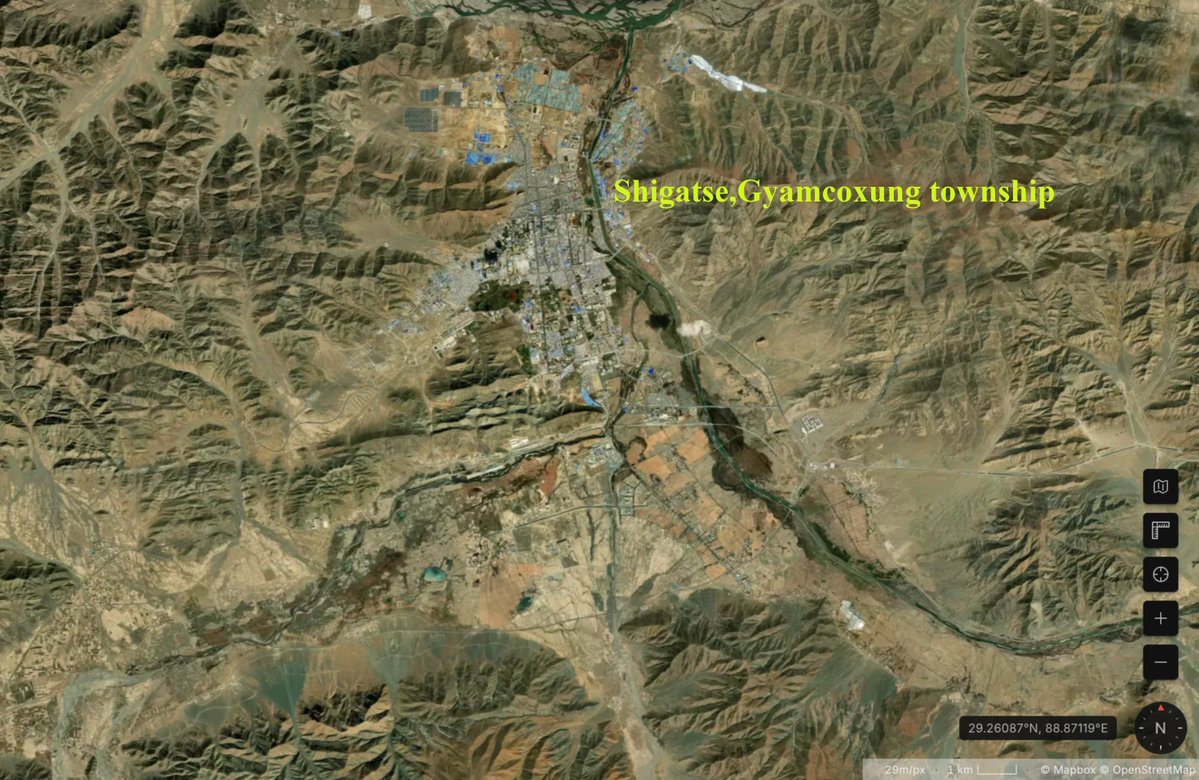
New set of Satellite Images of the Chinese Buildup along Indian Border , this is quite alarming if you look from the perspective of India as chinese buildup keeps on going up and up while Indian Buildout remains extremely lack lusture , nonetheless we will look at a very intresting portion of the buildup which is the famous Shigatse base and the surrounding areas.This base is crucial as it lies above the state of Sikkim and overlooks the Siliguri coridor.
1)From area of 87XF+VR5 Jiangdangxiang, Samzhubzê District, Shigatse, Tibet, China this is the infamous Shigatse "peace" airport as coined by the Chinese Government but in reality its a PLAAF military base known as Shigatse Airbase , and let me be clear the amount of buildup in and around this base and the Samzhubze district is extremely impressive as well as alarming (over the years we can see whole towns and villages being built up along with the most important infrastructure -Railways , massive highways , Industries(YES , i mean it) as well as Defence ecosystem )now this first image shows the helipads of Shigatse airbase with many PLA helicopters stationed , this is the most usual air vehicle in this base as they regularly conduct training flights , we can also see visible construction going on around the base (see-29.34963°N, 89.27462°E although i would advise not to use G Earth but apple maps or Pixxel/Vantor).
2)more of the Airfield from Shigatse , tha base has temporarily hosted the 5th Gen J-20s during 2024 but its not permenent . the most common fighters you find here are J-11/J-16s along with J-10C sometimes, here in this image we can clearly see J-11/J-16 fighters belonging to the PLAAF and we can also see possible new construction activity for quarters (29.35087°N, 89.30555°E)
3)Third Image is the overall SAT IMAGE from Shigatse , whats intresting in this Pic is the amount of farming like activity around the base suggesting heightened human activity as this also corelates to heightened construction activity we caqn see (more houses being built , more personnel quarters being constructed , Notice the Highways around the Base and the setrlements and the chinese are even more prepared with Rail line - these things only mean one thing LOGISTICS and remember these infrastructure are incredibly useful for economic engine and can be flipped in case of a war or conflict to act as a military node )29.35087°N, 89.30555°E
4)Now this is a little far from the Airfield but this points to my logistics point , we can see highways and raillines connecting and moving beyond this town (7V6C+8FW Chengnan Subdistrict, Shigatse, Samzhubzê District, Shigatse, Tibet, China), this is the Chengnan district and compare this new satellite image below to the Google Earth image (Massive differences and heavy construction activity), this town is such an intresting spot and fairly speaking i will post another breakdown related to this town itself , now to be brief this town gets connected by the same railline/highway from Shigatse airbase .
I will post another set of Imagery today , Please RT and follow if you are interested in these developments
I have observed recent construction and military activity of the PLA(People's liberation Armed forces) across the Indian/Nepal border and lets say they are extremely intresting .
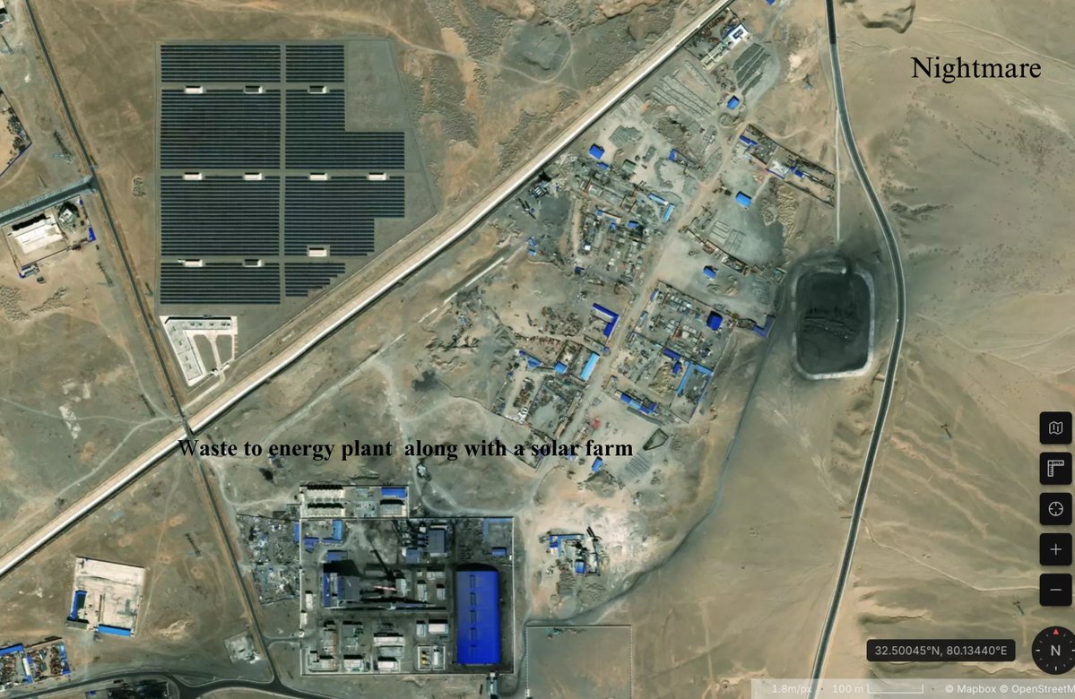
The first image is from G42M+5QJ Shiquanhe, Gar County, Ngari Prefecture, Tibet (32.50045°N, 80.13440ºE though not updated in google maps with this latest imagery) we can see a huge town in the middle of a valley and it has a solar farm present next to quite a large Waste to power plant (my best guess), we can also see lots of construction activity going on around this structure .
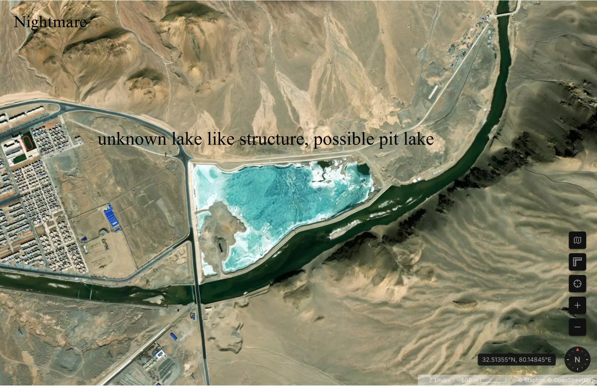
The second image is from the same area just a little upwards a dam is present though not seen in the image but whats more intresting is below the dam we can see a pit lake sort of area (again not updated in G earth its just a mud pit there) , and we can see the town spreading till here .
Third image is south of Gar county (32.42814°N, 79.99714°E) and shows a structure that looks like a maze which might be a PLA training camp with structures built using sandbags or bricks , right outside this frame i noticed a huge camp quarters possibly for the troops .
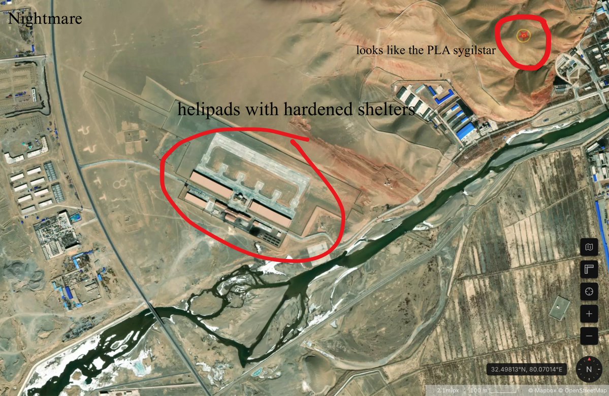
Fourth Image is again from F3XC+732 Shiquanhe, Gar County, Ngari Prefecture, Tibet, China(32.49813, 80.07014) and we can see multiple helipads with hardened shelters , this is located at the western end of the town/county but what catches my eye is this intresting symbol on the ground which resembles the PLA star/emblem on the top right of the image (can anyone tell what this exactly is).
I will look more into the buildup along the Indian border as this is vital knowledge to see whats going on in the otherside , i will try to upload more images as soon as possible .
Images sourced from Sentinal satellite aswell as Google Earth is used for reference (this is outdated).
Additionally , below the bse in farming settlements we can see possible sandmining taking place in the desert and above that we can see an unknown struture , i say its a possible SAM system likely the HQ9 which is permenently stationed near Hotan airbase
Multiple J7 fighters that are decommissioned can be seen , Hotan hosts multiple of these fighters also called graveyard , speculations float that the PLAAF is considering converting them to UAVs but these are unconfirmed
Multiple J7 fighters that are decommissioned can be seen , Hotan hosts multiple of these fighters also called graveyard , speculations float that the PLAAF is considering converting them to UAVs but these are unconfirmed