From the moment I first gazed toward the heavens, I have been infatuated with the weather. From the way clouds transform the sky to the quiet of a midwinter snow to the awesome power of a hurricane, I knew that weather would always be part of my life.
As the father of an autistic child, life has thrown more than a few curveballs my way. But it has also taught more than a few lessons.
Determination, forbearance, forgiveness, and humility are not easy lessons to learn, but life continues to shower me with opportunities to do so, and I continue to try and learn them.
Until recently, I have not had time to fully pursue my passion for the weather. Now I can. I hope to share that with you at this time and in this space.
Thank you for supporting me and for spending your time enjoying the wonderful world of weather with me.
I'm blessed to be here, and only by the grace of God am I able to do this. And there are more exciting things to come, so stay tuned!
Something BIG is coming! Plus severe weather is likely in the East today and in the heartland again tomorrow. Strong winds and hail are the primary threats today and add tornadoes tomorrow. Catch the latest in today's video:
https://t.co/d87LONFOaO
The severe weather pattern isn't letting up! ⛈️ Today we’re watching a significant wind risk for the Eastern Seaboard and a developing system out West. After a week with over 50 tornadoes, it’s important to stay weather-aware. Check out the latest timing and radar analysis here. Stay safe! 🌪️ https://t.co/enb8Z2iCAE #SevereWeather #WeatherUpdate #StaySafe #StormChasing
⚠️ SEVERE OUTBREAK ALERT: Today is a significant severe weather day for the Midwest.
My latest analysis is showing a major tornado and hurricane-force wind threat (45% probability) for the Chicago/Davenport corridor, peaking between 3PM–8PM.
Full technical breakdown: https://t.co/3v3YhTmRUY
#SevereWeather #TornadoThreat #WindRisk #ChicagoWX #TimEalerWX
A Moderate Risk (Level 4) of severe weather is now in place for northern IL and eastern IA, including, Chicago, Peoria, Cedar Rapids, and Iowa City. Strong to intense tornadoes are possible, along with destructive winds and large hail.
A bow echo is moving through this morning, and strong instability will occur with afternoon heating in the wake of the morning system, as moisture recovery takes place. Supercells will eventually form into a rapidly advancing line, capable of winds of over 75 mph. EF3 tornadoes will be possible with supercells this afternoon.
Stay weather aware through the day if you live in and around these areas.
Severe weather will also be possible in parts of the east later today as well.
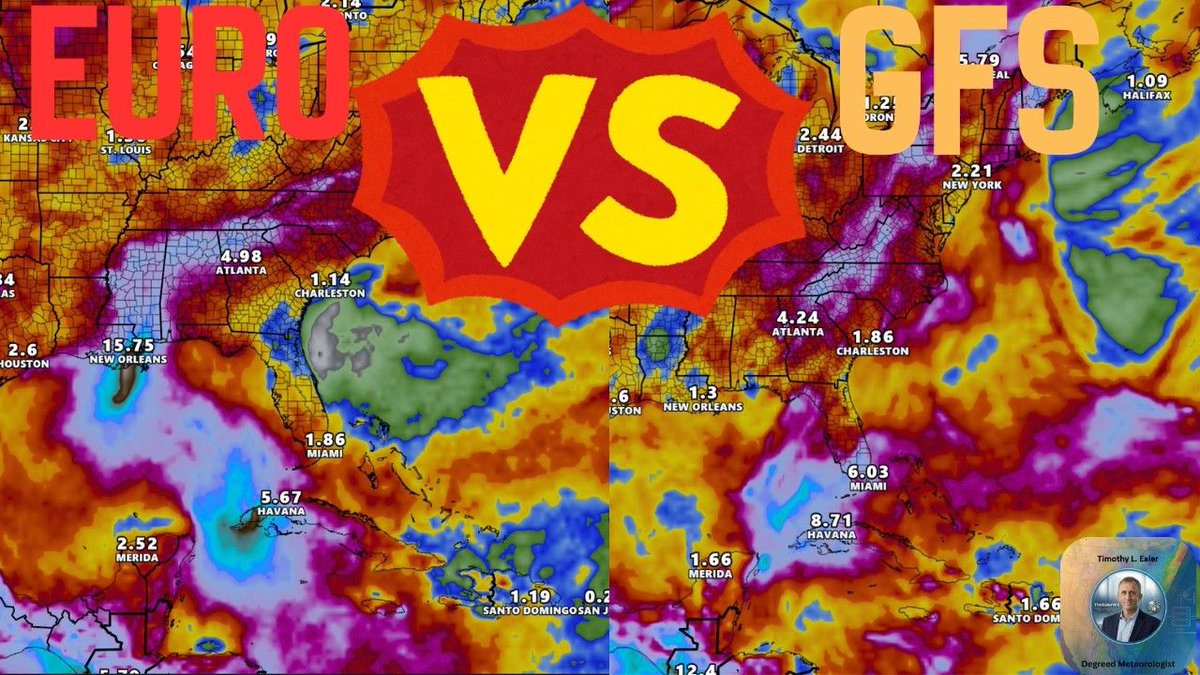
🌀 Model War in the Gulf! ⚔️ The Euro model is hinting at a nightmare rainfall scenario for the Gulf Coast, while the GFS remains skeptical. Who will be right?
I’m breaking down the latest ensemble data and what residents from LA to AL need to know.
Watch the full update here: https://t.co/jJzwJSBQgA
#WeatherUpdate #HurricaneSeason #GulfCoast #NHC
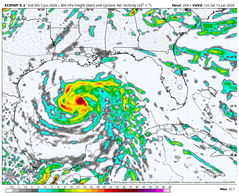
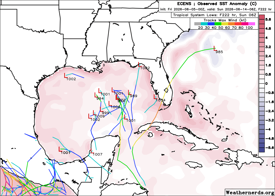
We continue to have a signal from some model guidance showing a tropical spin around the day 7-10 timeframe. Below is model data from the Euro & EPS. We will see if the signal increases or decreases over the weekend. There will be a window of opportunity for this to work out.
I think regardless, the pattern supports a tug of tropical moisture to the North. This could bring tropical rains into the Gulf & Southeast states. Watching for now.
Comments like this really mean the world to me. Sometimes this job can feel like you’re just talking to a camera. It’s always refreshing to be reminded why I do what I do ❤️
The models love to bring tropical cyclones into the US at range. Both the EURO and GFS are doing it right now. This is something we're probably going to have to deal with all summer. Be discerning.
A Severe Thunderstorm Watch is up until 7:00 PM CT. Already seeing warnings as this line takes shape.
Look for outflow-driven convection and southward linear propagation producing swaths of severe winds through the afternoon.
@cars0000n I don't know man...the stj isn't looking optimal for now, and we have a big ridge ultimately looking to get going in the middle of the country...also not ideal.