AMS #1682 NBC Bay Area since 2003, SJSU Meteorology lecturer, NASA SSA. Formerly KIRO, KCRA, KSBY, KESQ, KNBC, Arizona Daily Wildcat+twinado dad 👦🏻🌪️👦🏻🌪️
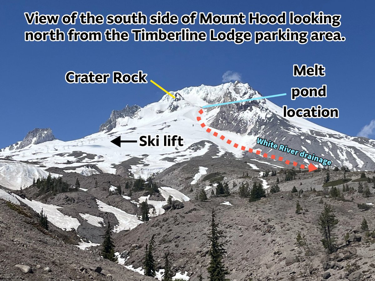
USGS Cascades Volcano Observatory scientists performing a routine helicopter observation flight at Mount Hood noticed that a seasonal meltwater pond at the base of the Coalman Glacier was significantly larger than in previous years. The pond lies in a basin bounded by Crater Rock, cliffs extending down from the summit, and Devil’s Kitchen, an earthen berm composed of hydrothermally altered rock and glacial moraine material. Devil’s Kitchen is a long-lived feature and appears stable based on current observations.
The pond’s water volume is unknown but is estimated to be on the order of ~50,000 cubic meters, roughly equivalent to 20 Olympic-sized swimming pools. A water sample collected last week had a provisional measured pH of 4, which is similar to the pH of black coffee, indicating mildly acidic conditions.
If all the water were released suddenly, it could generate a debris flow down the White River with the potential to reach the Highway 35 bridge. Topography would prevent the flow from traveling down the Sandy River or toward Timberline and Government Camp. Based on current estimates of the pond’s water volume, impacts to populated areas are not expected.
USGS Cascades Volcano Observatory scientists are working with the U.S. Forest Service, the National Weather Service, Portland Mountain Rescue, and other agencies to make additional measurements and assess the stability of the meltwater pond. CVO will issue further updates as conditions warrant.
The Cascades Volcano Observatory update for Friday, October 23, 2026: All volcanoes in the Cascade Range of Oregon and Washington were at normal background levels.
Over the past week, there were small earthquakes detected at Mount St. Helens. Field crews conducted a gravity survey at Mount Hood, installed sensors at Spirit Lake near Mount St. Helens, and made improvements to monitoring stations at Mount Adams. Analysis of routine gas flight measurements at Mount Adams, Mount St. Helens, and Mount Hood indicate normal background levels of degassing.
📷 1: View of Mount Hood from the parking lot at Timberline looking north. From this vantage point, you can see the location of the melt pond and the White River drainage. Credit: H. Weiss-Racine
📷 2: The melt pond at Coalman Glacier as viewed from the USGS helicopter observation flight on October 6th, 2026. Credit: USGS
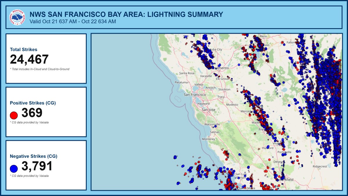
Mother Nature put on a wild light show! ⚡️ Over 24,000 total electrical discharges hammered our region over the past 24 hours. A fraction of the total actually reached the ground. CA has additional chc for lightning today. Thunder roars, go indoors!🌩️ #CAwx#Lightning
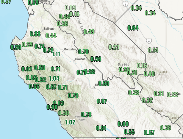
Now that the radar has been switched back into clear air mode, take a look at rain 🌧️ totals over the past 48 hours.
The big winners were definitely the Santa Lucia Range and the Santa Cruz Mountains. #CAwx
Anyone else start their day with a run 🏃and notice how warm it was? I sure did. 🥵 That’s offshore flow for you! Downslope winds pushed 7 AM temps into the upper 70s and 80s along the coast. Big Sur Coast at 86°F! It was pretty dry too. #cawx
Now that's a spectacular show! 🌋
Lava fountains light up the night sky at Kīlauea in Hawaiʻi Volcanoes National Park, offering a breathtaking glimpse of the powerful forces that continue to shape our planet.
Kīlauea Eruption Update — Episode 55 of lava fountaining!
After nearly two months since episode 54 of lava fountaining (Aug. 25, 2026), episode 55 of Kīlauea summit lava fountaining began at 3:19 a.m. HST this morning, October 17, and is ongoing. This is the 55th lava fountaining episode in the Kīlauea summit caldera eruption in Hawai‘i Volcanoes National Park that began on December 23, 2024. It occurs following weeks of intermittent spatter, low-dome fountains, and lava flows from the eruptive vent complex. The lava fountain from the north vent reached an estimated 700 feet high above the vent around 5 a.m. Hawaii Standard Time. The eruptive plume is reaching an estimated 25,000 feet above sea level. According to the National Weather Service, winds are blowing from the north-northeast direction, which suggests that volcanic gas emissions and volcanic material may be distributed to the south-southwest.
Fountaining episodes typically last 12 hours or less, but ash can remain in the air for longer depending on wind and weather conditions. Please stay aware of hazards and rely on official updates from USGS, National Weather Service, and Hawai’i Volcanoes National Park. 🎥 Video of episode 55 on October 17, 2026. #Kilauea #Eruption #Lava
🚨 TRAFFIC ALERT: HENDERSON FIRE 🚨
As of 5:13 PM, ALL NORTHBOUND AND SOUTHBOUND of I-5 are OPEN!
The freeway closure is fully lifted.
Thank you for your continued patience.
🚨 TRAFFIC ALERT | HENDERSON FIRE 🚨
As of 1:40 PM, smoke is affecting visibility along both sides of the freeway.
I-5 remains FULLY CLOSED in both directions between Vandergrift Blvd. and Basilone Rd.
Avoid the area and use alternate routes
#BakerFire - UPDATE -
The fire is approximately 10 acres, and 5% contained. Air and ground resources are making good progress and continue working on increasing containment on this incident.
Post-flight analysis confirms the Artemis II Orion heat shield performed as expected during its Mach 39 reentry, protecting the spacecraft and the astronauts aboard as they returned from the 694,481-mile journey around the Moon. https://t.co/lfibBY6AQc
10/13/2026: Wild temp swings ahead first between our chilly mornings and Summer-like afternoons to wrap up the week followed by a cool down early next week which also brings rain chances #BayArea#NorCal
Potential for power safety shutoffs coming to the higher elevations of the North Bay and East Bay. Warmer temperatures, windy, and dry over the hills 10/14-10/17. 10/13/2026