Daily storm chances continue through Memorial Day weekend and into next week with a low heavy rain threat. If you have lake or outdoor plans, keep an eye on the sky and have a way to receive alerts. Be ready to seek safe shelter if a storm approaches! 🚤⚡ #dfwwx#ctxwx#txwx
Most areas stay rain-free today before scattered storms move in from the west late this evening (after ~10 PM), mainly near and north of I-20. ⛈️ The severe threat is low, but a few storms could become strong mainly with gusty winds. #dfwwx#ctxwx#txwx
Showers and storms return to the region late tonight and Thursday. The main threat with any storm is isolated flooding, but a few stronger storms could also produce frequent lightning, small hail, and gusty winds. Remember, never cross flooded roads! #dfwwx#ctxwx#txwx
A broken line of storms along and behind a cold front will continue to push south across North and Central Texas through the remainder of today. Although the severe threat is on the lower end, isolated damaging wind gusts and hail will remain possible through this evening. #txwx
Showers and storms arrive along a cold front today, a few of which may become severe with large hail and damaging winds. Storms should exit late evening with a mostly quiet night to follow. Stay weather aware! #dfwwx#ctxwx#txwx
There is a less than 20% chance of isolated strong to severe storms this afternoon. If storms are able to develop, hail is the main risk. Otherwise, it will be a warm, humid, and breezy afternoon. Expect winds around 20 mph with gusts to 35 mph to continue.
Mostly cloudy and cooler weather is expected today with a few passing showers and isolated storms. Some of the elevated storms may produce some hail, but the overall threat for severe weather is lower for our area.
Also, here's the forecast as we end the work week. #dfwwx#ctxwx
A cold front is still expected to arrive today with a few showers and storms late afternoon and evening. Here's the latest on what to expect through tomorrow and the areas that could see some of this activity. A few strong to severe storms are possible. #dfwwxx#ctxwx#txwx
Showers are expected to persist today, with Central Texas having the highest probability of rain. While severe weather is not anticipated, isolated strong storms capable of producing heavy rain, frequent lightning, and small hail are possible. #ctxwx#dfwwx#texomawx
Scattered showers and thunderstorms are expected throughout the day today, mainly along and south of I-20. The severe threat is low, but a few storms may produce hail, frequent lightning, and locally heavy rain. #texomawx#ctxwx#dfwwx
Storms are expected today!⛈️Outdoor Warning Sirens (OWS) alert people outdoors. In Dallas, they are activated for tornado warnings, winds of 70+ mph, or hail over 1.5 inches.
Today’s storms may produce large hail and damaging winds. If you hear sirens, seek shelter immediately.
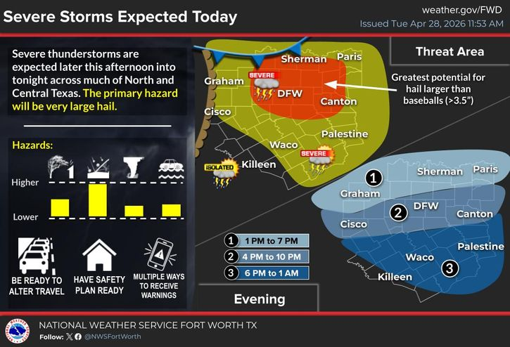
Severe thunderstorms are expected today across much of North and Central Texas. Large hail greater than baseballs will be the primary threat. Be weather aware and have multiple ways to receive warnings! Stay safe today y'all!
Isolated to scattered severe storms are expected across North Texas early this evening, with the greatest threat north of I-20. Not everyone will get storms, but those that do will have a threat for large to very large hail, damaging wind gusts, and tornadoes. #dfwwx#txwx
Isolated severe storms are forecast both Saturday and Sunday, primarily along/north of I-20 and along/east of I-35. However, most locations will remain dry! The primary hazards will be isolated large hail and damaging wind gusts, with a lower threat of tornadoes.