🚨 Damaging Storm Near Harrison, NE
Severe thunderstorms with large hail and damaging winds are occurring in parts of Nebraska and Wyoming. These storms pose risks of injury, property damage, and possible tornado development requiring immediate shelter.
📍 Area: Box Butte, NE; Dawes, NE; Sioux, NE; Goshen, WY; Niobrara, WY
⚠️ Threat: 60 MPH wind
🕒 Expires: Jun 22, 8:15 PM CDT
#severeweather #weather
🌧️ Isolated flash flooding in western North Dakota
Thunderstorms will train northeast across western North Dakota this evening with 1-2 in/hr rates and 2-4 inches possible. Isolated flash flooding may occur where storms repeatedly track.
Rainfall: 1-2 in/hr
Totals: 2-4 inches
Timing: This evening, tapering near midnight.
#ndwx #flooding #weather
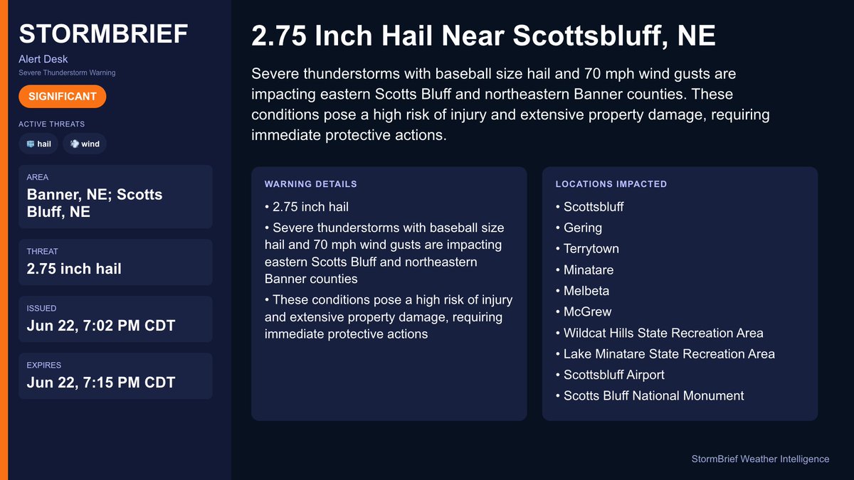
🚨 2.75 Inch Hail Near Scottsbluff, NE
Severe thunderstorms with baseball size hail and 70 mph wind gusts are impacting eastern Scotts Bluff and northeastern Banner counties. These conditions pose a high risk of injury and extensive property damage, requiring immediate protective actions.
📍 Area: Banner, NE; Scotts Bluff, NE
⚠️ Threat: 2.75 inch hail
🕒 Expires: Jun 22, 7:15 PM CDT
#severeweather #weather
🌩️ Damaging winds in Mid-Atlantic line: Portions of the Mid-Atlantic Coastal States
A bowing line of storms in the Mid-Atlantic is producing 55-70 MPH wind gusts. A brief tornado or two is possible before storms move offshore soon.
Threat: Damaging winds
#severeweather
📝 North Alabama / Southern Middle Tennessee: Severe storms this evening; wind/tornado risk
Severe storms with damaging winds, heavy rain, and a low tornado risk continue this evening, then turning drier Tuesday before rain chances return midweek.
🌡️ Tuesday lower 80s
🌧️ 40-60% Wed-Thu
⏰ 3-11 PM today
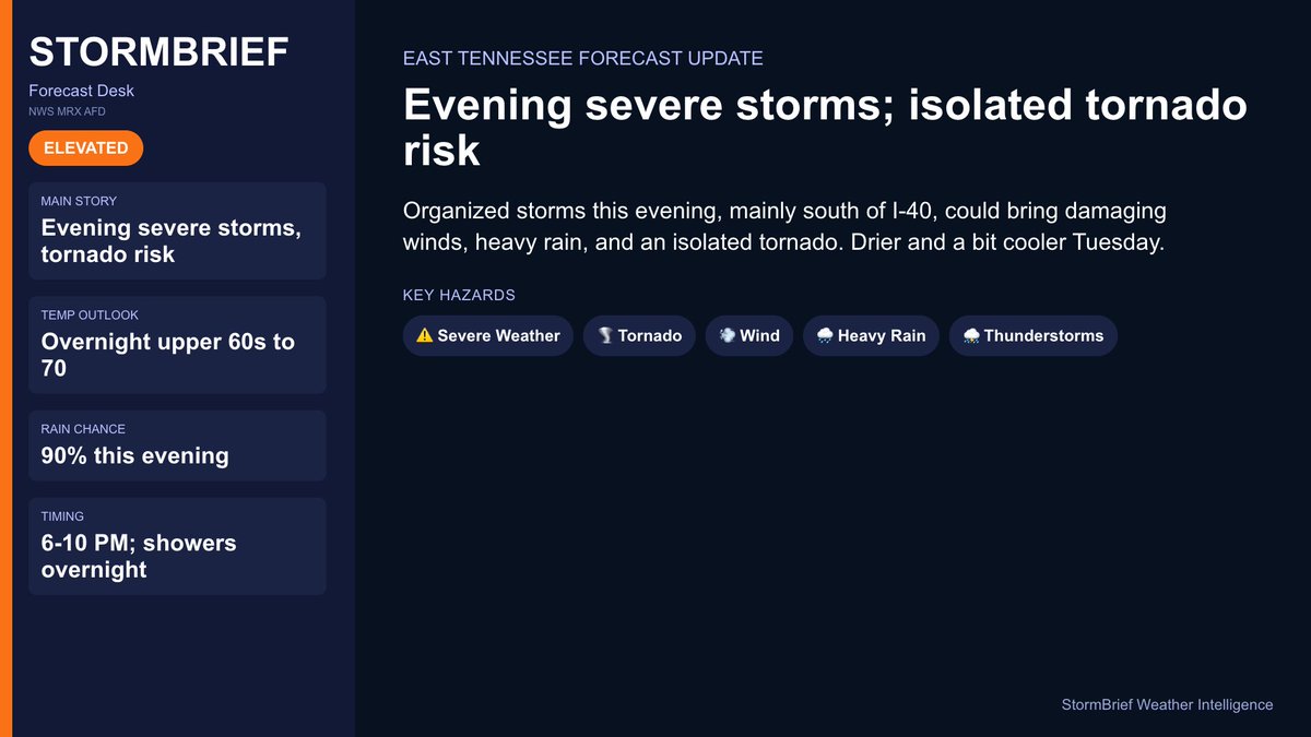
📝 East Tennessee: Evening severe storms; isolated tornado risk
Organized storms this evening, mainly south of I-40, could bring damaging winds, heavy rain, and an isolated tornado. Drier and a bit cooler Tuesday.
🌡️ Overnight upper 60s to 70
🌧️ 90% this evening
⏰ 6-10 PM; showers overnight
📝 West Tennessee / North Mississippi: Evening severe threat til ~10 PM; cooler Tue, storms Wed, heat late week
Severe storms and heavy rain wind down by around 10 PM, then cooler and quieter Tuesday. Another disturbance may bring storms Wednesday, with heat building late week.
🌡️ Tuesday 80s
🌧️ <30% Wed severe
⏰ This evening; Wed morning
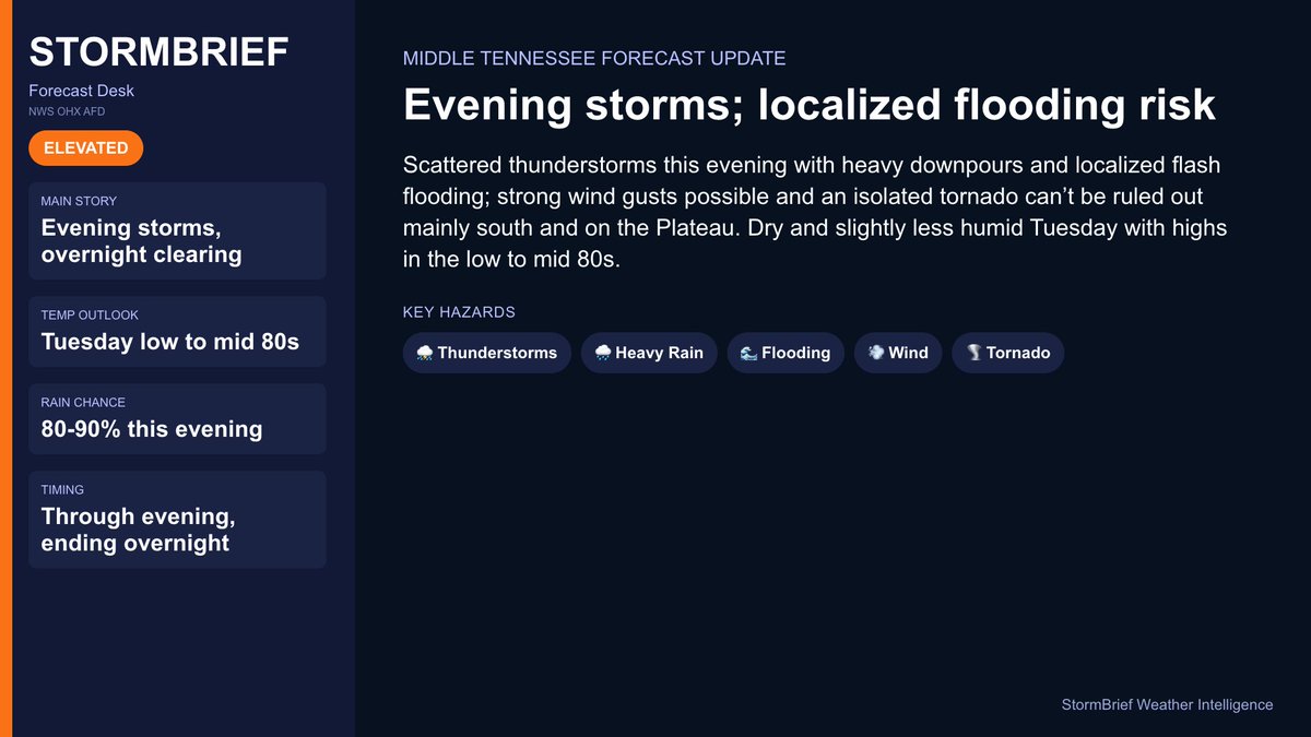
📝 Middle Tennessee: Evening storms; localized flooding risk
Scattered thunderstorms this evening with heavy downpours and localized flash flooding; strong wind gusts possible and an isolated tornado can’t be ruled out mainly south and on the Plateau. Dry and slightly less humid Tuesday with highs in the low to mid 80s.
🌡️ Tuesday low to mid 80s
🌧️ 80-90% this evening
⏰ Through evening, ending overnight
🚨 Damaging Storm Near Van Tassell, NE
Severe thunderstorms with 60 mph wind gusts and large hail are occurring near Van Tassell in Sioux, NE and Niobrara, WY. Expect hail damage to vehicles and wind damage to roofs, siding, and trees with possible tornadoes.
📍 Area: Sioux, NE; Niobrara, WY
⚠️ Threat: 60 MPH wind
🕒 Expires: Jun 22, 7:30 PM CDT
#severeweather #weather
🚨 2.75 Inch Hail Near Scottsbluff, NE
Severe thunderstorms with baseball size hail and 60 mph wind gusts are impacting Scotts Bluff and nearby areas. People outdoors face severe injury and extensive property damage is expected, with a possible tornado threat.
📍 Area: Banner, NE; Scotts Bluff, NE; Sioux, NE
⚠️ Threat: 2.75 inch hail
🕒 Expires: Jun 22, 7:15 PM CDT
#severeweather #weather
🌩️ Isolated severe hail in eastern Colorado: eastern Colorado
Isolated severe thunderstorms continue across eastern Colorado. Large to very large hail is the primary hazard this afternoon into early evening.
Threat: Large hail
#cowx#severeweather
🚨 Confirmed Tornado Near Fowler, CO
A damaging tornado is occurring in the Fowler area and surrounding counties. Flying debris and structural damage are expected, posing immediate danger to life and property.
📍 Area: Crowley, CO; Otero, CO; Pueblo, CO
⚠️ Threat: Damaging tornado
🕒 Expires: Jun 22, 7:15 PM CDT
#tornado #weather
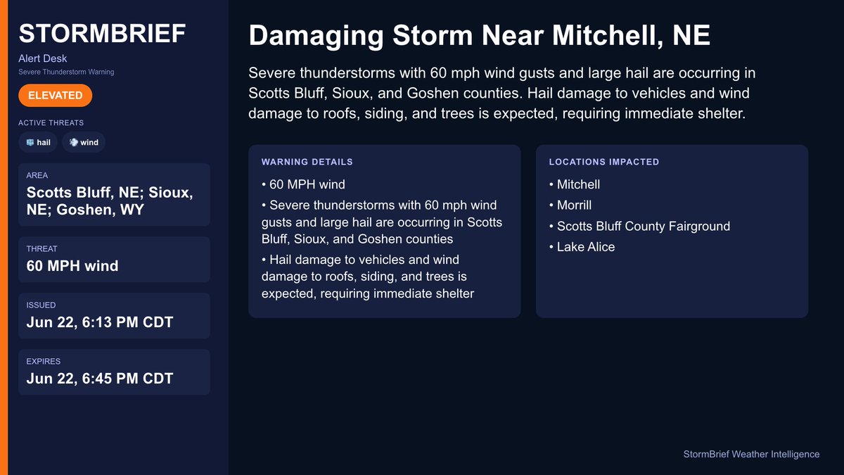
🚨 Damaging Storm Near Mitchell, NE
Severe thunderstorms with 60 mph wind gusts and large hail are occurring in Scotts Bluff, Sioux, and Goshen counties. Hail damage to vehicles and wind damage to roofs, siding, and trees is expected, requiring immediate shelter.
📍 Area: Scotts Bluff, NE; Sioux, NE; Goshen, WY
⚠️ Threat: 60 MPH wind
🕒 Expires: Jun 22, 6:45 PM CDT
#severeweather #weather
🚨 3 Inch Hail Near Sterling, CO
Severe thunderstorms with destructive three inch hail and 60 mph wind gusts are impacting southwestern Logan County, CO. People and animals outdoors face severe injury and expect extensive property damage.
📍 Area: Logan, CO
⚠️ Threat: 3 inch hail
🕒 Expires: Jun 22, 6:30 PM CDT
#severeweather #weather
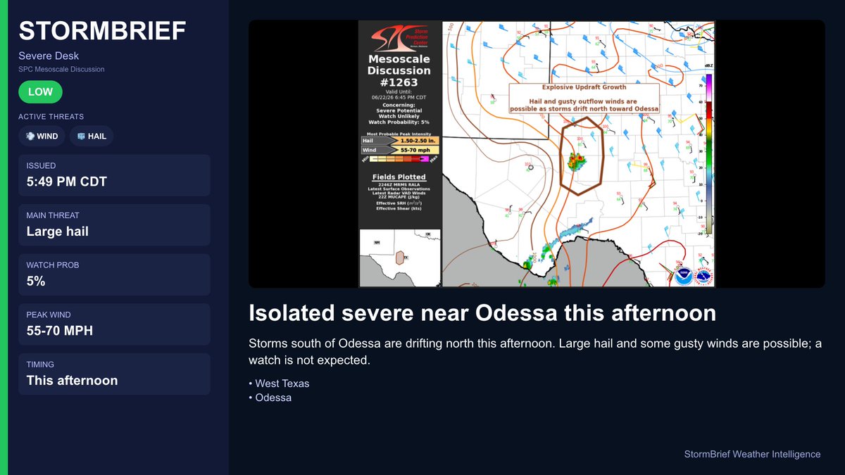
🌩️ Isolated severe near Odessa this afternoon: West Texas & Odessa
Storms south of Odessa are drifting north this afternoon. Large hail and some gusty winds are possible; a watch is not expected.
Threat: Large hail
#txwx#severeweather
🚨 80 MPH Winds Near Tongue River Reservoir, MT
Severe thunderstorms with destructive 80 mph winds and 2 inch hail are impacting southeastern Big Horn County, MT and eastern Sheridan County, WY. Flying debris and heavy damage to mobile homes, roofs, windows, and vehicles are expected with likely power outages.
📍 Area: Big Horn, MT; Sheridan, WY
⚠️ Threat: 80 MPH wind
🕒 Expires: Jun 22, 6:45 PM CDT
#severeweather #weather
🚨 Damaging Storm Near Sioux County, NE
Severe thunderstorms with golf ball size hail and 60 mph wind gusts are occurring in west central Sioux and east central Goshen Counties. These conditions pose risks of injury and damage to roofs, siding, windows, vehicles, and trees, requiring immediate shelter.
📍 Area: Sioux, NE; Goshen, WY
⚠️ Threat: 60 MPH wind
🕒 Expires: Jun 22, 6:00 PM CDT
#severeweather #weather
🚨 3 Inch Hail Near Sterling, CO
Severe thunderstorms with destructive three inch hail and 60 mph wind gusts are occurring in Logan, CO. People and animals outdoors face severe injury and expect extensive damage to property.
📍 Area: Logan, CO
⚠️ Threat: 3 inch hail
🕒 Expires: Jun 22, 6:00 PM CDT
#severeweather #weather
🌩️ Isolated Severe Hail in Eastern Colorado: Eastern Colorado
Isolated severe storms are ongoing across eastern Colorado. Large to very large hail is the primary hazard this afternoon.
Threat: Large hail
#cowx#severeweather
⚠️ Severe Thunderstorm Watch Issued: Northern North Carolina, Central North Carolina, Southern Virginia
Strong to severe thunderstorms will move east across the watch area this evening with wind gusts up to 65 mph and isolated hail to 1 inch. The wind damage threat will likely diminish by late evening.
Threat: Wind
Wind: 65 MPH
Hail: 1 inch
#ncwx #vawx #severeweather