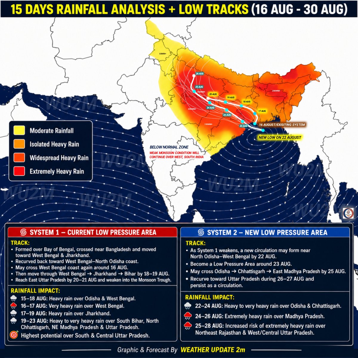
Bay of Bengal Low to move inland from 23 Aug.
🌧️ Very Heavy Rain: Odisha, Chattisgarh Madhya Pradesh
🌩️Heavy Rain: Jharkhand, Chhattisgarh & Central/South UP
🌦️Limited impact: Rajasthan, NW India; ☀️Break Monsoon over South & west India 👇🏻
#weather#rain#monsoon#wu2m#flood
TWO SYSTEMS, TWO RAINFALL SPELLS!
current LPA may be followed by 2nd system around 22–23 AUG, with the 2 systems potentially bringing heavy to extremely heavy rain from East → Central → North West India through 28 AUG. 🌧️ Full Info 👇🏻
#weather#wu2m#rain#furry#15août
🔴 System 1: West MP - weakening by 13 Aug, but may bring very heavy rain over SW MP Etc!
🌀 System 2: Circulation near the N Bob near Bangladesh, may develop into an LPA by 11 Aug and move WNW,
ALERT - 10–18 August. Check Full Info 👇🏻
#weather#rain#wu2m#gooner#nsfwtwtًً
🚨 No Major Monsoon System Till 22 August?
🇮🇳 India's 15 Day Rainfall Pattern (7–22 August)
🌧️ Heavy rain risk continues over Northeast India.
🌩️ Scattered thunderstorms expected across parts of Central & North India.
Check 👇🏻
#weather#rain#monsoon#quıck#paofc#wu2m
🌀 BOB 03 DEEP DEPRESSION - TRACK & RAIN UPDATE
Track: - 29 Jul → Chhattisgarh
30 Jul → Vidarbha, South MP, North Maharashtra
31 Jul–1 Aug → Gujarat & South Rajasthan
Check Graphic For Complete Info 👇🏻
#weather#rain#monsoon#flooding#wu2m#salı#Colón
New Bay of Bengal System to Hit Odisha on 28 July, Then Move to Rajasthan Guj by 1 Aug
Low may become Depression by 27 July.
Flooding rain in Odisha, Chhattisgarh, MP this week.
Guj/Raj rain likely 31 Jul - 3 Aug. Check Info 👇🏻
#wu2m#weather#rain#Algérie#HWCafe#flood
23–30 July Severe Weather Outlook
Two LPA are likely to bring widespread heavy to extremely heavy rainfall across Western & Eastern India.
⚠️ Highest flood risk:
📍 Gujarat & South Rajasthan
📍 Odisha & Chhattisgarh
#Monsoon#RainAlert#FloodAlert#wu2m#संसद_मार्च#Algérie
20–29 July Severe Weather Outlook: Gujarat Flood Risk & New Low Pressure Alert
⚠️ Back-to-Back Weather Systems May Trigger Flooding Rain Over Gujarat & Eastern India! Check Full Info 👇🏻
#weather#rain#monsoon#cyclone#wu2m#flooding
Potential Low Pressure System May Develop Over the North Bay of Bengal During the Next 24–36 Hours.
Model Ensemble guidance continue to indicate a possible cross near North Odisha–West Bengal around 15–16 July
👇🏻
#lowpressure#momsoon#rain#wu2m#VíasChile#tccandler#RadioXV
Latest model guidance suggests an unusual east recurvature after entering Uttar Pradesh, with rainfall likely to increase again over Bihar, Jharkhand, West Bengal, Odisha and nearby regions.. Check The Latest Graphical Outlook For More 👇🏻
#wu2m#monsoon#Origin#Belgium#rain
🚨 JULY 4–9 SEVERE WEATHER OUTLOOK
🌀 Possible BOB Depression around 5 July, Flooding Rains for East & Central & West coast!⚠️
🌊 Strong Monsoon Surge may also trigger flooding rain over South Gujarat, Mumbai & Konkan Coast ⚠️
Check Full Info.
#weather#rain#wu2m#nsfwtwtًً
• Low Pressure: 3/4 July
• Track: Odisha → Chhattisgarh → MP/UP
• Could be First Monsoon Low
• Heavy/V Heavy Rain: Odisha, Chhattisgarh & MP
• Very Heavy Rain: NE India & West Coast
Valid: 23 June - 7 July 2026
Check Full Info 👇🏻
#Wu2m#rain#salı#weather#tadc
🚨 Monsoon 2026 Seasonal Rainfall Outlook (Unofficial)
El Nino is strengthening! Below normal rainfall is likely across large parts of NW, West & Central India, while East and NE India may see normal to above normal rain..Full Info 👇🏻
#monsoon2026#rain#wu2m#salı#diddyleak
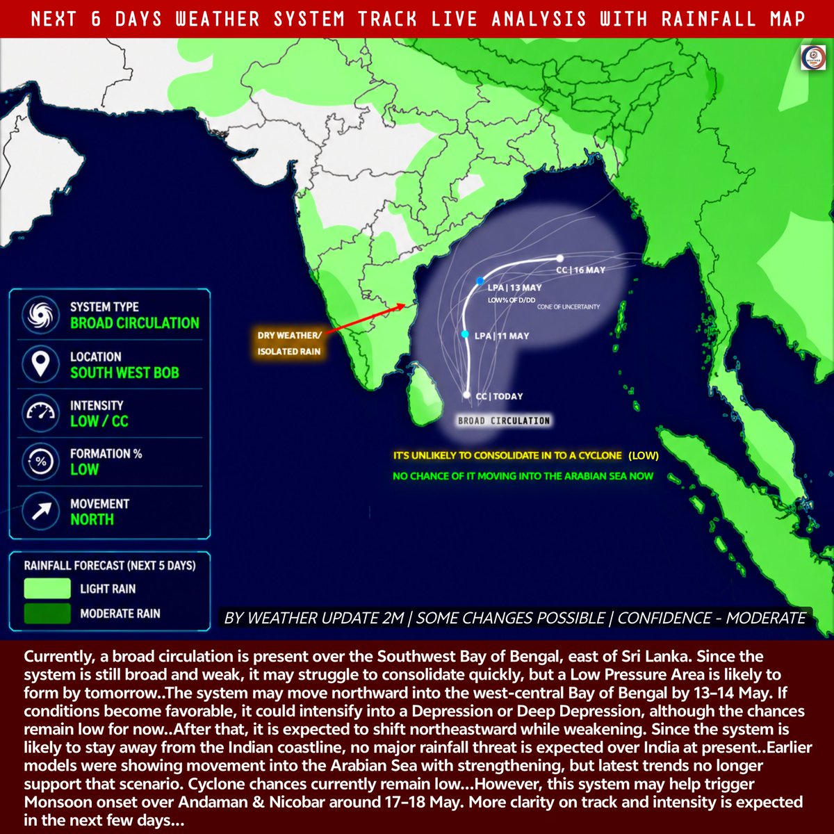
Southwest Bay of Bengal System Update: Broad Circulation Active East of Sri Lanka | Cyclone Chances Currently Low, But May Help Monsoon Onset Over Andaman & Nicobar! Latest Track, Check out.
#cyclone#storm#monsoon#şampiyon#Hantavirüs#wu2m
Possible System Near Sri Lanka | Track & Intensity Still Uncertain, Multiple Scenarios Ahead, Models Show Conflicting Signals! But Track Still Unclear! Heavy Rain Possible For South India Next Week.. Here Is Our Full Analysis..
#cyclone#weather#rain#çarşamba#fcmvff#wu2m
GFS AND AI-GFS ARE HINTING AT A WEAK DISTURBANCE OVER THE CENTRAL BAY AROUND 12 MAY, WITH IMPROVING BACKGROUND CONDITIONS. NOT A STRONG SYSTEM YET, BUT POTENTIAL FOR GRADUAL DEVELOPMENT EXISTS..
#cyclone#premonsoon#monsoon2026#łatwogang#brøndby#ŞAMPIYON#wu2m
Unofficial Monsoon 2026 Outlook 🌧️
Overall rain ~94% (±5%) → Slight Bel Normal
📊 NE: Above Normal
East: Normal
Central/West/South: Below Normal
North/NW: Mixed
El Nino Risk: Uneven rainfall floods in some areas, dry spells in others
#Monsoon2026#ElNino#wu2m#uşak#19Abril