Keeping A Watchful Eye On Goodhue County’s Weather. We are a group of trained severe weather storm spotters who report to the NWS Office in Chanhassen, MN.
7:15pm Radar Update: Scattered thunderstorm development is expected over the next few hours. A few storms may become strong to severe capable of producing large hail and damaging winds. Storms are moving to the northeast. #mnwx#wiwx
Our stretch of active weather continues through mid-week. An enhanced risk (level 3 of 5) includes S MN, portions of the Twin Cities, and W WI. Two rounds of severe storms are possible Wednesday: Morning 5-10 AM & Evening 6 PM to Midnight. Stay weather aware! #MNwx#WIwx
Hot and humid the next two days with heat index values in the 90s. This heat will setup storm chances on Tuesday night and Wednesday. Mainly a wind risk Tuesday night and all modes (wind, hail, tornado) possible on Wednesday. #mnwx#wiwx
Day 2 of Severe Weather Awareness Week begins with Lightning Safety!
We do not issue warnings for lightning, however all thunderstorms do contain lightning. When thunder roars, go indoors! More info at https://t.co/XH6qSzJFVO #mnwx#wiwx
It's Severe Weather Awareness Week for Minnesota and Wisconsin - how apt considering our chances for severe weather later today! Today is all about warnings and alerts so why not start things off with making sure you have multiple ways to get warnings? #SWAW26
Not only is it the start of Severe Weather Awareness Week, but it is also a day with a real severe weather threat. The Day 1 topic is Weather Alerts & Warnings.
Do you know the difference between a Watch and a Warning? More information at https://t.co/3kZNTIYKtK #mnwx#wiwx
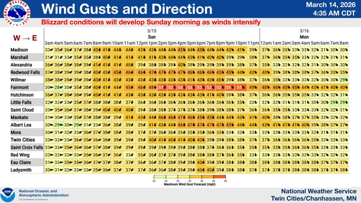
***MAJOR WINTER STORM THIS WEEKEND*** A Blizzard Warning has been issued for portions of western & southern MN. Heavy snow becomes widespread by this evening while northerly winds strengthen. Travel will be very difficult to nearly impossible by early Sunday morning. #mnwx#wiwx
Tonight is our final online spring SKYWARN Storm Spotter Training session taught by Sogn Valley SKYWARN. Class begins at 6:30pm and you must pre-register to get your access credentials. Visit our website at https://t.co/DgSIh0fIbK
Strong to severe storms are still expected tonight along a cold front, with a start time around 9pm in western MN moving eastwards quickly. See the attached image for timing details.
There is still uncertainty in the exact track based on where the cap is strongest. #mnwx#wiwx
Morning showers and storms across west central MN are forecast to weaken and give way to dangerous heat and humidity. Storms are then forecast to redevelop across the eastern Dakotas/central MN later today and persist into the overnight. Damaging wind and large hail possible.
Daily chance of thunderstorms through the weekend with heat increasing through Friday. The chance for strong to severe storms increases again Thursday and Friday. Storms most likely to form in the Dakotas and move into Minnesota. #mnwx#wiwx
Rain returns to the forecast tonight into tomorrow. The threat is low for severe weather, but we could see isolated instances of hail and wind with these two rounds of showers and storms. #mnwx#wiwx
We have the variables in place to produce winds in excess of 80mph, however not everyone who sees storms will see the peak strength. The greatest risk extends from SD into SW MN. #mnwx#wiwx
Strong straight line winds are possible this evening and early tonight.
Remember this...
1. Straight line winds can exceed 100 mph
2. Strong winds can knock over semi trucks, trees, powerlines, and lead to infrastructure damage
3. Wind damage can cover large areas