Matthew 25:40 -
Whatever you did for one of the least of these brothers and sisters of mine you did for me.
The best part about Me is I am not you,
I am Me.
My own evidence from my recent trip.
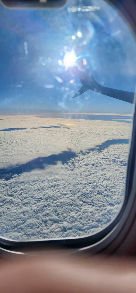
My photo below shows the Sun high in the sky with a hot spot directly below it on the clouds.
Strange for something that is said to be 109 times the diameter of Earth to have a hotspot below it🫢
I also got a video of the sun shining across a body of water, strange that the sun isn't lighting up the entirety of the body of water🫢
@griftdestroyer_@CalmLogical Real world data from experts on yacht racing in the south directly refute the globes claims.
Maybe stop believing what you read just because it plays to your bias🫡™️
Muhammad is still in his tomb.
Joseph Smith is still in his tomb.
Buddha is still is his tomb.
Confucius is still in his tomb.
But there is one man, who was not found in a tomb.
He was seen Alive by over 500+ eye witnesses, who wrote down accurate accounts of the man they saw hung up on the cross and they touched the scars.
Jesus is King, and he is Alive!🙌🏽✝️🙏🏽™️
@griftdestroyer_@CalmLogical https://t.co/3X50oKXdCy
That's the textbook theory, but real world telemetry from southern yacht racing proves otherwise. The actual logbooks and tracking show the distances expanding, meaning those lines diverge, not converge. The data speaks for itself 👇🏽🫡™️
The graticule was derived by looking up at the stars, not down at the dirt. Because our limit of vision extends equally in 360 degrees, our eyes naturally perceive a celestial sphere from any fixed position on Earth. When you map angular measurements against a curved optical dome, your coordinate lines will naturally form a spherical grid. That is a limitation of human perspective and optics, not proof of curved dirt roohif🫡™️
https://t.co/vjOyDHG1G5
I’m good, bud. I’ll stick to the actual field data from veteran blue water navigators and yacht racers down south who deal with real travel times, fuel consumption, and distances that expand the further south you go....the exact opposite of the northern.
Strapping a GoPro to a trundle wheel for a 1,000 meter walk on a local road doesn't debunk large scale maritime reality 😂
Your GPS unit is hardcoded with a WGS84 globe template from the factory, it literally cannot spit out coordinates that don't match its internal programming. You used a globe calibrated tool to get a globe calibrated reading and called it a discovery, wow roohif, just wow🤣™️
By definition, a 3D Cartesian coordinate system operates on three mutually perpendicular linear axes, evaluates positions using straight-line vector geometry, meaning it works entirely within a flat, three dimensional Euclidean space grid, rather than a inherently curved nonEuclidean geometry. It’s a plane coordinate system projected in three dimensions roohif.
The globe is not an aspect at all of actual reality🫡™️
@Roohyfnol@CalmLogical https://t.co/3X50oKXdCy
Hervé Riboni, a professional yacht racer has exposed your models claims of distances south of the equator.
Distances between points south of the equator are larger than your model allows.
You should get caught up🫡™️
@Roohyfnol@CalmLogical Nothing wrong with lat and long, they're derived from the stars, not Earth's geometry.
Maps don't prove Earth's shape is the point🫡™️
https://t.co/mQ0Wyfhni3
🗺️ Maps Aren’t Truth — They’re Tools
Every map is a projection.
Every projection introduces distortion.
And every mapmaker had a reason.
So let’s break down what each one really shows…
And why Gleason’s Map still stands unmatched 🧵👇🏼
1️⃣ Mercator Projection
🧭 Built for maritime navigation
📏 Accurate for local bearings and headings
❌ Grossly distorts landmass sizes on a wide scale
⚠️ Functional for direction at sea, not a model of reality
2️⃣ Mollweide Projection
🧮 Designed for area comparison
✅ Keeps landmass proportions accurate
❌ Warps shape, layout, and angles
📉 No good for travel or plotting
3️⃣ Robinson Projection
🎨 Made to look good
❌ Inaccurate for distance, shape, or area
📚 Used in classrooms, not by travelers
⚠️ Smooth visuals hide massive compromises
4️⃣ Winkel Tripel Projection
⚖️ Attempts to balance area, shape, and distance
✅ Better balance than Robinson
📏 Still distorted, not precise for route planning
📎 Use for general display only
5️⃣ Azimuthal Equidistant (AE)
🧭 Accurate direction and distance from center point
✅ Used in flight paths, HAM radio, UN iconography
📡 Distance stretches outward, but central scaling is true
🎯 Best for direct-line plotting and signal range
6️⃣ Goode’s Homolosine
📚 Designed for visualizing land data
💥 Breaks up oceans entirely
❌ Not usable for travel, plotting, or real-time info
🧩 For land distribution graphics only
7️⃣ Gleason’s Map (1892)
🕰️ Patented time and longitude calculator
✅ Measures longitude by Sun’s position
✅ Matches 60 nautical miles = 1° = real celestial geometry
🌞 Tracks Sun path, seasons, and time zones
🧭 Built on angular logic, not model assumptions
“The map is arranged to rotate in such manner that the sun’s position over the Earth may be represented, thus determining time at any point.”
📊 Accuracy by Function
Let’s break them down by purpose, local utility, and wide-range accuracy:
Mercator
✅ Local travel
❌ Large-scale distortion
🔧 Purpose: Compass and headings at sea
Mollweide
❌ Local use
✅ Area representation
📊 Purpose: Landmass proportion charts
Robinson
❌ Local or broad accuracy
🎨 Purpose: Visual simplicity
Winkel Tripel
✅ General balance
⚖️ Purpose: Display and politics
Azimuthal Equidistant (AE)
✅ Distance/direction accuracy from center
📡 Purpose: Navigation, signal, official icon
Goode’s Homolosine
✅ Local land stats
❌ Cohesive view
🧩 Purpose: Thematic data
Gleason’s Map
✅ Local & angularly accurate
✅ Matches celestial mechanics
🧭 Purpose: Timekeeping, navigation, solar tracking
Gleason Map overview:
https://t.co/0Azs59F2l5
🧠 The Takeaway
Maps are not absolute.
They’re filtered lenses for specific functions.
The best ones don’t assume a shape.
They reference the sky.
✨ Time = Sun’s circuit
✨ Navigation = Celestial angles
✨ Latitude = Polaris elevation
✨ Distance = Star-based nautical measures
🌐 The ground doesn’t spin.
📏 The sky is the clock.
🧭 Gleason mapped it from above.
#MappedFromTheSky
#GleasonWasRight 🕰️
#FlatEarthNavigation
#StarBasedSystem ✨
#LongitudeLogic
#DitchTheDistortion 🗺️
#TrustTheSkyNotTheSpin 🧭✌🏼™️
@alexboge@TheGlobeIsDead That measurement is true.
What the ring laser gyro doesn't tell you is the cause🤓
Your position believes it to be the earth....without evidence it is the Earth✌🏼™️
Many globe believers still think that the Netflix documentary Behind the Curve proved him wrong.
The documentary misrepresented Knodel’s interpretation of the experiment through selective editing and framing.
Once again, people accept what they are told by television without critical examination, becoming victims of deceitful propaganda.