TRFD is a 100% volunteer fire department in the City of Stamford. We broadcast local emergency incidents, weather updates, and safety messages to our followers.
We honor members of our armed forces who lost their lives protecting the freedoms afforded to us as American citizens by our founding fathers. If it were not for their sacrifice and all who sacrificed before them, the United States of America would not be the place it is today. May our heroes rest in eternal peace. #TRFD #CTfire
Weak low pressure will pass over the area late tonight into Wed morning bringing a period of light snow to the region. Some snow may mix with rain across parts of LI after sunrise. Snowfall totals will remain between 1 and 2 in. Drier conditions are expected in the afternoon.
A light snowfall is expected late tonight into Wednesday morning. 1" to around 2" is expected across S CT, the Lower Hudson Valley, and NE NJ, while 1" or less is expected for NYC and surrounding metro areas as well as Long Island.
2:15pm: Here is a preliminary snowfall analysis map for the February 22-23, 2026 blizzard from reports we have received so far. For a listing, see the following link: https://t.co/LZv2FTGKm5
⚠️ 🚨 No changes this morning. A blizzard is coming that will shut down the entire NE corridor.
This is the model blend…typically a conservative view.
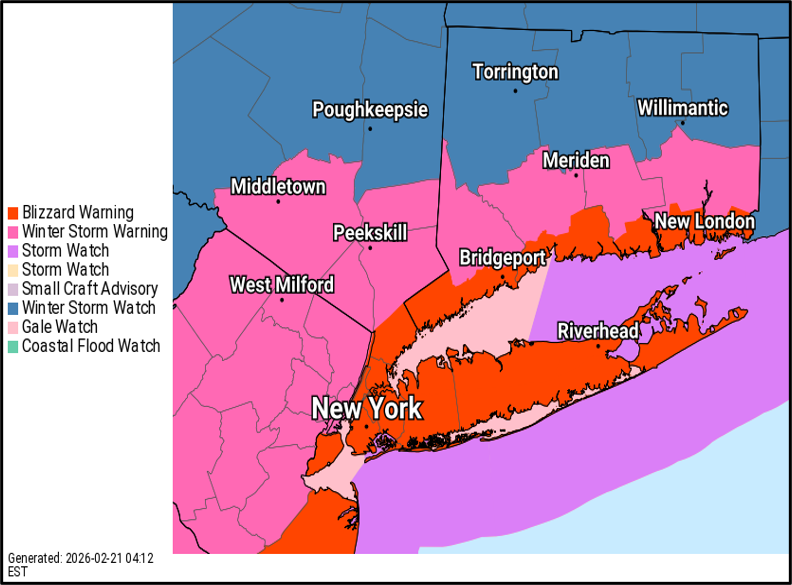
Blizzard warnings already populating across coastal CT and all of Long Island including NYC. Winter storm warnings across the rest of the 4 southern counties of CT - these will expand too. Winter storm watches everywhere else. Warnings begin 6am Sunday and run through 6pm Monday.
Full update shortly.
❄️Our new snowfall forecast brings 1-1.5 ft of snow area-wide, with the highest totals at the coast. Areas under a Blizzard Warning could see whiteout conditions with visibilities below a quarter mile in heavy blowing snow and winds gusting up to 55 mph.
⚠️ A strong nor'easter will bring heavy snowfall to our area Sunday into Monday. We have upgraded our Winter Storm Watches to Blizzard Warnings along the coast and Winter Storm Warnings elsewhere.
Ushering in the wind and cold, a light snow moves through tonight into Saturday.
❄️ Total Snowfall: 0.5 to 2 inches, highest amounts eastern Long Island and southeast CT
🕘 This Evening - Saturday Morning
⚠️ Roads may be slick even if they just look wet. Use extra caution.
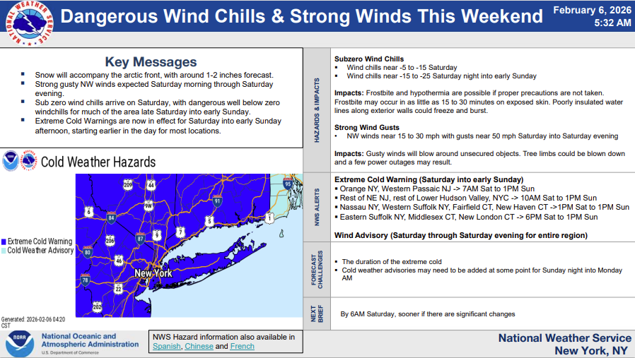
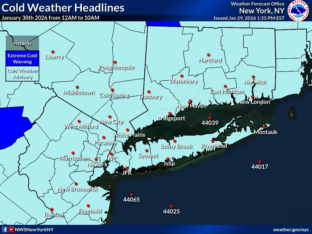
⚠ Extreme Cold Warning Sat to 1pm Sun
⚠ Wind Advisory Sat & Sat night
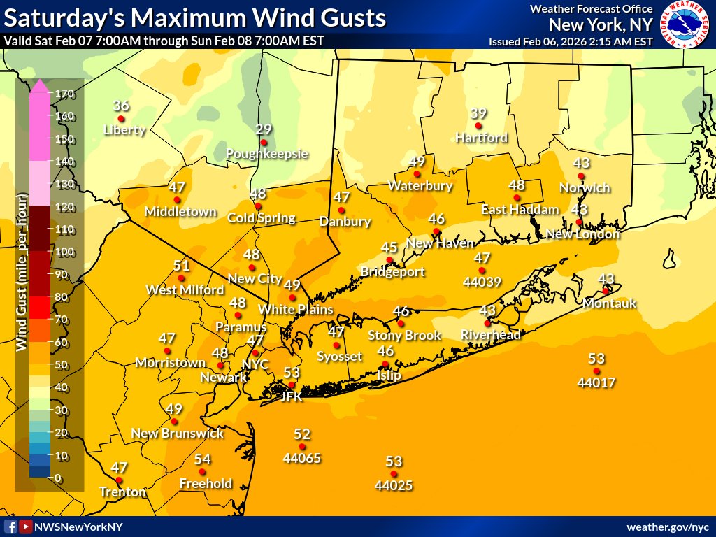
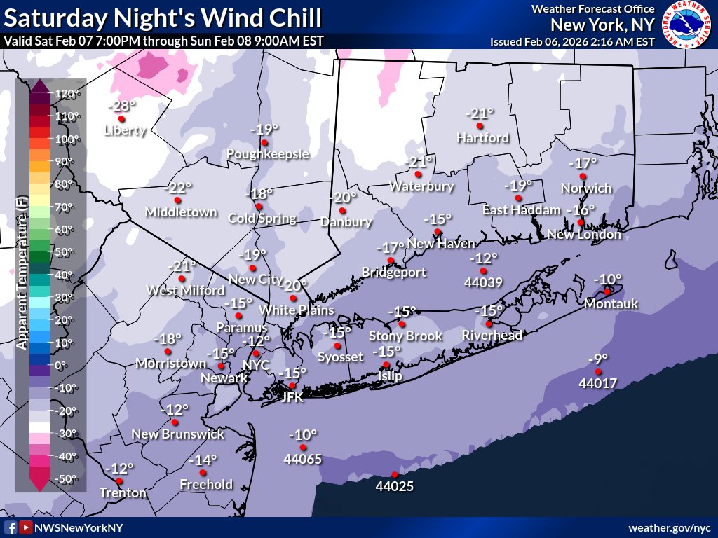
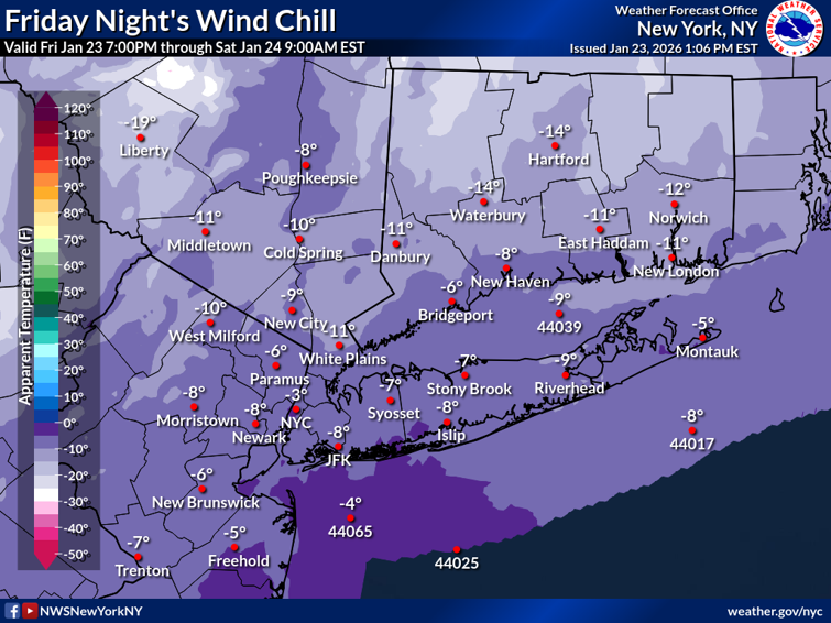
❄Arctic air this weekend with wind chills falling below 0 through Sat, then to -15 to -20 near coast and -20 to -25 inland Sat night/Sun morning.
💨NW winds 15-30 mph with gusts to 50 mph Sat into Sat eve.
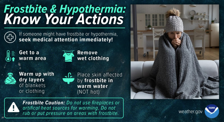
The relentless frigid temperatures continue tonight with the entire area under Cold Weather Advisories from midnight to 10AM tomorrow. The "feels-like" temperatures during this time will be anywhere from -5° to -15°! Avoid skin exposure if going outside.
8PM STORM UPDATE | BIGGEST NYC SNOWFALL IN 5 YEARS — SNOW vs. SLEET BATTLE CONTINUES
Take a look at the battle unfolding just north of NYC. If this sleet line fails to make meaningful northward progress, we could squeeze out another 2–5″ across the Lower Hudson Valley, northern New Jersey, and much of Connecticut.
That’s the BOOM potential in this forecast — and it’s starting to verify.
PIX11 Snow Max FORECAST from Friday was: 18″
We’re on pace to over achieve it…
What’s driving this? An extremely tight thermal gradient at 850mb as the coastal low continues to strengthen. That sharp boundary is the difference between heavy snow and sleet — and right now, snow is holding its ground in key areas.
Apologies for fewer updates — I’ve been on TV nonstop since 2PM.
Back again tonight at 10PM on @PIX11News ❄️📺
1PM STORM UPDATE| HIGH SNOW RATIOS HAVE BEEN ACHIEVED.. GOING FORECAST REMAINS UNCHANGED WITH HIGHER END TOTALS
Will the arrival of early morning snow we tapped into very high snow ratios (unconfirmed 30:1+) The going forecast remains unchanged with slow advancement of the sleet line before strong FGEN banding starts to form this afternoon.
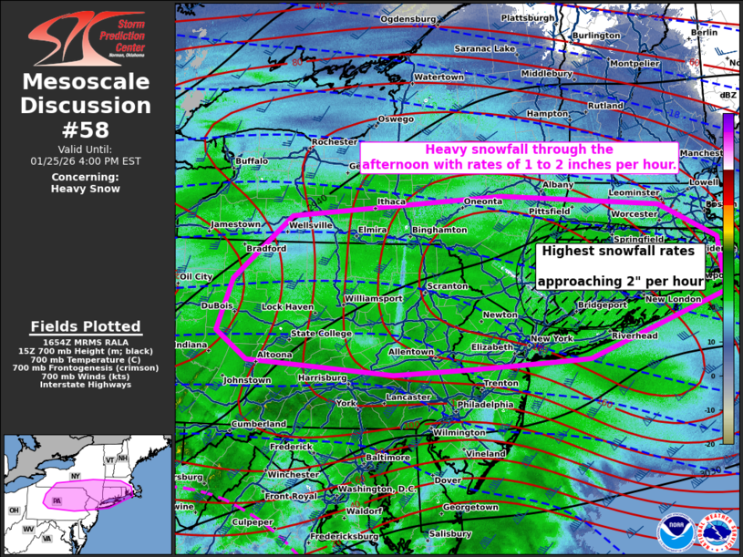
SPC has outlined (and I agree) for this area to achieve intense snowfall later this afternoon. It is not impossible to get over 2" snow rates per hour as the sleet line lifts north tightening the thermal gradient.
Widespread heavy accumulating snow and sleet is expected Sunday morning into Monday. The storm has trended a little more north, which means a period of heavy snowfall will be followed by more sleet accumulation at the coast. Even this carries with it its own dangers.
Heavy snow is expected Sunday morning into Sunday evening, transitioning to heavy wintry mix for the city/coast Sunday afternoon/evening. Lingering significant travel likely impacts late Sunday Night into Monday. Full Briefing HERE: https://t.co/610UeEEOhv
A major winter storm is on track to impact the region Sunday morning into Monday. The Winter Storm Watch has been upgraded to a Warning. In addition, a prolonged period of frigid air will affect the region tonight through next week.
Latest briefing here: https://t.co/610UeEEOhv
[Key Messages]: A significant winter storm is likely late Saturday night into Monday. Snow may begin late Saturday night with the heaviest snow likely falling Sunday into a portion of Sunday evening. Considerable disruption to transportation and daily life is possible.
We're continuing to monitor the increasing potential for a winter storm Sunday into Monday. Specific details on exact timing and amounts will become clearer over the next few days.


![NWSNewYorkNY's tweet photo. [Key Messages]: A significant winter storm is likely late Saturday night into Monday. Snow may begin late Saturday night with the heaviest snow likely falling Sunday into a portion of Sunday evening. Considerable disruption to transportation and daily life is possible. https://t.co/dwRfGcvbxv](https://pbs.twimg.com/media/G_QhU1pWEAAbrck.jpg)


