The official Twitter of Texas Woman's University Emergency Management.
Providing emergency info and preparedness tips to the TWU community.
Pioneer Proud!
Scattered storms are possible from this morning into the afternoon mainly in North Texas, some of which may produce frequent lightning and strong downburst wind gusts. Areas unaffected by thunderstorms will have another hot and humid afternoon with heat index values up to 105.
Heat and humidity will combine for heat index values up to 105 degrees on Saturday. Anyone spending time outdoors should take precautions to avoid heat-related illness by staying hydrated, taking frequent breaks, and limiting strenuous activity during the hottest part of the day.
Showers and storms arrive along a cold front today, a few of which may become severe with large hail and damaging winds. Storms should exit late evening with a mostly quiet night to follow. Stay weather aware! #dfwwx#ctxwx#txwx
Widespread showers & storms are expected with a cold front on Sunday (Mother's Day), with a threat for a few strong to severe storms as well as locally heavy rain. Keep an eye on the weather (especially if you have outdoor plans) & check back for more details! 🌷⛈️ #dfwwx#ctxwx
Saturday will start a period of above normal temperatures for the region with highs climbing into the mid and upper 80s. Isolated thunderstorms will also be possible in Central Texas. We are not expecting these storms to be severe at this time.
Mostly cloudy and cooler weather is expected today with a few passing showers and isolated storms. Some of the elevated storms may produce some hail, but the overall threat for severe weather is lower for our area.
Also, here's the forecast as we end the work week. #dfwwx#ctxwx
Isolated storms are possible this evening along a cold front across portions of North and Central TX. The thick cirrus is casting some uncertainty on storm development, but should any form they will have the risk for large hail and damaging winds.
Rain chances continue into Friday, with the best chances being across Central Texas. Severe weather is unlikely, but a few strong storms may occur. Temperatures will be well below normal, with highs in the 50s to lower 60s. #texomawx#ctxwx#dfwwx
Scattered storms will continue on and off the rest of today, with greatest coverage near and south of I-20. Some storms mainly in Central and East Texas could become severe with large hail up to 2"+ the main threat. Isolated coverage is expected further north. #dfwwx#ctxwx
Aviso de Tormenta Severa continúa Arlington TX, Denton TX, Flower Mound TX hasta las 6:00 PM CDT. ¡Esta tormenta contiene ráfagas de vientos de 70 MPH y granizo del tamañode una pelota de golf
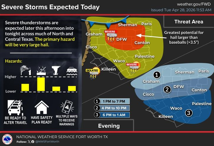
Severe thunderstorms are expected today across much of North and Central Texas. Large hail greater than baseballs will be the primary threat. Be weather aware and have multiple ways to receive warnings! Stay safe today y'all!
Heads up, Denton County!
A new Tornado Watch has been issued, valid until 5:00AM tomorrow morning.
Please ensure you have multiple ways to receive alerts and remain weather aware through the overnight hours.
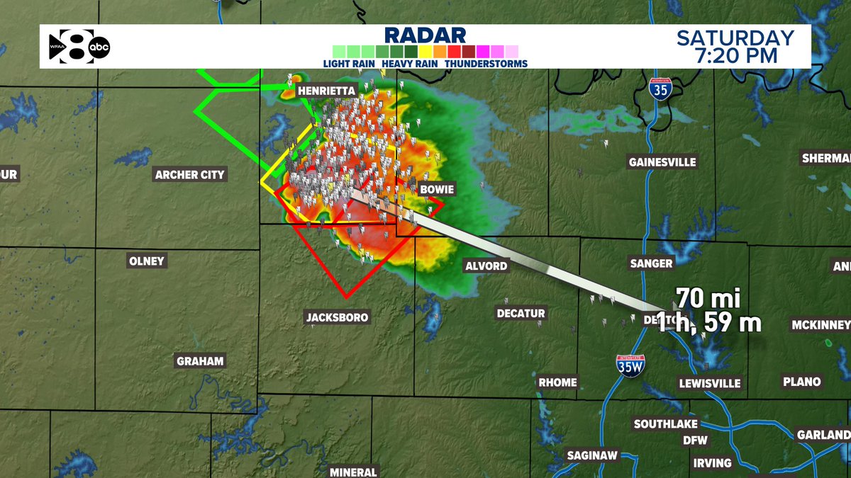
Radar image taken at 10:49PM
A Tornado Watch is now in effect for much of North Texas until 11 PM tonight. Any storm would have the potential to produce hail greater than softball size, a couple strong tornadoes, and damaging winds. Make sure to have multiple ways to receive warnings! #txwx#dfwwx
An isolated severe threat will continue Saturday and Sunday, with storm chances around 10 to 30%. Highs will be in the upper 80s/low 90s. Keep a close eye on the forecast for this weekend! #dfwwx#ctxwx#txwx