The BC Public Lands Map is funded by @cmhc_ca through the National Housing Strategy's Demonstrations Initiative.
It's been shaped by our advisory committee of housing partners across BC. (1/2)
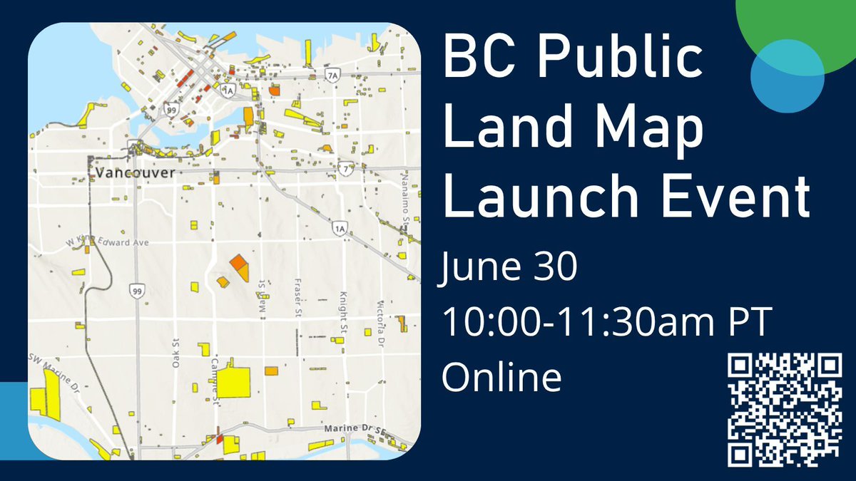
The BCPLM integrates DASH readiness metrics: slope, hazard risk, zoning, regulatory complexity. Visible upfront. Scoping work happens on sites with a real chance.
June 30: https://t.co/VUpEvlhWuj #housing (2/2)
Most BC non-profit housing providers have had this experience: months of scoping a site, only to find it's not viable. Wrong zoning; slope; environmental constraints; a regulatory layer nobody flagged. (1/2)
Hey Vancouver housing sector!
See you tonight at @UBCRobsonSquare for Thinking Beyond the Market—a free screening and panel with film director @bmdoucet, @hogans_alley's Djaka Blais, @ubcHART's Dr. Craig Jones & @andreareimer.
Register at: https://t.co/PtfhOLFhtM
Why doesn't BC already have a map of its public land?
It does, in pieces. Scattered across systems that don't talk to each other. The BCPLM stitches them together.
June 30: https://t.co/VUpEvlhWuj
#bcpoli#housing
Happening Monday!
Join us at @UBC Robson Square for a free screening of Thinking Beyond the Market & panel with film director @bmdoucet, @hogans_alley's Djaka Blais, @ubcHART's Dr. Craig Jones & @andreareimer.
🗓️More details and registration at: https://t.co/hqN8k0TbQy
Mandate a public land inventory. Centralize land coordination. Bind affordability into land dispositions. Strengthen intergovernmental partnerships. Read it: https://t.co/qDwluBan1J #bcpoli#housing (2/2)
New report: a comprehensive review of the laws, policies and systems governing public land use in BC, plus 6 low- or no-cost actions that could unlock major non-profit and affordable housing on government-owned land. (1/2)
Ontario has the largest social housing waitlist in the country. The province cut Toronto's shelter funding by 80% since 2024. Encampments are a housing problem, not a legal one. https://t.co/ffdEwO3TAJ #onpoli#housing
Ontario court rules clearing a Kitchener encampment would violate residents' Charter rights. Premier Ford calls it "the most ridiculous ruling I've ever seen."
Underfunding and restricting affordable and supportive housing for decades is ridiculous.
@cityoftoronto Mapping other provinces and territories is possible, it just requires data infrastructure and transparency to make it happen.
https://t.co/s2xYn35qYp
Pleased to see the @CityofToronto displaying open data on public land within Transit-Oriented Development areas. Now imagine expanding that map to include all public land (not just city-owned within TOA), everywhere in Ontario.
https://t.co/WuCaseLqfn
A vacant parcel isn't automatically a good site for housing. Walkability, transit, schools, clinics: these are what determine whether residents can actually live there well. (1/2)
Public land data in BC sits in dozens of fragmented systems. The BC Public Lands Map fixes that.
Launching Tuesday June 30, 10am PT / 1pm ET: https://t.co/VUpEvlhWuj
#bcpoli#housing (2/2)
The cost of land can account for up to 60% of a new building's total price.
Using public land for housing pulls that cost out of the equation. But governments can't act on land they can't see. (1/2)
Federal. Provincial. Regional. Municipal. School boards. Health authorities. TransLink.
BC's public land is owned by dozens of entities. The BCPLM puts them on one map.
June 30: https://t.co/VUpEvlhWuj
#housing
Save the date: June 30, 10am PT / 1pm ET.
We're launching the BC Public Lands Map: a map of every piece of publicly-owned land in BC, assessed for housing potential.
Register: https://t.co/VUpEvlhWuj
#bcpoli#housing
HART has been featured in @UBCMagazine's "Future of Housing" edition, highlighting the innovative research happening @UBC, including our upcoming Public Lands Map, modular construction, and sustainability.
Read more: https://t.co/13ykEbf2bn
#housing#research