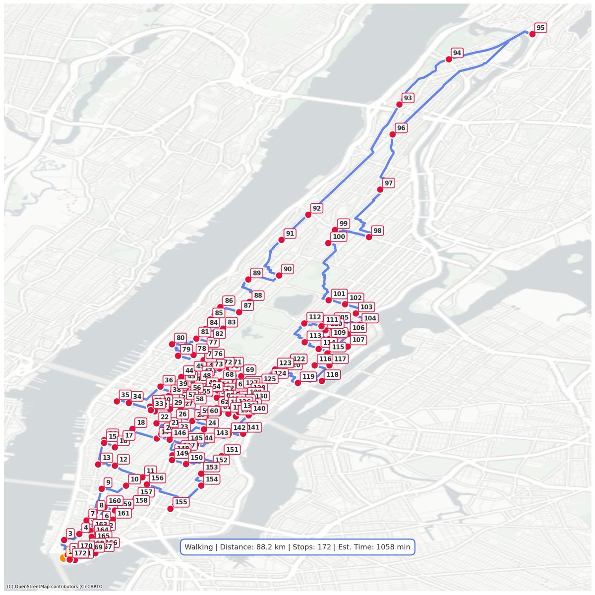
Visualizing the hidden arteries of cities through their favorite brands. 🗺️📍
We locate every shop of a specific brand in a city and calculate the optimal walking loop connecting them all. It’s data visualization meets urban culture.
From the "survival routes" of Starbucks in Manhattan to the coastal flip-flop trail of Havaianas in Rio... (See images below 👇)
Which Brand + City pair should we map next? Reply below! 🗣️
#UrbanLoop #OpenStreetMap
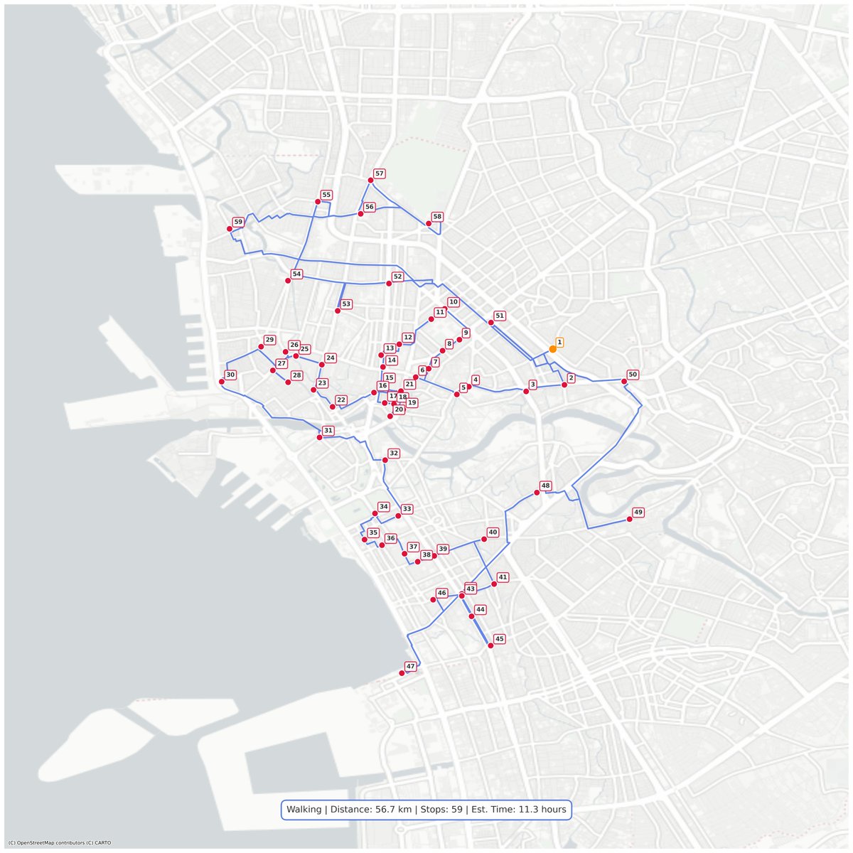
📍Optimized Route: Jollibee in Manila, Philippines 🇵🇭
In the Philippines, the "Red Bee" is king. It’s one of the few places on Earth where a local brand consistently outsells global giants.
🚶♂️ Distance: 56.7 km
🛑 Stops: 59 Locations
⏱️ Est. Time: 11.3 Hours
#Manila 🇵🇭#Jollibee #UrbanLoop #OpenStreetMap
📍 Optimized Route: InPost in Warsaw, Poland 🇵🇱
In Poland, the streets don't just belong to people; they belong to the machines.
With over 1,400 locations, this isn't a map anymore; it's a microchip. The ultimate logistical matrix where the algorithm takes over.
🚶♂️ Distance: 889.7 km
🛑 Stops: 1,421 Locations
⏱️ Est. Time: ~177.9 Hours
#Warsaw 🇵🇱#InPost #UrbanLoop #OpenStreetMap
Visualizing the hidden arteries of cities through their favorite brands. 🗺️
We locate every shop of a specific brand in a city and calculate the optimal walking loop connecting them all. It’s where data visualization meets urban culture.
From the "survival routes" of Waffle House in Atlanta to the coastal flip-flop trail of Havaianas in Rio...
👀 See full maps in my pinned tweet.
Which Brand + City pair should we map next? Reply below! 🗣️
#UrbanLoop #OpenStreetMap
📍 Optimized Route: KFC in Johannesburg, South Africa 🇿🇦
In South Africa, KFC isn't just fried chicken; it's practically a national dish.
🚶♂️ Distance: 326.5 km
🛑 Stops: 72 Locations
⏱️ Est. Time: ~65.3 Hours
A finger-lickin' long trek. 👇
#Johannesburg 🇿🇦#KFC#UrbanLoop #OpenStreetMap
📍 Optimized Route: Leonidas in Brussels, Belgium 🇧🇪
In the capital of chocolate, sugar levels never drop.
🚶♂️ Distance: 25.4 km
🛑 Stops: 14 Locations
⏱️ Est. Time: ~5.1 Hours
The sweetest walk you'll ever take.
#Brussels 🇧🇪#Leonidas#UrbanLoop#OpenStreetMap
📍 Optimized Route: Waffle House, in Atlanta, USA 🇺🇸
According to FEMA, if Waffle House is open, everything is fine.
🚶♂️ Distance: 70.0 km
🛑 Stops: 11 Locations
⏱️ Est. Time: ~14.0 Hours
#Atlanta 🇺🇸#WaffleHouse#UrbanLoop#OpenStreetMap
📍 Optimized Route: Guinness in Dublin, Ireland 🇮🇪
Guinness isn't just a beer here; it's the lifeblood of the city.
🚶♂️ Distance: 10.2 km
🛑 Stops: 13 Locations
⏱️ Est. Time: ~2.0 Hours
Sláinte! 🍻
#Dublin 🇮🇪#Guinness#UrbanLoop#OpenStreetMap
📍 Optimized Route: Havaianas in Rio de Janeiro, Brazil 🇧🇷
In Rio de Janeiro, wearing flip-flops isn't a choice; it's a must.
🚶♂️ Distance: 102.7 km
🛑 Stops: 14 Locations
⏱️ Est. Time: ~20.5 Hours
Do not attempt this walk in sneakers.
#RioDeJaneiro 🇧🇷#Havaianas#UrbanLoop #OpenStreetMap
📍 Optimized Route: Shell in Ankara, Turkiye 🇹🇷
Ankara is a city built for cars, not pedestrians. This map proves it.
🚶♂️ Distance: 966.9 km
🛑 Stops: 57 Locations
⏱️ Est. Time: ~193.4 Hours
#Ankara 🇹🇷#Shell#UrbanLoop#OpenStreetMap
📍 Optimized Route: 5 to go in Bucharest, Romania🇷🇴
Need a coffee? You don't need to walk far.
🚶♂️ Distance: 194.7 km
🛑 Stops: 124 Locations
⏱️ Est. Time: ~38.9 Hours
#Bucharest 🇷🇴 #5togo#UrbanLoop#OpenStreetMap
📍 Optimized Route: Indomaret in Jakarta, Indonesia 🇮🇩
This is not a biological cell; it's a map of retail dominance.
🚶♂️ Distance: 595.0 km
🛑 Stops: 466 Locations
⏱️ Est. Time: 119.0 Hours
#Jakarta 🇮🇩#Indomaret#UrbanLoop#OpenStreetMap
📍 Optimized Route: Ferrari in Dubai, United Arab Emirates 🇦🇪
It’s the slowest way to experience the highest speed.
🚶♂️ Distance: 39.3 km
🛑 Stops: 4 Locations
⏱️ Est. Time: ~8 Hours
#Dubai 🇦🇪#Ferrari#UrbanLoop#OpenStreetMap
📍 Optimized Route: OXXO in Mexico City, Mexico 🇲🇽
Mapping the absurd coverage of OXXO convenience stores across CDMX.
🚶♂️ Distance: 632.5 km
🛑 Stops: 650 Locations
⏱️ Est. Time: ~126.5 Hours
#MexicoCity 🇲🇽#OXXO#UrbanLoop#OpenStreetMap
📍 Optimized Route: Kaldi's Coffee in Addis Ababa, Ethiopia 🇪🇹
The Original Caffeine Run. ☕️🏃🏾♂️
Walking 72km at 2,300m altitude? You are definitely going to need that espresso.
🚶♂️ Distance: 71.8 km
🛑 Stops: 16 Locations
⏱️ Est. Time: ~14.4 Hours
#AddisAbaba 🇪🇹#KaldisCoffee #UrbanLoop #OpenStreetMap
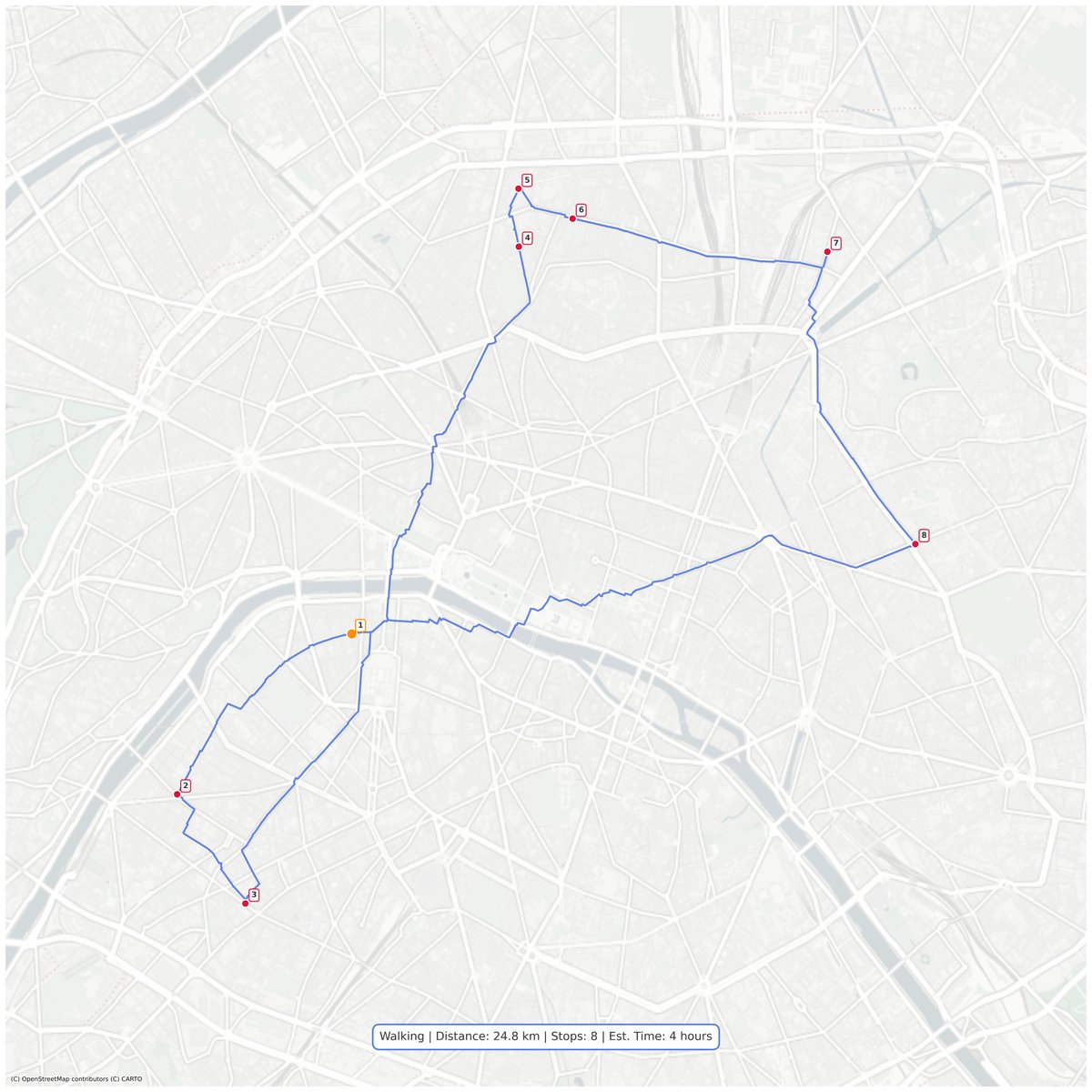
📍 Optimized Route: Boulangerie in Paris, France 🇫🇷
The Romance of Bread.🥖🥐
🚶♂️ Total Distance: 24.8 km
🛑 Stops: 8 Locations
⏱️ Est. Walking Time: ~4 Hours
#Paris 🇫🇷#Boulangerie#UrbanLoop#OpenStreetMap
📍 Optimized Route: Albert Heijn in Amsterdam, Netherlands 🇳🇱
The Blue Labyrinth. 🔵🧀
Navigating the famous canal belt to visit every "Appie" in the city. A route scientifically designed for maximum Stroopwafel intake.
🚶♂️ Total Distance: 153.1 km
🛑 Total Stops: 83 locations
⏱️ Est. Walking Time: ~30 Hours
Vergeet je Bonuskaart niet.
#Amsterdam 🇳🇱 #AlbertHeijn #UrbanLoop #OpenStreetMap