Most people know USLandGrid because of our land grid and parcel data. What many don't realize is that we've spent years doing custom GIS work for customers across the country.
We've mapped utility easements from old plats, legal descriptions, and scanned documents in a GIS.
One of the most overlooked layers in land mapping is lot data. Most people focus on sections, townships, surveys, abstracts, or parcels. But when you get into the real-world details of ownership, leasing, permitting, title, or asset management, lots become incredibly important.
The reality of land parcel data? It’s fragmented, inconsistent, and often outdated.
We’ve engineered around those problems.
What makes this different:
1. Nationwide standardized schema (no stitching required)
2. Frequent, predictable updates
3. Clean, analysis-ready geometries
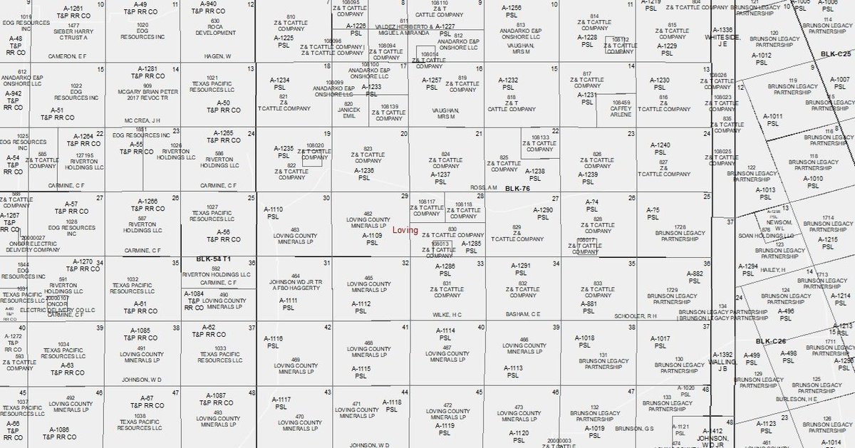
Texas Leagues & Labors - Now Statewide in Version 12 of the Texas Land Grid
With Version 12 of the USLandGrid Land Grid, we’ve taken a major step forward:
⚡ Statewide Leagues & Labors Coverage - Fully Enhanced
We’ve expanded and refined Leagues & Labors across Texas.
Bad Land Data Doesn’t Fail Loudly - It Fails Quietly
- Misaligned boundaries
- Incorrect ownership assumptions
- Time lost validating what should already be correct
That’s why we built Version 12 of the USLandGrid Texas Land Grid the way we did.
Most Land Grid Problems Don’t Show Up Until It’s Too Late
They show up when:
1. Your overlays don’t line up
2. Abstracts don’t reconcile
3. Acreage calculations don’t match expectations
That’s exactly what Version 12 of the USLandGrid Texas Land Grid was built to fix.
Texas Land Grid Version 12 is Live - Built for Data Integrity at Scale
We’ve just released Version 12 of the USLandGrid Texas Land Grid - our most refined and rigorously validated dataset to date.
👉 If you’re working in land, GIS, or energy, this is worth a look.
Still working with hard-copy maps?
We turn them into accurate, GIS-ready digital data.
If you’re sitting on stacks of paper maps that need to be scanned, georeferenced, and attributed, USLandGrid can help.
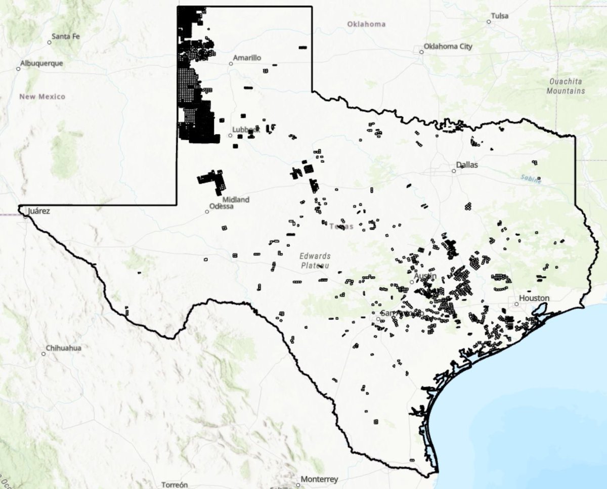
USLandGrid’s National Well Dataset delivers access to 4,000,000+ well records across the United States - built for energy teams, analysts, and GIS professionals who need accuracy, depth, and speed in one place.
About USLandGrid Parcel Data:
USLandGrid delivers the most comprehensive and current parcel datasets available nationwide, built from trusted local government and agency sources and standardized for consistency at scale.
160.2 million parcels covering 3,229 U.S. counties.
Texas land grid isn’t just built on abstracts. It’s built on leagues and labors - dating back to the original Spanish land grants.
Legal descriptions across Texas still reference leagues, labors, and original grants every day. Yet almost no modern datasets actually include them.
Mapping & Digitization Expertise
For more than 12 years, USLandGrid has partnered with municipalities, counties, parishes, and commercial organizations to transform complex legal descriptions and hard-copy maps into high-accuracy digital mapping products.
Roger Tomlinson, born on this day November 17, 1933, is widely recognized as the pioneer of GIS technology. His groundbreaking work in 1967 led to the creation of the first computerized GIS, setting the stage for modern spatial analysis and decision-making processes.
On November 3, 1793, Stephen F. Austin was born. Austin is best known for his plan to establish a colony in Spanish/Mexican Texas.
He is remembered for his leadership, vision, and contributions to the colonization and development of the state.
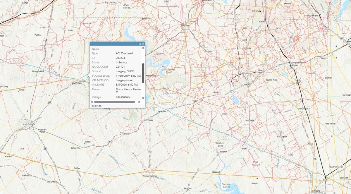
⚙️ Infrastructure Data That Brings Clarity to Every Connection
From roads and railways to powerlines, substations, bridges, and wind turbines, USLandGrid’s Infrastructure Data delivers a complete picture of how the nation is built - and how it connects.
🏗️ Building Footprints - Precision from the Ground Up
Every structure tells a story. With 124.6 million commercial and residential building footprints across the U.S., USLandGrid delivers unmatched location accuracy and spatial intelligence.
Nationwide Parcel Data - Standardized, Accurate, Ready to Use
USLandGrid delivers one of the most complete and reliable parcel datasets in the United States - covering over 160 million real estate parcels across 3,229 counties, representing more than 99% of the U.S. population.