Passionate Pluviophile from Chennai | Tracking Tamil Nadu's weather with a vibe | Cricket fanatic & movie buff | Not an expert,Follow IMD for official forecast
🌧️ Northeast Monsoon 2025 Outlook from Vihas and @TStormchaserrr
Guided by @vinod1705
🌊 ENSO
Currently, the ENSO is in a weak La Niña state with a value of −0.5°C, and it is expected to strengthen in the coming days, which is a great sign for the NEM over Tamil Nadu and South AP. 🌧️
🌊 IOD
The persisting negative IOD is also expected to intensify further in the upcoming days! ⚡
A stronger negative IOD will complement the La Niña base, favoring enhanced convection near the equatorial Indian Ocean and increased rainfall activity.
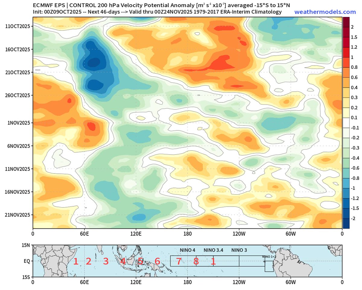
🌪️ Influence of IOD on MJO Progression
Under the influence of a strong negative IOD, the MJO (Madden–Julian Oscillation) is likely to spend more time in Phase 4 ⏳.
This setup will ensure that the Bay of Bengal receives frequent pulses from the South China Sea, keeping the Bay active at least until the first fortnight of November! 🌧️
🌈 MJO
The first MJO episode is expected around the last week of October, post-Diwali, with a strong amplitude over the Indian Ocean. 💥
The last week of October and the first fortnight of November are likely to be very favorable for entire Tamil Nadu, including KTCC (Chennai), as the MJO will be in its most supportive phase for rainfall. 🌧️
🌦️ The Climax of NEM
Once the MJO reaches Phase 4 or Phase 5, there is a high chance of it re-emerging in Phase 1 🔄.
However, the timing of this re-emergence remains uncertain.
If it happens by the last week of November or the first week of December, KTCC (Chennai) could experience excess rainfall. 🌧️
Even if this does not occur, KTCC is still expected to record normal to above-normal rainfall this monsoon. 🌤️
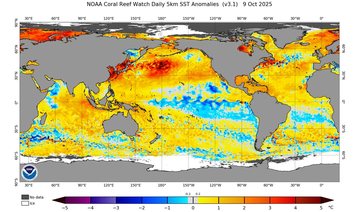
🌡️ SST (Sea Surface Temperature)
SST near TN Coast and Bay is warm which will act as a fuel source for convection and help rain bearing clouds near Coastals.
It also has ideal temperature which supports system intensification.
❄️ Western Disturbances
With a positive Arctic Oscillation and La Niña as the base state, the number of western disturbances is expected to be fewer this year ⚠️.
💨 QBO
The QBO (Quasi-Biennial Oscillation) is in its easterly phase this year.
During the easterly phase, the MJO tends to be more pronounced and exhibits a stronger amplitude, especially in December.
An easterly QBO also favors more west-northwest to northwest-moving disturbances, which will benefit Tamil Nadu and South Andhra Pradesh. 🌬️
📜 Analog Years
Based on past data, four analog years—1984, 1995, 2005, and 2020—had a weak La Niña emerging in the latter half of the year along with a negative IOD.
Let’s analyze their NEM performance:
1984 – 2 Cyclones (Sriharikota, Delta)
1995 – 2 Cyclones (North AP, Myanmar)
2005 – 2 Deep Depressions, 2 Cyclones (Baaz, Fanoos)
2020 – 2 Cyclones (Nivar, Burevi)
All these years witnessed an active Bay of Bengal with strong and frequent systems. 🌪️
🌤️ Conclusion
The Northeast Monsoon 2025 is expected to be normal to above normal for Tamil Nadu and South Andhra Pradesh, with a good number of disturbances forming in the Bay of Bengal.
At least two strong systems (Cyclones/Deep Depressions) are likely, similar to our analog years.
Coastal Tamil Nadu, especially from Tiruvallur district to the Delta coast, should remain vigilant as there are higher chances of intense rainfall episodes over short periods.
Onset is expected between October 16th and 20th, starting with light to moderate rains along the coast.
October 20th to mid-November is likely to be very active, with back-to-back systems forming in the Bay. With the MJO looping back, late November to December will also be very active, favoring South Tamil Nadu and the Delta region.
📍 Region-wise Rainfall Expectations
KTCC to Pondy - Normal to Above Normal
Pondy to Delta Coast- Excess
Interior Districts - Above Normal
Kongu Belt - Normal
South Tamil Nadu - Normal to Above Normal
South Andhra Pradesh - Excess
Note : This is an unofficial Forecast and Outlook. For official, please follow IMD
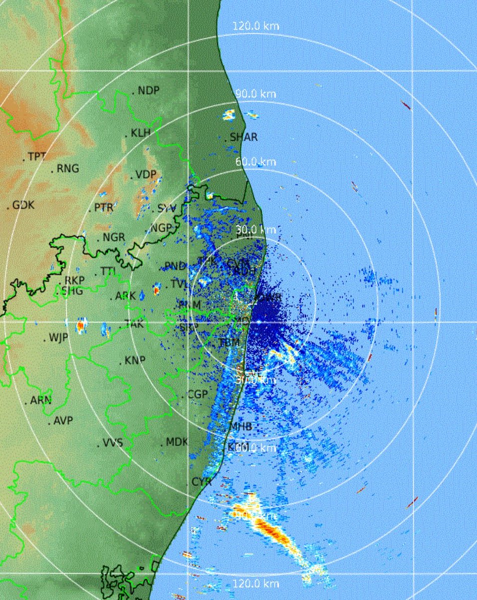
Intense storms sweeping #Chennai and Suburbs. Heavy rains happening in Ayapakkam Ambattur Anna nagar belt.Chennai city too will get this spell soon.
#ChennaiRains
Yet Another Rainy evening/night ahead for #Chennai and Suburbs. KTCC Villupuram Ranipet Pondy Cuddalore Vellore will get light to moderate rains. One or two places can get heavy rains. Another hot day for Chennai and hope rain cools down.
#ChennaiRains
Isolated places got light showers here and there,but more storms lined up west of Chitoor and Vellore belt. High chances for #Chennai and Surbubs to witness another spell of rains tonight. Let's keep an eye on radar.
#ChennaiRains
Rainy evening ahead for #Chennai and suburbs. After a hot day, thunderstorms have started forming over the interior and will move towards the coast. The sea breeze will act as a trigger and may make the storms more intense.
#ChennaiRains
We live for moments like this ❤️.
A small glimpse of the most brutal Thunderstorm of the year lashing Ayapakkam , Western Suburbs of Chennai .
@praddy06@ChennaiRains@jhrishi2@MasRainman
Nasty spell happening in Nw of #Chennai. Ambattur and Ayapakkam getting heavy rains now. Upcoming hours Ranipet Kanchi belt will turn active.
#ChennaiRains
Widespread Rains possible for North TN this evening - night. With favourable wind convergence KTCC including #Chennai and Suburbs,Vellore,Ranipet, Villupuram,Pondy will get moderate to heavy rains. Finally good respite from continuous 40c.
#ChennaiRains
Another hot day ahead for Chennai and suburbs. Like yesterday most places in the city would see temperature peak around 40°C while suburbs may see around 41°C. We will continue to remain spectators as thunderstorms are likely to form once again around 50 - 100 to our west and move further away towards interior areas of Peninsular India.
Ripper heat in Chennai. Meenambakkam has recorded 41C at 2 p.m.!! Many private weather stations in Chennai have breached 40C easily. Neelangarai has recorded a peak temp of 41.9C today…models were spot on in bringing severe heatwave conditions.
#Chennai#Heat#Summer#Tamilnadu
What a cool and rainy morning at #Chennai. With a circulation near SL , today Coastals and interior dt will get light to moderate showers. Delta dt and South TN Coast might get Heavy rains at one or two places. Enjoy a cool day.
Widespread moderate to heavy rains possible over south #Tn and #Kerala especially places closer to ghats coastal places between #Ramanathapuram to #Chennai will see moderate rains in night/early morning hours #Chennairains