Don't let hidden weather damage cause more expensive issues down the line. Check your address and sign up for FREE weather damage notifications today! https://t.co/adwuu6BaUw
Just in: NOAA index tracks how greenhouse gas pollution amplified global warming in 2022.
Greenhouse gas pollution from human activity trapped 49% more heat in atmosphere during 2022 than same gases did in 1990.
https://t.co/Quxefa9Eed
@NOAAResearch#AGGI#ClimateChange
Happy #WorldTurtleDay!
#DidYouKnow@NOAA helps track marine life with #Argos?
By mapping the migration routes of tagged #loggerhead#SeaTurtles, we can see that they base their course on a specific chlorophyll and temperature gradient.
Learn about Argos: https://t.co/n7NjFojHkU
Mount #Popocatepetl in Mexico continues to erupt this morning. Below is the #satellite composite RGB channel for monitoring Sulfur Dioxide (SO2), which shows up in orange or yellow. Since the plume is mostly dark blue, it indicates there is very little or no SO2 content.
When the sun was overhead earlier today, Japan's #Himawari9 🛰 captured this imagery of what is now Super Typhoon #Mawar churning over the Pacific.
A Typhoon Warning remains in effect for Guam and Rota.
Latest:
https://t.co/WwcxbSz1cp
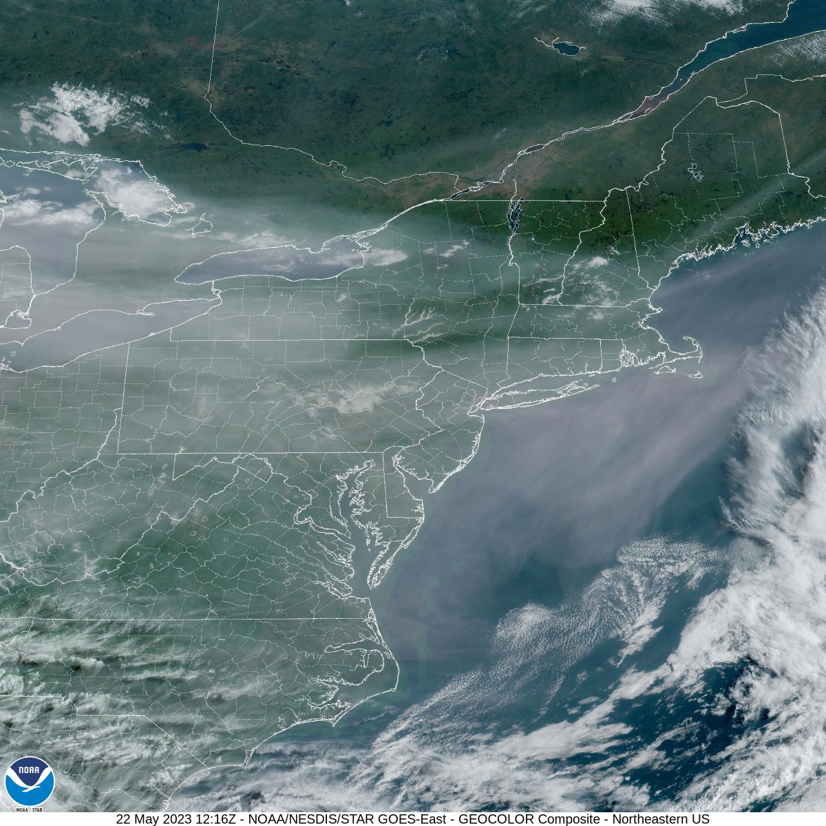
This #GOESEast CONUS view reveals how Canadian wildfire #smoke has shrouded so much of the U.S. today. Extensive - but nothing compared to western Canada where several fires still rage out of control - the good news is that rain showers are recently aiding firefighters.
Sunrise on Category 3 (and still intensifying) Typhoon #Mawar southeast of #Guam, seen using 2.5-minute Target Sector @JMA_kishou#Himawari9 Visible and Infrared images: https://t.co/Zgq7xgoBOL
Typhoon Mawar continues to organize and strengthen across the Western Pacific this evening, as seen via Himawari satellite imagery.
Latest JTWC warning graphic: https://t.co/TnQklqsyzv
Latest JTWC warning text: https://t.co/sqNu814s6y
#OTD in 2011, a devastating #EF5-rated #tornado struck #Joplin Missouri - GOES and MODIS imagery of the supercell can be found on the CIMSS Satellite Blog: https://t.co/oJo0tIkFTm
Typhoon #Mawar reached Category 3 intensity at 1800 UTC today -- 2.5-minute Target Sector @JMA_kishou#Himawari9 Infrared images showed that the eye was beginning to clear out around that time: https://t.co/G5J2FU8HeW
Mount #Popocatepetl about 70 km or 45 miles southeast of Mexico City continues to erupt, emitting large amount of ash. The highest #ash concentration (bright pink) is just east of the crater. A lower #concentration ash plume (light pink) is spreading across the Bay of Campeche.
In Utqiagvik, the northernmost community in Alaska (and by extension the United States) the sun will stay above the horizon until August. Despite the daylight, as seen in this True Color, snow remains over much of the North Slope and there is fast ice east of Point Barrow. #akwx
Over the next couple of days, you may notice a hazy/reddish look to the sky, especially around sunrise and sunset. This is due to widespread smoke continuing to spill south into the U.S. from wildfires in Canada. As of this evening, the smoke has reached as far south as NC. #ncwx
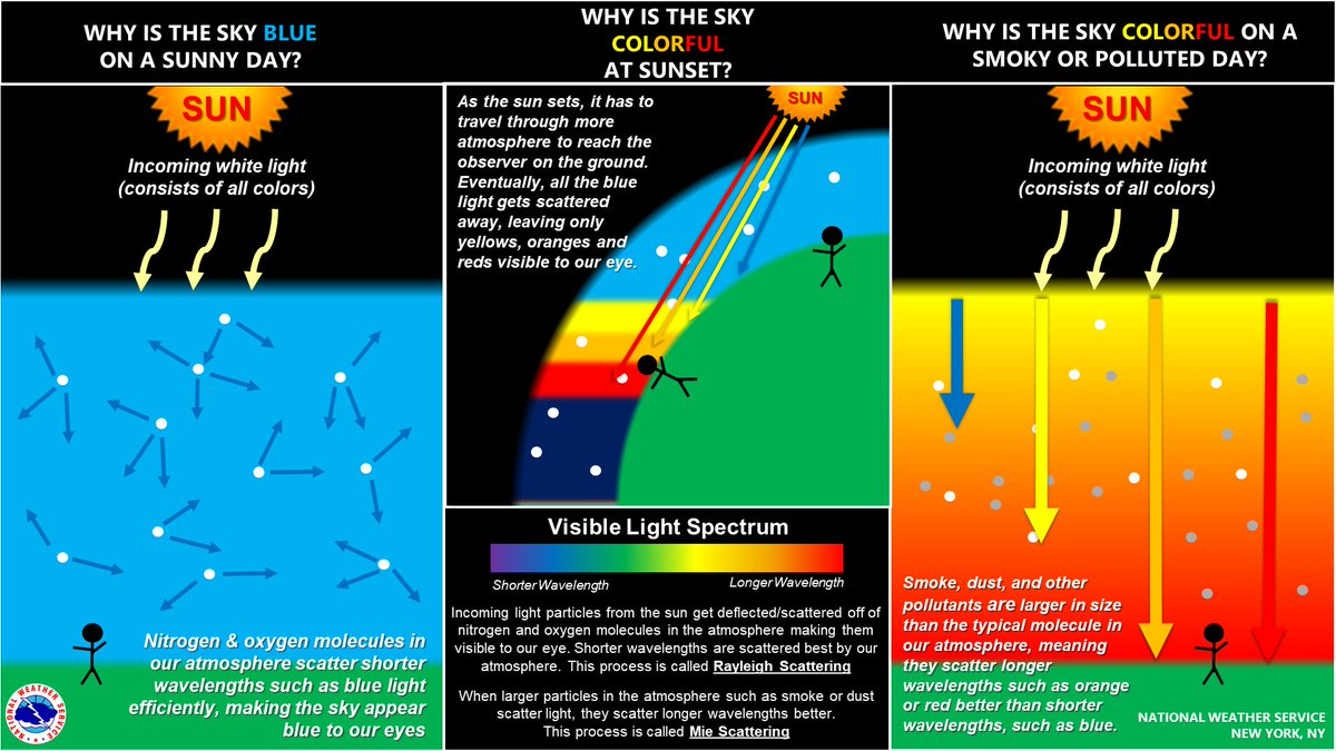
The smoke is really making its presence known on the GOES-16 satellite imagery from Canadian wildfires. It created a vivid sunset last night and sunrise this morning. The graphic attached shows you why the sky changes color on smoky days. #NYwx#CTwx#NJwx
As #TyphoonMawar tracks toward Guam, @NOAA's #NOAA20 satellite is carefully monitoring the intensifying storm and providing data for its forecast. This imagery of #Mawar churning over the Pacific was collected yesterday.
Latest:
https://t.co/fHDiQ4heeq
2.5-minute rapid scan @JMA_kishou#Himawari9 Infrared images showing #Mawar as it intensified to a Category 1 Typhoon southeast of #Guam -- cloud-top infrared brightness temperatures continued to be quite cold, generally in the -90 to -95 C range: https://t.co/Vsa123EkPW
1-minute Mesoscale Sector @NOAASatellites#GOES18/#GOESwest Fire Temperature RGB & Infrared mages showed a cluster of 3 #wildfires in British Columbia - 2 fires have produced #pyrocumulonimbus clouds within the past hour: https://t.co/NIbLP1gINR
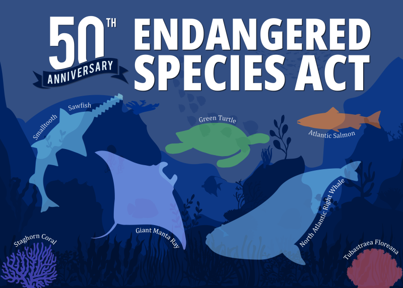
Happy #EndangeredSpeciesDay! Celebrate the 50th anniversary of the Endangered Species Act by learning more about @NOAA's work to conserve endangered species and their habitats 🐳🪸🦭: https://t.co/If9LCDUG62
#ESA50
This #FullDiskFriday, take a look at our planet from a different perspective!
Today's view of Antarctica was captured via @NOAA's #JPSS satellites, which orbit the Earth 14 times a day, collecting image swaths that help create a complete picture of the North and South Poles.