#ReadyWichitaFalls | Know the difference between a Watch vs. a Warning. We hope you TACO-about it at work and home today.
👀 Tornado Watch = Be aware.
🌪 Tornado Warning+ Take Action!
Visit, https://t.co/Ko8Ggp77RM
8:00 - A new tornado watch is in effect until 3:00 am. If you are west of this - including Enid, Woodward, Altus. Weatherford - then the severe threat has diminished for you.
If you are in this new watch, then severe weather is not over yet!
The safest place in a home to take shelter is in the basement or saferoom. If you don’t have a basement or saferoom, go to an inside room, without windows, on the lowest floor. This could be a center hallway, bathroom, or closet. Do NOT stay in a mobile home or vehicle. #TxWx
#Watch | The National Weather Service has extended the Severe Thunderstorm Watch until 2:00 am. We are seeing storms impacting our area now. Please stay #WeatherAware!
Alert Info, https://t.co/nNAQBfRMKC
#Watch | The National Weather Service has issued a Severe Thunderstorm Watch for the City of Wichita Falls, Texas until 11:00 pm. Stay #WeatherAware!
Alert Info, https://t.co/HN7uq9pSh2
#Watch | The National Weather Service has issued a Flood Watch for the City of Wichita Falls until Sunday Afternoon. 2 to 4 inches of rain is expected.
#TurnAroundDontDrown
Alert Info, https://t.co/bLnOQn3rQc
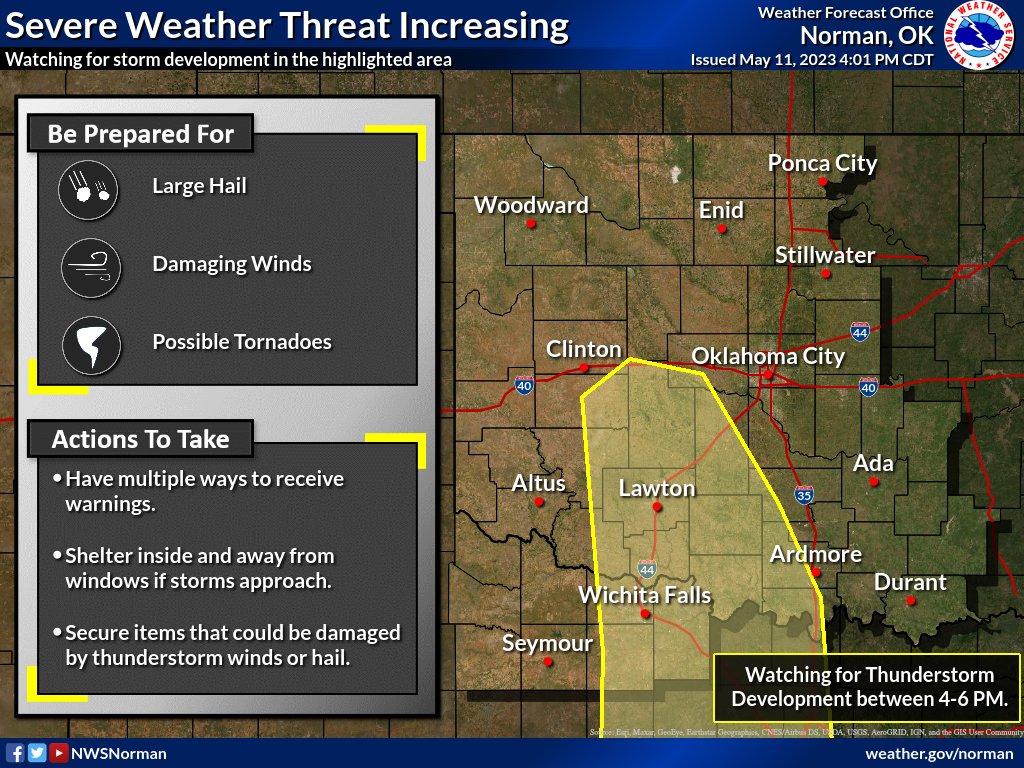
We continue to monitor hour-by-hour changes for where severe weather is likely to develop. Latest models, radar, and high-resolution models suggest storms will develop within the highlighted area by 6 pm. #txwx#okwx
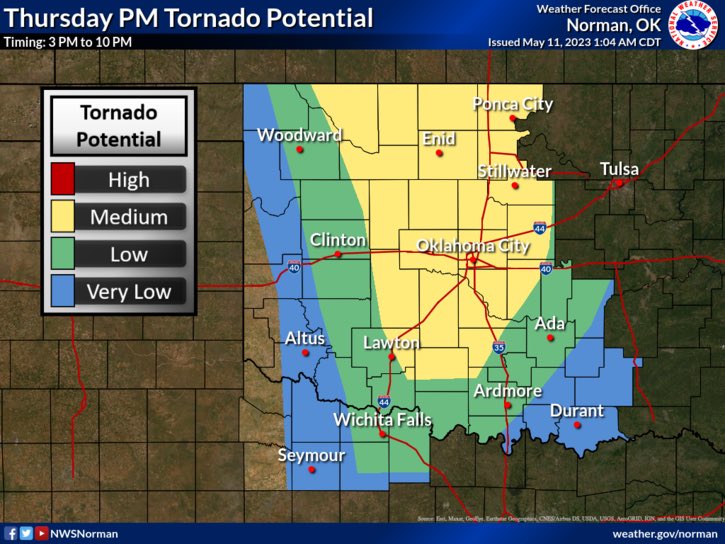
Satellite and model guidance continues to indicate the best chance of severe thunderstorm develop will occur across parts of western north TX and southern Oklahoma over the next 1 to 2 hours. Be ready to seek shelter if warnings are issued. #okwx#texomawx
#Watch | The National Weather Service has issued a Tornado Watch for the City of Wichita Falls, Texas, until 11:00 pm. Please stay #WeatherAware and follow for updates.
Alert Info, https://t.co/umH0OoDXbv
#ReadyWichitaFalls | Storms are possible this afternoon and evening! Have multiple ways of getting emergency alerts.
Learn more about alerts at, https://t.co/FqKWlpQ82H
#WeatherUpdate | Get ready for a long weekend of hazardous weather! We start today with a slight risk of strong to severe thunderstorms that are capable of producing all hazards. Please be #WeatherAware and keep updated with local forecasts.
#TXWX#ReadyWichitaFalls
#Watch | The National Weather Service has issued a Severe Thunderstorm Watch for the City of Wichita Falls, Texas until 9:00pm. Please stay #WeatherAware!
Alert info, https://t.co/YBOVxhUI32
Today: Expect another round of severe storms late this afternoon and into the evening.
Thunderstorms will be capable of producing baseball-size hail and damaging wind gusts up to 80 mph, primarily within the Slight Risk area (see below, area in yellow).
#okwx#texomawx
#Watch | The National Weather Service has issued a Severe Thunderstorm Watch for the City of Wichita Falls, Texas until 11:00 PM.
Alert Info, https://t.co/g8o9clAvkx
Severe storms are expected to fire ahead of a dryline over western north Texas & south-central OK (4-6 PM)...
Very strong instability will result in very large hail (baseballs), & high cloud bases (deep sub-cloud dry air) will result in wind gusts up to 80 mph.
#okwx#texomawx