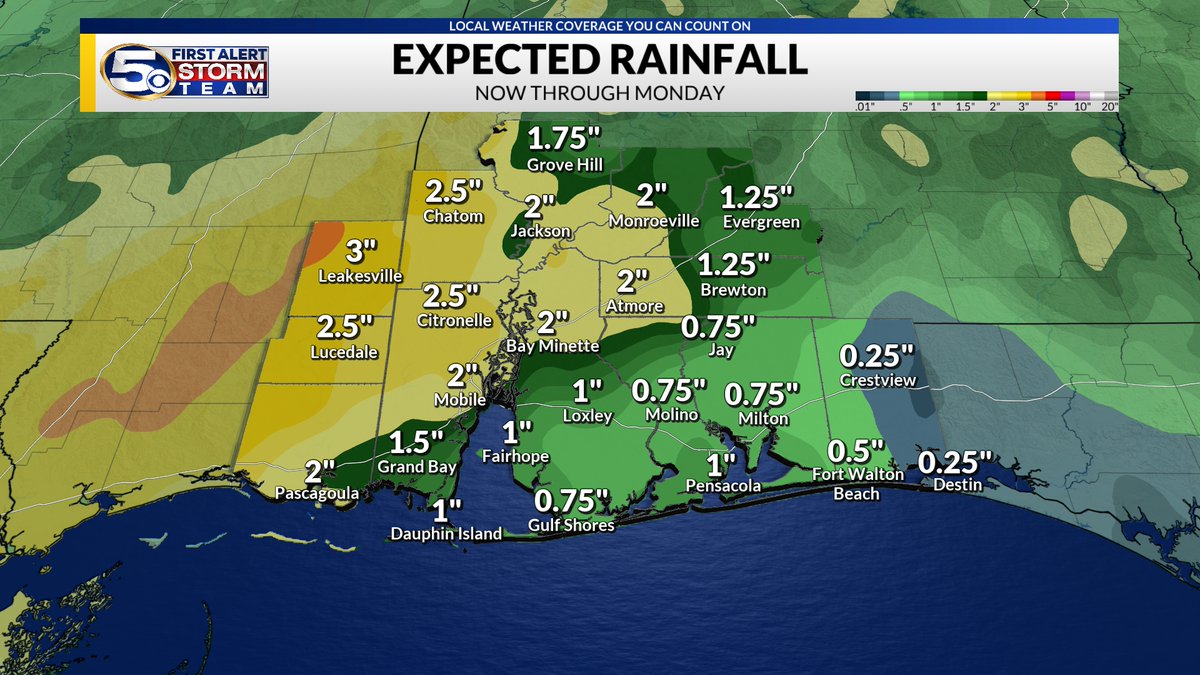
Scattered showers and thunder storms will move across the area for the coming days. Some of the Showers could have some heavy rainfall that could bring some flooding. 1-4 inches are possible with localized spots cold see 5+ inches.
Tropics Update🟡 | The area of development taking a different shape. Remaining a low chance of development as it heads towards Mexico but could scoot back in the NW Gulf next Tuesday and Wednesday. Still a lot of wind shear to keep it from development but will be a rain maker.
We are tracking Storms to develop later this Sunday. Heavy rainfall is possible in some of the storms that could lead to localized flooding. Greater rain chances look to stay around and north of I-65.
Radar Update 2:48 PM | Scattered showers and a few thunderstorms around. heavy downpours moving out of Baldwin county into Escambia county FL. More heavy downpours back west in south Mississippi causing flash flooding starting to move towards the news 5 area.
#alwx#mswx#flwx
Have an indoor backup plan ready to go for this weekend. Watching out for scattered showers and thunderstorms moving up from the coast Saturday and Sunday. Some places will see more rain than others this weekend. There is a low risk of flash flooding especially west of I-65.
Hot and humid today! Make sure to take breaks and stay hydrated while spending time outside. There is still a chance to see some showers and storms this afternoon.
We are watching for a wet memorial day with more showers and thunderstorm chances. Flash flooding is also a concern the next couple of days especially more in the inland counties.
Plenty of more showers and thunderstorms are expected over the next couple days. Be on the look out on Sunday and Monday in lower Alabama and Mississippi as with higher rain amounts, some localized spots could see more rain than others.