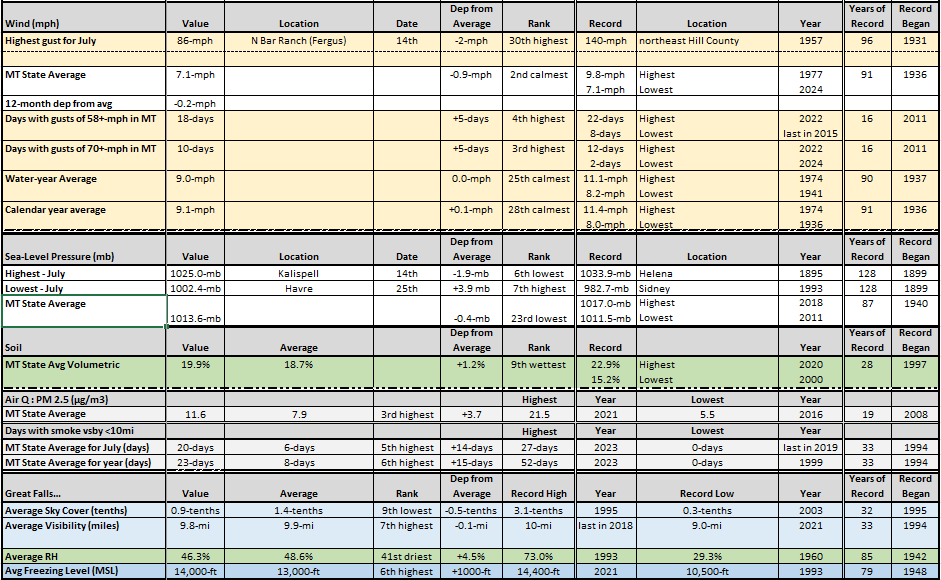
For July in MT, wind tstm wind gusts of +70-mph occurred on 10-days, the 3rd highest of record. There were 20-days with visibility less than 10 miles from smoke at some spot in MT, the 5th highest of record. Last year there were 22-days. #mtwx
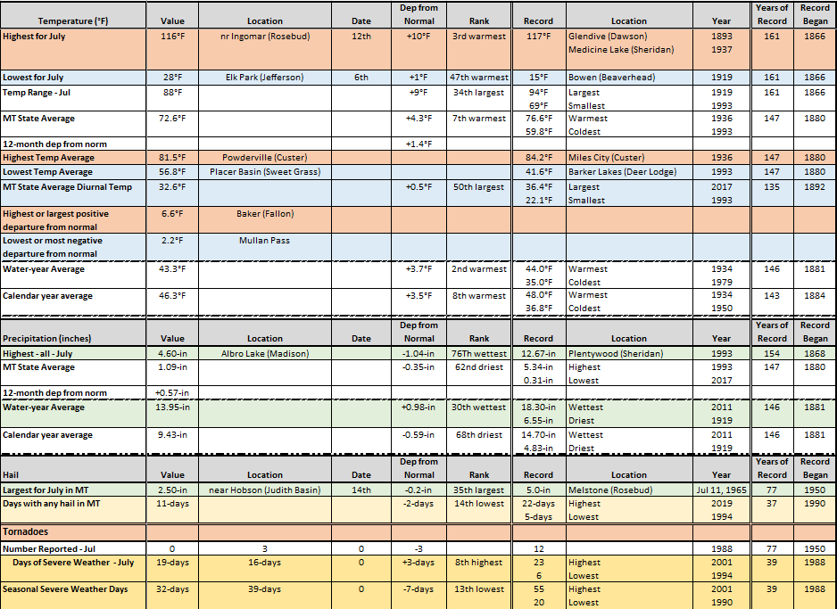
For MT, July 2026 max temp of 116F at Ingomar was 3rd warmest in MT. The monthly avg temp of 72.6F was the warmest since 2021. Water year avg temp was 2nd warmest and warmest since 1934.on the 26th was the earliest in the year since 1980. #mtwx
MT in July was warmer, drier and calmer than normal. The avg temp was 72.6F (4.3F abv norm & 7th warmest), precip avg was 1.09" (0.35" below norm), and winds avg was 7.1 mph (0.9-mph below norm & 2nd calmest). Warmest & coldest temps were 116F and 28F. #mtwx
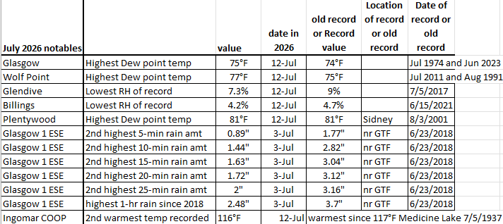
MT has had some very warm and dry, and humid weather in July 2026. The highest dew-point temp was tied at Plentywood on the 12th. The state's 2nd highest short-term rain amounts in less than one-half hour since 2018 caused flooding in Glasgow on the 3rd. See the table. #mtwx
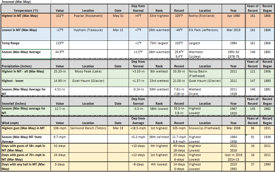
The spring season (Mar-May) in MT had warmer than normal temps (+2.5F), slightly less than normal precip (-0.14-in), less snow than normal (-3.5-in), and higher winds than normal. The highest gust of record for the period was set in Mar (106-mph at Salmond Ranch). #mtwx
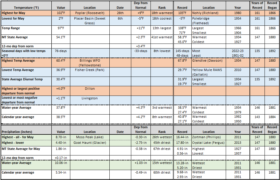
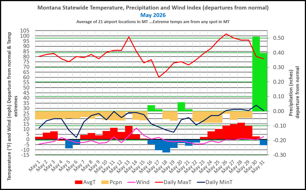
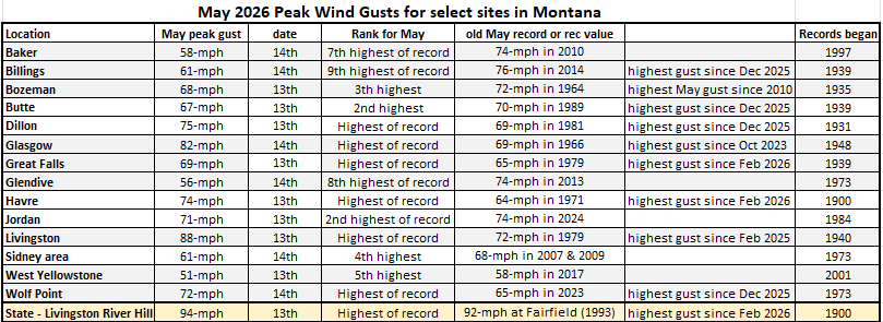
In May in MT, hail fell on only 1-day, the least since 1992. Wind gusts reached 94-mph near Livingston on the 13th, which set a record for May in MT. One tornado (landspout) was reported on the 13th near Big Sandy with strong and record May wind gusts over northern MT. #mtwx
For MT, the May 2026 max temp of 102F at Poplar on the 26th was the earliest in the year since 1980. Seasonal low temps below zero of 76-days was the lowest since 1980-81. Water-year avg temp is warmest since 1990, calendar year is the warmest since 2016. #mtwx
May in MT - The avg temp was 54.1F (2.3F above norm), precip averaged 1.86" (0.38" below norm), and winds averaged 9.3 mph (0.1-mph above norm). Warmest & coldest temps were 102F and 2F, the warmest in May since 1988. Most precip was on the last two days of May. #mtwx
Peak May wind gusts have set new monthly records at a few spots in MT. New monthly records were set at Dillon, Glasgow, Great Falls, Havre, Livingston and Wolf Point. The highest gust (94-mph), near Livingston, also set a new monthly May record for Montana. #mtwx
Wind gusts to 106-mph at Salmond Ranch, west of Choteau, MT, this morning has set a new March record for MT. The previous highest gust for March was 105-mph at Snowslip (Flathead Co) in 2008. #mtwx
Recent strong winds in MT set monthly March record highs at some spots. 104-mph gust at Judith Peak was 2nd highest of record for MT in Mar. Gusts over 70-mph were observed in 40 of 56 MT counties, with gusts of 80-mph or more in 23 counties. See table for notable spots. #mtwx
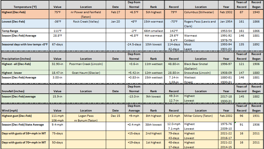
The winter season was mild with a lack of snow. The avg temp of 28.8F was 6.8F above normal and warmest since 1991-92. Snow avg was lowest since 1986-87. Strong wind gusts were seen more than usual. 75-days with gusts over 58-mph and 50-days over 75-mph somewhere in MT. #mtwx
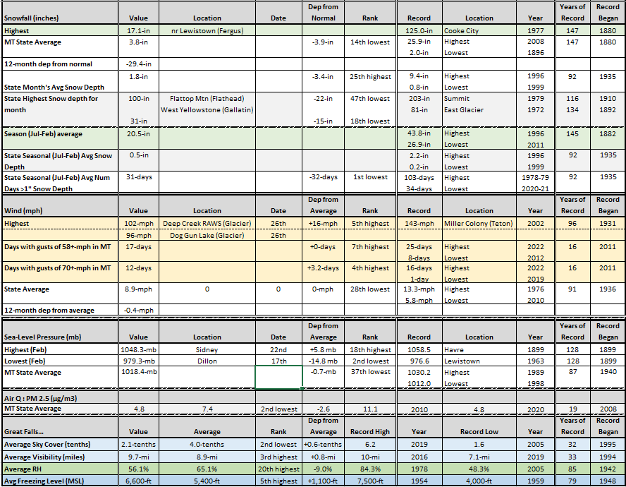
In MT, the Feb 2026 avg snowfall of 3.8" was lowest since 2016. Wind gusts reached 102-mph at Deep Creek on the 26th. Pressure at Dillon fell to 979.3-mph on the 17th, 2nd lowest of rec for MT in Feb. Avg freezing level of 6600-ft at Great Falls was the highest since 2016. #mtwx
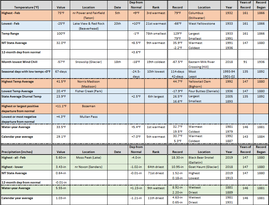
For MT, the Feb 2025 max temp of 75F near Fairfield and Power on the 5th was the earliest 75F of record for the state, warmest in MT since 1995. 67-days this season with lows below zero is the lowest since 1962-63. Water-year avg temp is warmest of record, old was in 1981. #mtwx
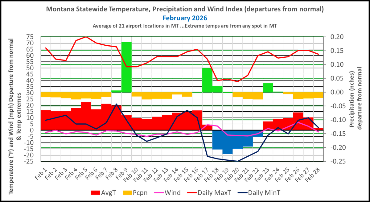
For February in MT, the avg temp was 32.0F (8.5°F above norm & 9th warmest), precip averaged 0.64" (0.01" below norm), and winds averaged 8.9 mph (normal). Warmest & coldest temps were 75F and -25F, a range of 100F. Temps averaged record warm in the SW. #mtwx
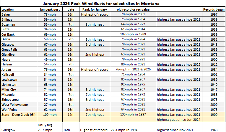
It's been quite windy in MT over the past month. Some record January gusts were seen in eastern MT on Jan 16th, at Baker and Jordan. Glasgow had their highest daily average wind speed of record for Jan on the 16th. See the table below for specific site info. #mtwx
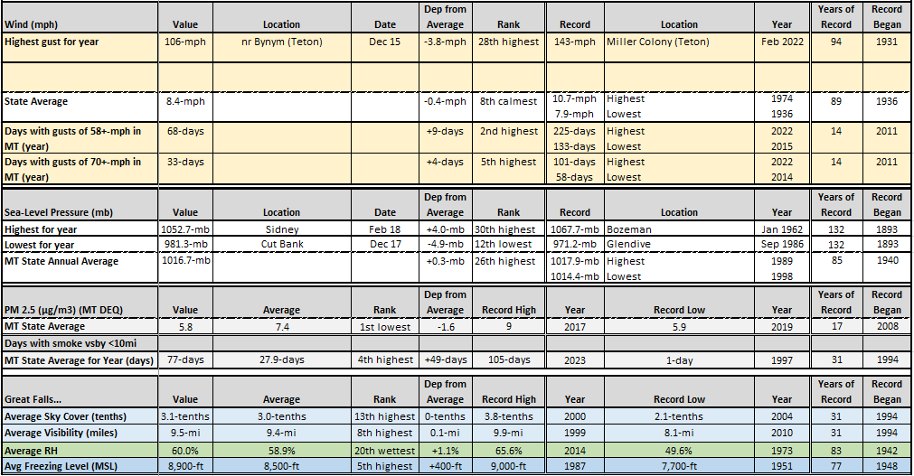
2025 in MT had a peak wind of 106-mph nr Bynum on Dec 15. There were 68-days with wind gusts of +58-mph at any spot in MT, the 2nd most. There were 77-days with smoke, 4th highest. Avg freezing level at Great Falls was 5th highest of record. Chart has info for 2025 for MT.#mtwx
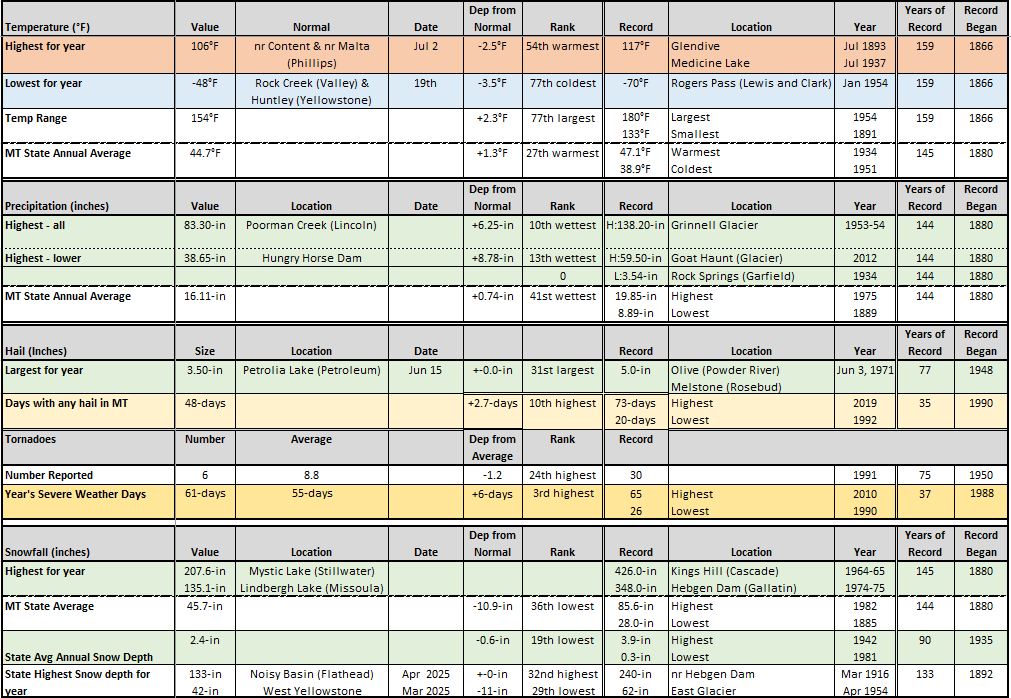
For 2025 in MT, the max and min temps were 106F and -48F. State's avg temp was 27th warmest. Some areas of NW MT were wet, ranking in the top 15 wettest years. There were 48-days with hail, the 10th most in a year, and 61-days with severe weather reported, the 3rd highest. #mtwx
In MT, the Dec 2025 state's avg snowfall of 8.8" was 2.3" below normal. Winds were a big story in Dec. Gusts of 70-mph occurred at some spot on 21-days, a record for any month. Pressure at Cut Bank during the wind storm was the 3rd lowest of record for the state in Dec. #mtwx
For Montana, the Dec 2025 low temp of -23F at Rock Creek was the 13th warmest of record. The state avg precip of 1.97" is the wettest since 1917, high site-specific precip - the highest since 1996. It's also a record wet water-year, and calendar year is wettest since 2019. #mtwx