Latest HRRR is showing our repeated rounds of showers and storms as we head into our Tuesday in Kentucky.
Heavy rain looks likely during the morning commute on Tuesday morning.
More rounds of storms in the afternoon will lead to a flash flooding threat! Also a low-end severe threat tomorrow afternoon! #KYwx
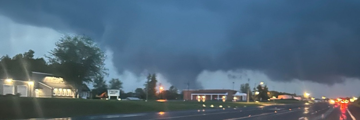
Time-lapse of the shelf cloud that moved through Bowling Green earlier today by our storm chaser @moebro7.
Nothing like seeing this on the of the hill⚡️ #KYwx
Flash Flood Warning for Logan, KY until 7:45 PM 6/9. Flash flooding from heavy thunderstorms is ongoing/expected; 1-3" rain with more possible. Turn around, don’t drown—avoid flooded roads, especially underpasses.
Flood Warning for Todd, KY until 6:30 PM 6/9. Flooding from excessive rainfall is imminent/occurring; rivers/creeks and low-lying areas may overflow. Turn around, don’t drown—avoid flooded roads and stay out of water.
Special Weather Statement for Monroe, Metcalfe, Cumberland until 5:00 PM 6/9. Wind gusts up to 40 mph may knock down limbs and blow unsecured items. Torrential rain may cause localized flooding. Avoid driving through flooded roads; seek shelter indoors.
4PM Central Update:
As Southern 1/2 of KY is getting rowdy with the ongoing storms, remember that airmass recovery is ongoing for the Northern 1/2 of KY and Southern IN. Some clearing is taking shape and still energy to monitor to spark more Showers and heavier storms along with the risk of flooding. Radar is clear and puffy Cumulus is draping over Indiana. Keep an eye out next several hours.
Special Weather Statement for Logan & Simpson until 4:45 PM 6/9. Wind gusts up to 50 mph and pea-size hail possible. Torrential rain may cause localized flooding. If outdoors, seek shelter indoors; don’t drive through flooded roads.
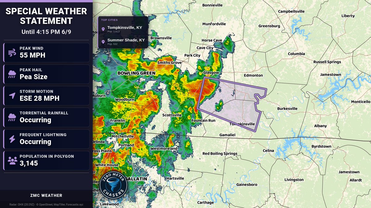
Special Weather Statement for Barren, Monroe, Metcalfe until 4:15 PM 6/9. Wind gusts 50-55 mph may knock down tree limbs and blow unsecured items. Torrential rain could cause localized flooding. Avoid driving through flooded roads; seek shelter indoors.
Special Weather Statement for Warren, Simpson, Allen, and Barren until 4:00 PM 6/9. Wind gusts up to 50 mph. Torrential rain may cause localized flooding; lightning. If outdoors, seek shelter inside; don’t drive through flooded roads.
HEADS UP for Southern KY & Middle TN:
Slow moving heavy showers continue to drop Southeast along & South of the Cumberland Parkway and US 68-80 corridor. PWat values over 2” in a moisture laden airmass will likely cause localized flash flooding with rainfall rates over 2”/HR at times. Rainfall amounts can be up to 3” in localized areas.
Please report if you see Flooding.
Flash Flood Warning for Warren, KY until 6:15 PM CDT. Heavy rain may cause flash flooding of creeks/streams, roads, underpasses, and low-lying areas. Turn around, don’t drown—avoid flooded roads and report flooding if safe.
Special Weather Statement for Warren, Allen, and Barren until 3:45 PM 6/9. Wind gusts up to 40 mph. Torrential rain may cause localized flooding; lightning ongoing. If outdoors, seek shelter inside and avoid driving through flooded roads.
Special Weather Statement for Butler and Warren until 3:45 PM 6/9. Wind gusts up to 40 mph and pea-size hail possible. Torrential rain may cause localized flooding. Seek shelter indoors; don’t drive through flooded roads.
Flood Advisory for Allen, KY & Others until 8:45 PM CDT. Heavy rain may cause localized flooding, water over roads, and ponding in poor drainage areas. Turn around, don’t drown—avoid flooded roadways.
Special Weather Statement for Butler, Logan, Warren, and Simpson until 3:15 PM 6/9. Wind gusts up to 40 mph and torrential rain may cause localized flooding. Lightning possible. If outdoors, seek shelter inside; don’t drive through flooded roads.
<2:15 Central RADAR UPDATE>
Strong storms, not severe, impacting Southern Warren (S of BWG) and Franklin right now with gusts up to 40 moving SE. More showers have popped up in West-Central Ky as well since the sun has come out to destabilize our Airmass. Keeping eyes close farther West near Paducah as that activity is closer to the better wind energy with the Low as those could become Severe shortly.
Next several hours, more storm clusters will likely increase into Southern Indiana as they trek Southeast across the River.
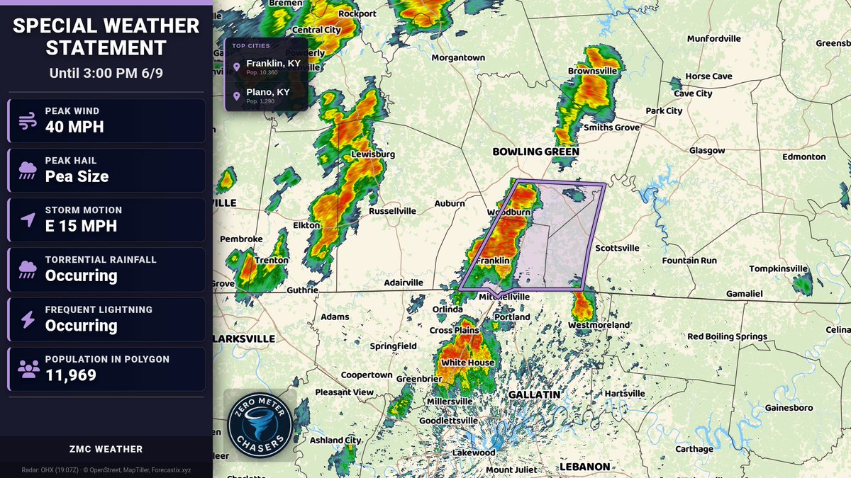
Special Weather Statement for Warren, Simpson, Allen until 3:00 PM 6/9. Wind gusts up to 40 mph may knock down tree limbs and blow unsecured objects. Torrential rain may cause localized flooding. Avoid driving through flooded roads; seek shelter indoors.