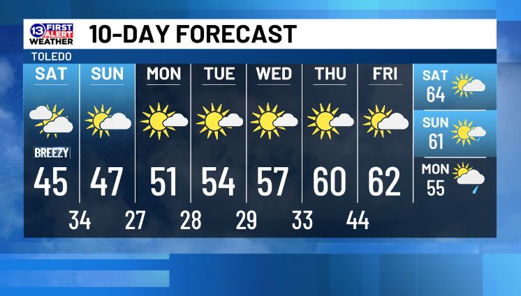
The TREND is your friend...if you like warm weather! 4 of the next 10 days include high temps in the 60s! High temps will be in the 40s this weekend, 50s early next week and 60+ later next week.
This weekend will be chilly, but next week is looking gorgeous by November standards. Lots of sunshine, no rain, light winds, and high temps gradually rising through the week. However, nighttime lows will be cold through early Thursday, then we'll reach the mid-60s next weekend!
FEELING FRIGID TONIGHT 🥶 Actual temps are forecast to drop into the upper 20s while wind chills should bottom out in the mid-20s. This northerly wind will also persist into Saturday and early Sunday, so the chill will linger for much of the weekend. Then we'll warm up next week!
DRYING OUT: Once any of these lake-effect showers and flurries move out tonight, we're looking at a long stretch of dry weather. There is a small chance for a rain shower next weekend, but currently we're favoring mainly dry conditions during that time, plus highs in the low 60s!
"The sea was angry that day my friends..."
As this stout north wind continues to blow, Lake Erie will stay very choppy into the weekend. Waves over 5 feet are possible east of the islands through Saturday, plus waterspouts could develop underneath any low clouds through Sunday.
GOOD NEWS! Dry conditions for our tree lighting at Levis Commons Town Center this evening, but it'll be chilly. Lake-effect rain and snow showers will continue in our eastern counties past sunset, but they should wrap up by midnight tonight.
Democratic Sen. Chris Van Hollen of Maryland said Thursday that he will run for Senate Majority Leader in the next Congress, setting up a challenge to Democratic Leader Chuck Schumer after the party swept to power in the midterm elections.
Need to know "stuff" in the FIRST ALERT 7-Day Forecast:
1) Cold, a bit breezy with rain & snow showers Friday
2) Cool this weekend
3) Big warm up next week! Cold nights, but highs by close to 60 by Thursday