The DSL is hiring a new associate director, someone to help lead the lab and coordinate all the GIS work for projects like American Panorama and Mapping Inequality. If you're interested, info's at https://t.co/oHfRtXpMHh . And pass along to anyone you think might be interested.
The Massachusetts Historical Society issued a call for proposals for scholars in the digital humanities to workshop work-in-progress as part of their Shapiro Digital History Seminar series. These seminars are really productive. https://t.co/5YbKiC5luM
Which is one reason we (with @BrentCebul) created https://t.co/bJANGWawct so we could help complicate this history with another DH project and dataset on a federal program that was rife with racism too and more materially impactful than HOLC's maps. 11/11
This is a smart and very timely piece addressing some questions that I've been thinking about too. @justinmadron and I wrote a paper related to this for the APS's Open Data Symposium last spring 1/11
https://t.co/GwSKtqgxpD
So, while I think @robgioielli's piece might not give enough credit to the nuances and qualifications of some of this literature, couldn't agree more that we need more work, and I'd say datasets, on real estate, urban and housing policy, and race in 20th century. 10/11
I am leading the workshop "Something Mappy This Way Comes: An Introduction to Digital Mapping Technologies" through @VisResAssn starting November 1st. It will be a crash course in available digital mapping technologies including browser tools by @Mapbox
https://t.co/EXAXDvrHfJ
Working on Mapping Inequality V3 with new maps for smaller towns. Map of Bristol VA makes me want to laugh & cry about links between past & present-today's MLK Blvd jumps out on a narrow area surgically redlined when he was ~10 years old.
@DextraordinaryH @PaulRobbins15 We have a lot of this data in Renewing Inequality: https://t.co/mappcMdo7e project data on GitHub: https://t.co/Jw64qZ9d0n Would love to see more use of the data, which is more complicated than the HOLC data but has as much potential.
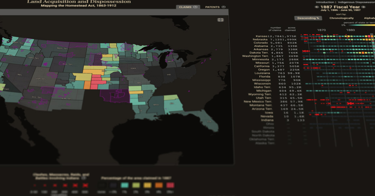
Explore “The #HomesteadAct of 1862”. By 1912, homesteaders had transformed more than 125 million acres from public lands to private property. While Native Americans were dispossessed of large portions of the American #West. @urichmond @WilmJulius #maps
https://t.co/eZyREMiURT
@econhist_allday @Stuart_in_DC @ToddMichney And paper from Chicago Fed economists makes a strong if inferential argument that the HOLC maps impacted wealth inequality (perhaps through the FHA): https://t.co/vWcxaaiUdS
@ToddMichney @econhist_allday @Stuart_in_DC @TheIslandInn The Cincinnati map is available from OSU library. It’s pretty rudimentary but is interesting in having HOLC loan data. https://t.co/jUaUcBncJv
I so admire the YIMBY movement. This fundraising effort is trying to get the full HOLC archive at the National Archives digitized, in part to grow and expand Mapping Inequality https://t.co/HDbjypBNec