Sunday looks drier and hotter in western Oklahoma as our storm system exits. Scattered storm chances continue from central into eastern Oklahoma. Monday is a drier day and south winds kick up, this will allow temperatures to heat up. #okwx
Radar Update 4:16 PM - Scattered to widespread showers and storms are moving across parts of Oklahoma today. Most widespread rain is in the east. Strongest storm with some wind is near Ardmore to Sulphur. Rain chances stick around this evening and tonight. #okwx
61% blow-by rate in the Finals on 18 drives Wemby defended. Not that this is a useful stat or stat we hear much about anymore.
But we all remember how much it was talked about with Luka vs Boston in the Finals which was 58% btw...
Radar Update 9:18 PM - Showers and thunderstorms in southwestern OK continue to develop and spread slowly to the east and northeast. Some of this activity may spread into the metro over the next several hours. #okwx
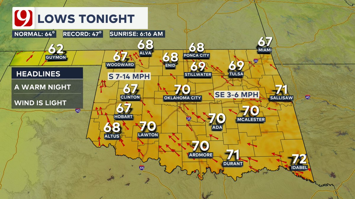
Sct'd storms continue this evening into the overnight. Lows fall into the upper 60s to low 70s overnight. Tropical air & upper level low moves overhead tomorrow with clusters of t'storms likely. Severe wx threat is low but locally flooding is possible. Highs in the 80s #okwx
3:20 Update: Continue to track showers & storms across western Oklahoma. A severe warning has been issued for the storm over Ringrood with the threat of 1" hail & 60 mph winds. The biggest threat is dangerous lightning & very heavy rains with the slow-moving storms. #okwx
Friday 2:15 pm Update: Tracking showers & storms across western Oklahoma with dangerous lightning & locally very heavy rains. One severe storm capable of 1" hail & winds to 60 mph is near Cleo Springs. Activity is moving NE at 15 mph. #okwx
Friday 1:15 pm Update: Scattered showers & storms are developing with the heating of the day across th area. The largest cluster of heavy rain, lightning, & gusty winds is near Hobart & Altus, moving northeast at 20 mph. Temps are in the 80s & 90s across the state. #okwx
Heat and humidity returns tomorrow, and rain chances increase tomorrow night. Rain chances remain fairly low through tomorrow. The main round of rain and storms arrives Saturday bringing the greatest rain chances to the Oklahoma. #okwx
Radar Update 2:29 PM - Scattered showers and storms continue in Western/Northern Oklahoma. Occasionally these storms have been able to pulse up to severe strength with near 60 mph gusts and penny-nickel size hail. #okwx
Radar Snapshot 1:14 PM - Isolated to scattered showers have developed from Western to North-Central Oklahoma. Most are very weak, though the storm southeast of Helena may have some gusty winds and small hail. it is also the only storm with any lightning present right now. #okwx
Storm system #2 arrives on Saturday with better rain & storm chances across the state. Scattered storms could produce some locally heavy rain and help keep afternoon highs in the 80s over the weekend. By early next week, rain chances fade away as highs return to the 90s. #okwx
Rain for some but not for all the next 48 hours as our first storm system stays to the west. Rain & storms mainly stay in far western OK this evening with some localized heavy rains. We're between systems the next two days, with only a stray storm possible. #okwx
I appreciate the transparency in the outlook messaging (see highlighted part of the picture in the quoted tweet). That should be included in every SPC D1 morning outlook until this changes.
Been harping on this since April, and it's true. Early afternoon balloon launches from offices that can't do the morning launches does not change the fact that not having the morning launches is bad for forecasts.
The lack of morning weather balloons launched across the western and central U.S. is having a real, tangible impact on degrading forecast quality.
We can't look at weather balloon data that doesn't exist. We can't pump nonexistent data into models. We can't rely as heavily on models that don't "know" what's happening above our heads.
Today's severe weather forecast is less certain because we don't have weather balloon data to confirm the strength of jet stream winds aloft.
This is extremely frustrating, and is the result of logistical, organizational, political and budgetary decisions.
Radar Update 3:04 PM - Scattered shoers and thunderstorms have developed in the Panhandles and along the state line. Occasional gusty winds, small hail, and lightning from these storms. We'll see how far east they're able to develop. Storm motions are mainly due north. #okwx
Rain chances increase late week into the first half of the weekend with a storm system that moves through. This will cause more cloud cover & heavy rain chances, but plenty of dry hours. Some of the storms could be strong, but the severe weather threat looks low. #okwx