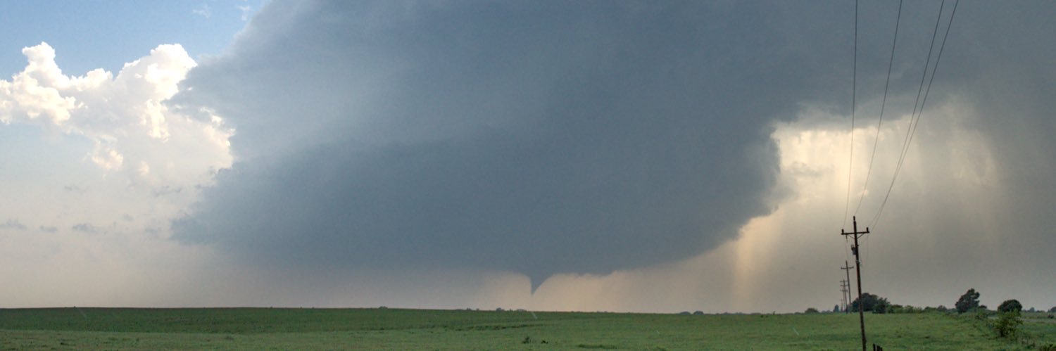
@Brady_Wx@CameronJNixon In addition to everything else noted here, the topography at that exact spot is also substantial. Tor begins at the head of a small valley oriented to channel inflow. Not something we could’ve ever accounted for in a forecast
2) RRFS/REFS notably less bad in some verification metrics than it looks visually—there’s value in ignoring explicit representations of thermonuclear megawedges, and broadly considering timing/placement/coverage/env
3) MPAS-based v2 in development looks quite a bit better
Not speaking for anyone here but I’ve looked at RRFS in forecast activities and in aggregate stats over multiple testbeds. Three things have stood out:
1) Yes, FV3 core at CAM resolution has weird intrinsic issues that people smarter than me can’t totally eliminate
The SPC REFS adds the HRRR and removes the 2 worst performing REFS members. This version of the REFS outperformed the HREF in 2025. This version of the REFS will be displayed on the SPC webpage in place of the HREF when it is retired.
Red River cluster's environment and large-scale pattern, far downstream into MS, raise red flags for MCS sig wind conditional on maintenance and upscale growth. Steep midlevel LRs, moderate deep shear, very fast upper-troposphere flow...
@CameronJNixon Then you have the complex of LMs going RM back west of Elmore City about 00Z. Wider storm coming out of the merger, little more dry air in the column—so it immediately outflow bombs itself 😂
Four? possible modes in OK, roughly by confidence/severity...
(1) Secondary WF, C OK to SE OK
(2) Primary WF, KS border to ~Tulsa to AR
(3) Dryline, C OK to N TX
(4) Stationary bdry, NW OK to C OK (FV3/RRFS idea)
Saturday is a touchier and more complicated low-level evolution than I'm used to dealing with around here. One or more mesolows, dryline, secondary/effective warm front, all uncapped, multiple meso-beta pockets of high-end environments, CAM CI signals scattered everywhere...
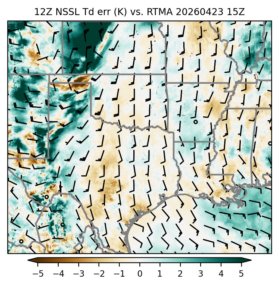
Early model error notes...dews slightly outpacing even the MYJ members in the OK moist sector; ARW has best handle on current temps S of I-40; HRRR a little too warm both sides of dryline
Can't help noticing that the sustained ascent during the afternoon is the opposite of similar trajectories for some of the conditional days that have not popped this spring
Sure would like a 12Z MAF raob. Trajectories 12-23Z today ending in the lower EML over Pocasset.
Been running HYSPLIT on a lot of these conditional cap days and realizing just how limited local morning obs are. That air is long gone at showtime. Need upstream info.
Actual ingredients-based forecasting: moisture, instability, shear, and a mysterious fairy hiding in the models’ omega bars who *occasionally* shows up where junior dynamics told you she should be
Sunday has a fairly consistent signal for a SEward diving MCS E OK early AM, leaving remnant OFB w/ unique orientation to dryline reminiscent of 5/9/16
Analog ends there though; 5/10/16 00z main trough axis was in C KS, vs. 00z Mon in NM. Timing remains a problem...
-- About Recent SPC Forecast Performance --
The story below from NBC, and others on the less-than-2% outlook's tornado occurrences in KS, some of which also note the watchless tornadoes in Lower MI earlier this year, grossly oversimplify reality on the SPC forecast desk. They rely on a lot of idle speculation by people who haven't worked it and just don't know.
I've done SPC outlooks for decades, and as usual, will be brutally honest here. I know how it works there, from the inside. Read and learn. These insights don't lend themselves to 10-second attention spans nor quick sound bites. So this is long. Don't "TLDR" this post if you really care about actually learning how it works.
I'll put the bottom line here, near the top: Chances are there is ***no smoking gun***. That may not suit rage-baiting and click-baiting, but it's simply reality. That's the lede. Here's the rest...
Why no smoking gun? Far too much goes into a forecast to lay "blame" at any one factor. Like it or not, bad forecasts happen. They always have and always will. The aim is to reduce them over years, knowing that some events are so localized and/or extreme that both human and computer forecasts can't always nail them down. That's reality.
Until forecasters have extremely high-resolution sampling of the real atmosphere on scales storms form and operate (a few miles), even the most sophisticated models, both from traditional, physics-based and AI/statistical packages, will suffer sometimes with localized subtleties. Guess what's involved in forming a dryline storm here vs. somewhere else, amidst capping and modest broader left? You got it, friends, localized subtleties.
Yes, observational balloon data were missing and are, in bulk, important to models. Several scientific papers have shown this. *Maybe* that mattered here. Maybe it did not. Satellite-derived data matter too, and often more. How important was the lack of radiosondes to this case on this day? We don't know. As Alan Gerard alludes in his quote in the NBC story: that needs to be studied (using data-denial experiments). Until then, it's speculation to say how much that altered output at any of many levels of the atmosphere, from models that *variably* and *incompletely* influenced the outlook's positioning here.
*Numerous* models are examined every forecast cycle, especially early-arriving deterministic ones, ensembles, and newer/quickly computed AI packages that work off historic pattern recognition. How they may be affected by missing input data can vary from model to model and by data type. It can be such a dense black box that such effects are simply unknown to the forecasters. We're not, and cannot be, privy to every nook and cranny of their physics or statistical equations. Forecasters often notice and account for model biases, but where they come from can be quite complex and not just tied to one factor.
Between that and diagnostics that should precede models, it can be a veritable firehose of information, on deadline. With time, experience, on-shift mentorship of the leads and senior outlookers, and training, forecasters get better at situationally prioritizing what to drink from that firehose, when, how, and why. It is simply impossible to examine every possible diagnostic and prognostic detail from every data source.
Models are not all that go into a forecast. So do diagnostics: analyses of surface and upper-air data. The latter factually do have holes that may cause analysis to miss subtle features, but was that true here? We don't know yet. Other diagnostics, such as satellite and radar-indicated features, and intangibles such as reading, research, forecaster experience, and intuition with specific situations, also play a role.
It's even more speculative, and likely inaccurate, to say the lack of greater staffing affected the outlooks in these cases so far. [That isn't to say it can't, or won't, the rest of the season.] Though I recently retired, and was not a participant in these forecasts, I do know the principals involved. Everyone who did the outlooks for the KS day were working normal 8-hour shifts and not overtime. If "exhaustion" or "fatigue" were factors, it comes simply from the nature of rotating shift work, which is documented to be unhealthy mentally and physically, and a known carcinogen. Don't knock it 'til you've done it.
Yes, with two retirements last month, 5 openings (out of 10 positions or 50% vacant) are on the SPC outlook/mesoscale desk. That is unprecedented. They need to be permanently filled with full-time forecasters, stat! A lot of fill-in shifts by both managers (one of whom is an extremely sharp and highly experienced forecaster), and less-tenured forecasters, will be needed until those are filled. Results may vary.
That won't help, and yes, it might hurt! But it's premature and speculative to pin any single forecast performance so far, or the rest of this season, just on that. Again, forecasts sometimes simply miss. SPC has a well-earned reputation for, and internally motivated standard of, excellence. Excellence is not synonymous with perfection. Even I had some bad forecast decisions I'd like to have back. ;-)
Outlooks at SPC do not happen in a vacuum. One or two names may appear thereon, but it's a team forecast. Internal collaboration is required. External coordination with involved WFOs is strongly encouraged if major changes are being made to a previous outlook. Otherwise, there is not enough time to coordinate every part of every outlook line with every involved WFO, who themselves also are busy with other tasks. Every minute doing that is a minute not spent doing meteorology. So there must be a balance achieved on deadline.
I don't know for sure here, but it is possible that the 2% and 5% tornado lines that drove the "MRGL" and "SLGT" areas were suggested by, or compromised with, the WFOs serving eastern KS. Only they and the SPC forecasters on duty could verify either way.
And even everything I've typed is just a superficial, condensed summary of the outlook forecast process. I did thousands of them, both the graphics and long-form text discussions, so give me the benefit of the doubt here.