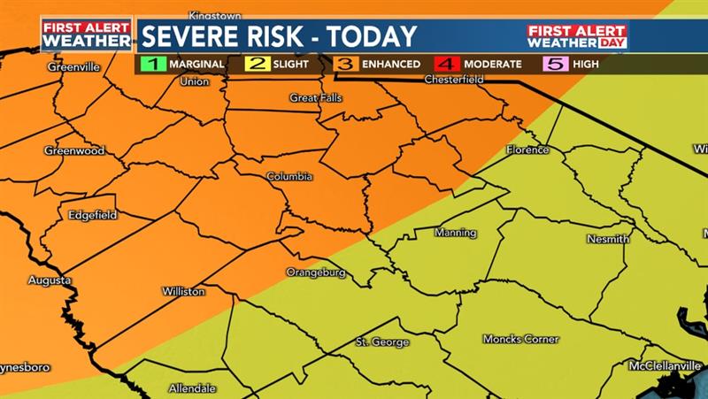
Stay weather aware today! Strong winds are our primary concerns for the storms later this afternoon/evening.
Today is a First Alert Weather Day. The Storm Prediction Center has a good section of the Midlands under a level 3 "Enhanced" risk for strong storms. #scwx#storms#wis
Watching the tropics as a system off the coast of Africa moves northwest into more favorable conditions it has a better chance of development. Now at 40% during the next 7 days with an emphasis for this weekend. https://t.co/zRPe1lwkpK #tropics#wis
TROPICAL UPDATE: There's a 10% chance of a weak low pressure system developing off the coast of SC/GA/FL in the next 7 days. Here's the latest:
https://t.co/zRPe1lwkpK #tropics#wis
TRACKING some potentially strong storms Thursday. Expect winds and heavy rain within the storms. Read more about the First Alert Weather Day here: https://t.co/zRPe1lwkpK #storms#scwx#FirstAlert
AIR QUALITY WARNING for portions of the Midlands until 10am for the smoke created by the fires burning in NW Canada.
https://t.co/zRPe1lwkpK #smoke#haze#scwx#WIS
AIR QUALITY will be a bit worse tomorrow with most of the Midlands under "unhealthy for some" during the afternoon hours. This means if you have sensitivity to smoke particulate you need to limit your time outdoors. https://t.co/zRPe1lwkpK #smoke
SHOWERS AND STORMS are still possible for the rest of the week and we see highs in the low 90s with high humidity.
https://t.co/zRPe1lwkpK #scwx#rain#heat
FIRST ALERT Weather Day for Tuesday's dangerous heat. There's also a chance of some afternoon storms.
https://t.co/zRPe1lwkpK #heat#hot#wis#FirstAlert#scwx
SMOKE/HAZE THEN HOT: We still have moderate air quality for your Thursday. Then dangerous heat for this weekend with First Alert Weather Days posted!
https://t.co/zRPe1lwkpK