RAVAN AIR is a nationwide underground & aerial inspection service provider for the oil & natural gas, landfill, utility, government & construction industries.
Mapping underground! 🏗️ RAVAN AIR delivers high-precision 3D mapping to optimize Michaels Trenchless Inc. projects. #3DMapping
See how: https://t.co/E3JNDLE0X5
Mapping a massive 54" pipeline in Nebraska demands precision. RAVAN AIR delivered accurate 3D data safely and efficiently. 🛠️#RAVANAIR
🔗 https://t.co/wWExsKvrYk
Building a more resilient NYC! 🗽 RAVAN AIR is delivering high-precision subterranean mapping for the Newtown Creek CSO Storage Tunnel project. #NYC#Infrastructure#Mapping
🛠️ https://t.co/YJ2FBW3cB4
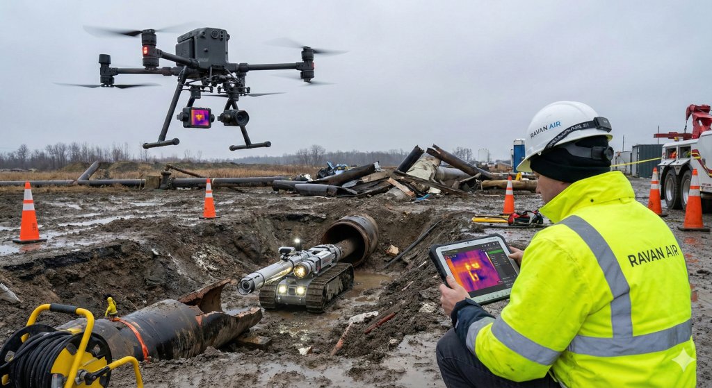
Seconds count in a crisis. 🚨 RAVAN AIR uses drones & probes for rapid, precise data during disaster & leak assessments. #EmergencyResponse#Safety#Tech
🛠️ https://t.co/YSKLDDGwbe
Speed meets precision! 🛠️ RAVAN AIR mapped a 4” gas line in <3 hours with 24-hour data delivery. High-fidelity 3D mapping for safe, efficient ops. 📊 #Mapping#GasPipeline#RAVANAIR
https://t.co/RrRziF2y8z
Stop leaving money on the table! ☀️ RAVAN AIR’s aerial thermal mapping boosts solar ROI and safety by spotting invisible hot spots. 🚁🛠️ #SolarEnergy#Drones#OandM
https://t.co/mkIREIz2PC
Wastewater infrastructure is the backbone of our communities. 💧 RAVAN AIR ensures it stays strong with high-tech inspections.
🛠️ https://t.co/TKCfsLw5KJ
#Wastewater#Infrastructure#RAVANAIR
Reach new heights in safety! 📶 RAVAN AIR uses advanced drones for cell tower inspections, delivering precise data without the risky climbs. #Wireless#Drones#RAVANAIR
🛠️ https://t.co/m4ES8mjWX6
High-voltage demands high-tech. ⚡ RAVAN AIR helps transmission utilities maintain the grid with unmatched accuracy and safety. 🛠️#ElectricGrid#Safety#RAVANAIR
https://t.co/SAe0AUEEZD
Keeping neighborhoods safe! 🏘️ RAVAN AIR uses elite tech to inspect distribution gas lines, ensuring reliable energy for every home. #GasLines#Utilities
🔗 https://t.co/RLFMBXH3yA
Drilling deep? 🏗️ RAVAN AIR brings precision to fracking and drilling with high-res mapping and data-driven safety insights.
Let's optimize your ops: https://t.co/L01P8KweSa
#Drilling#Energy#Fracking
Building or maintaining an oil or gas pipeline?🛢️RAVAN AIR provides the elite data needed for safe, efficient oil & gas pipeline operations. #OilAndGas#Pipelines
Your partner in safety: https://t.co/S3QFnOOBHv
See what the eye can’t! 🌡️ RAVAN AIR’s aerial thermal imaging detects leaks & heat loss with total precision. Protect your assets from above: https://t.co/DwCE0F35U6 #ThermalImaging#DroneTech
See the big picture! 🛰️ RAVAN AIR’s aerial GIS mapping provides the high-res data you need for smarter, more precise planning. #GIS#AerialMapping#Data
Elevate your project here: https://t.co/5BUQqQe18t
Stop the guesswork. 🎥 RAVAN AIR’s CCTV pipe inspections offer high-definition clarity for your underground assets. See everything with precision: https://t.co/VMwxSTvxCA
#CCTV#Infrastructure#Maintenance
Safety is non-negotiable. RAVAN AIR’s cross bore inspections identify utility risks before they escalate. 🛡️ Secure your assets with precision: https://t.co/X355jAUAEz
#CrossBore#PublicSafety