A Shift in the Monsoon Pattern 🌧️
While the season has begun quietly, our latest analysis on the https://t.co/SBXmEtWYKX platform indicates a significant change on the horizon.
A low-pressure circulation is currently forming in the Bay of Bengal. As this system develops, it is projected to draw in substantial moisture, driving heavy, torrential rainfall across the Indian landmass starting July 2nd.
Stay ahead of the changing conditions and track real-time meteorological developments with us.
#WeatherEx #Monsoon #Meteorology #WeatherForecast #DataAnalytics #IndiaWeather
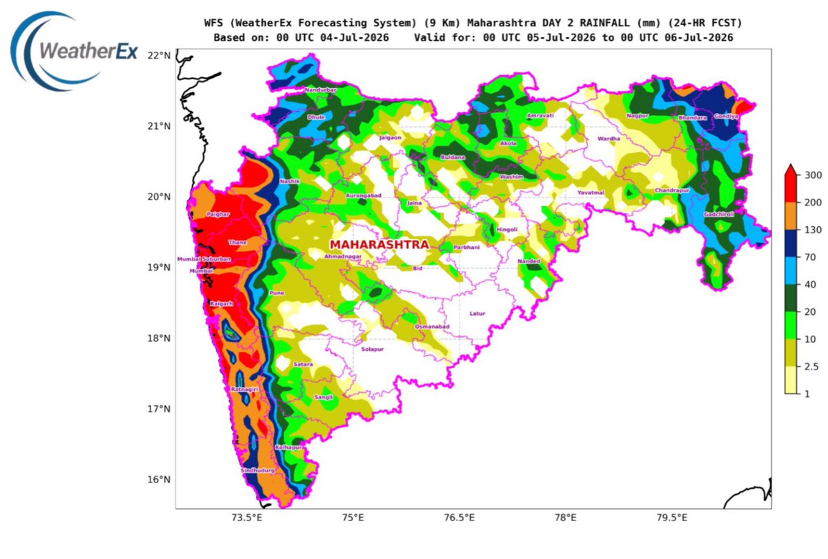
WFS Rainfall Forecast Update | 4–6 July 2026
The latest WFS – WeatherEx Forecasting System run indicates a very active monsoon phase over the west coast, with Mumbai, MMR, North Konkan, and the Western Ghats likely to remain under heavy to very heavy rainfall activity during 4–6 July.
For Mumbai and adjoining MMR, rainfall has already picked up on 3 July and 4 July, and the spell is expected to intensify further. T
Next 90 minutes: what will be the rain scenario in Mumbai, developed by @akshaysunil172 in collaboration with @IMDWeather@RMC_Mumbai updated at https://t.co/m2FyUOLW2H . This system works subject to real time update of Mumbai radar data. @ClimateIITB@iitbombay@mybmc
India Rainfall Forecast | 3–4 July
WFS — WeatherEx Forecasting System 9 km forecast indicates an active monsoon phase across large parts of India during the next 24 hours.
The strongest rainfall signal is seen along the Konkan–Goa–coastal Karnataka belt, with heavy to very heavy rainfall likely over parts of Mumbai–Konkan, Goa and adjoining Western Ghats. Rainfall is also expected to remain active over Maharashtra, Madhya Pradesh, Chhattisgarh, Odisha, Telangana and parts of Gujarat, with scattered moderate to heavy spells.
The Bay of Bengal sector also shows strong convective activity, supporting rainfall over Odisha, coastal Andhra Pradesh, West Bengal and the Northeast, including Assam, Meghalaya, Mizoram, Tripura and adjoining hill regions.
Overall, the monsoon circulation remains well organised, with moisture feeding both from the Arabian Sea branch along the west coast and the Bay of Bengal branch towards east-central and northeast India.
Mumbai, Konkan, Goa, coastal Karnataka and parts of central India should remain on watch for intense short-duration rainfall, local waterlogging and travel disruptions.
Forecast guidance: WFS — WeatherEx Forecasting System
Platform: https://t.co/SBXmEtWYKX
⚠️ Rainfall Forecast Alert | 4 July 2026
The WeatherEx 9 km NWP forecast indicates widespread monsoon rainfall across several parts of India.
🔴 Heavy to very heavy rainfall is likely over:
• Konkan–Goa and adjoining Western Ghats
• Parts of Maharashtra, Madhya Pradesh and Chhattisgarh
• Odisha and adjoining east-central India
• Coastal Karnataka and Kerala
• Assam, Meghalaya and parts of Northeast India
Intense rainfall pockets may lead to localised flooding, waterlogging and reduced visibility. Residents in vulnerable areas should remain alert and follow official advisories.
Forecast based on the 00 UTC model cycle of 3 July, valid for the 24-hour period ending 00 UTC on 4 July 2026.
Mumbai is on alert. ⚠️
Visit https://t.co/SBXmEtWYKX
A tentative red alert like condition on July 4th–5th, with intense rainfall expected across the city. And this may just be the beginning, forecasts indicate a sustained wet spell with more rain lined up through the week.
For businesses, infrastructure teams, and city operations, this is a critical window to prepare for potential disruptions, flooding risks, and operational challenges.
Staying informed isn’t optional, it’s essential.
#MumbaiRains #WeatherAlert #RedAlert #Monsoon2026 #RainfallWarning #UrbanResilience #DisasterPreparedness #WeatherForecast #ClimateAwareness #MumbaiWeather
⚠️ Mumbai Rainfall Alert | 4–6 July
Rainfall is expected to intensify from 4 July, with very heavy rain across Mumbai on 5 July. The peak is likely during this period, when isolated wards may receive extremely heavy rainfall exceeding 200 mm.
Waterlogging, traffic disruption and localised flooding are possible. Avoid unnecessary travel during intense spells and follow official advisories.
#MumbaiRains #MumbaiWeather #Monsoon2026 #WeatherEx
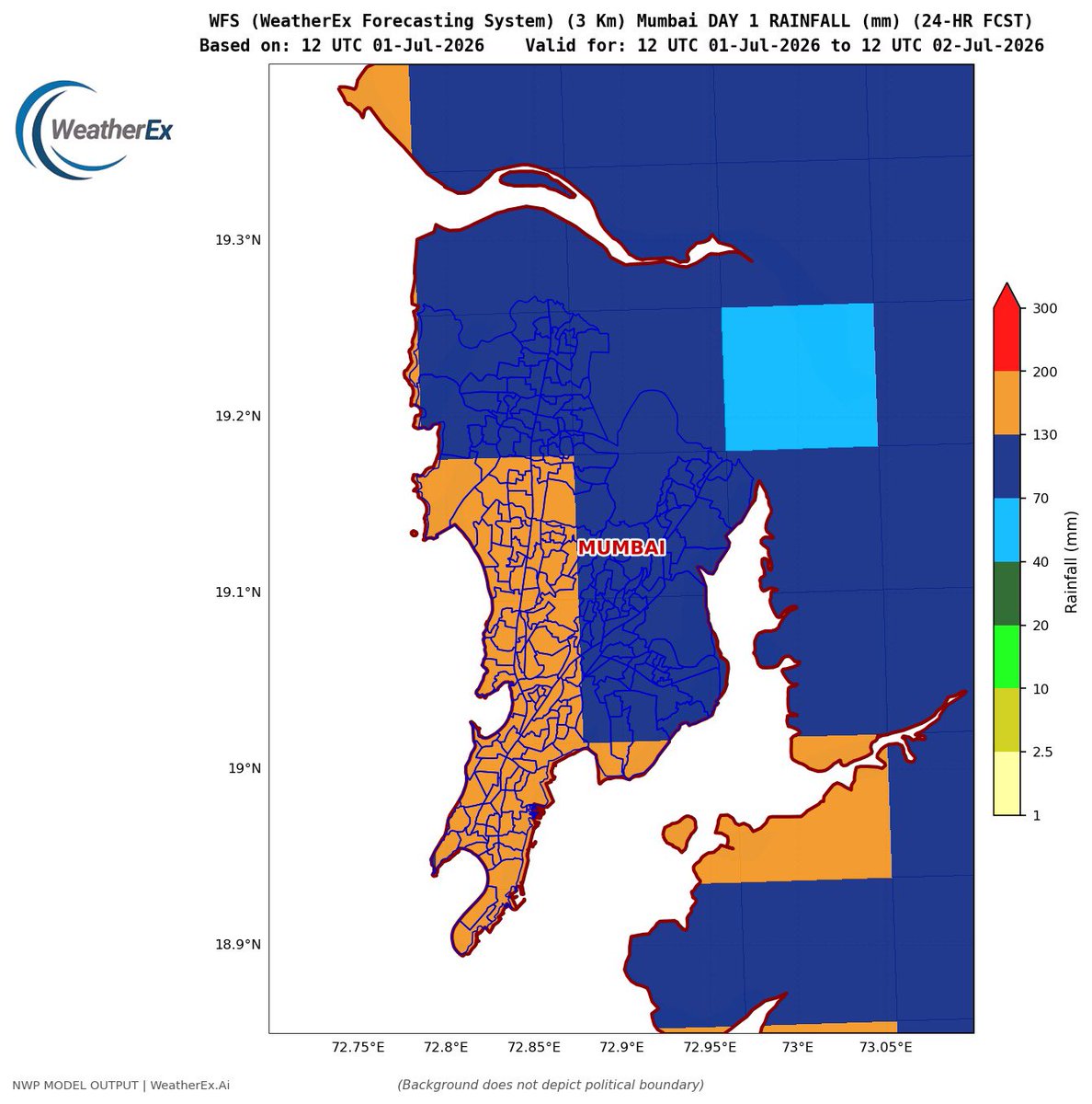
WFS 9 km forecast indicates widespread moderate to heavy rain across Mumbai during the 24-hour period ending 5:30 PM on 2 July.
Mumbai city and the western suburbs may receive very heavy rainfall, with a few pockets seeing intense spells. Heavy to very heavy rain is also likely over the eastern suburbs, Navi Mumbai and nearby areas.
Waterlogging and traffic disruption are possible in low-lying locations, especially during the more intense spells.
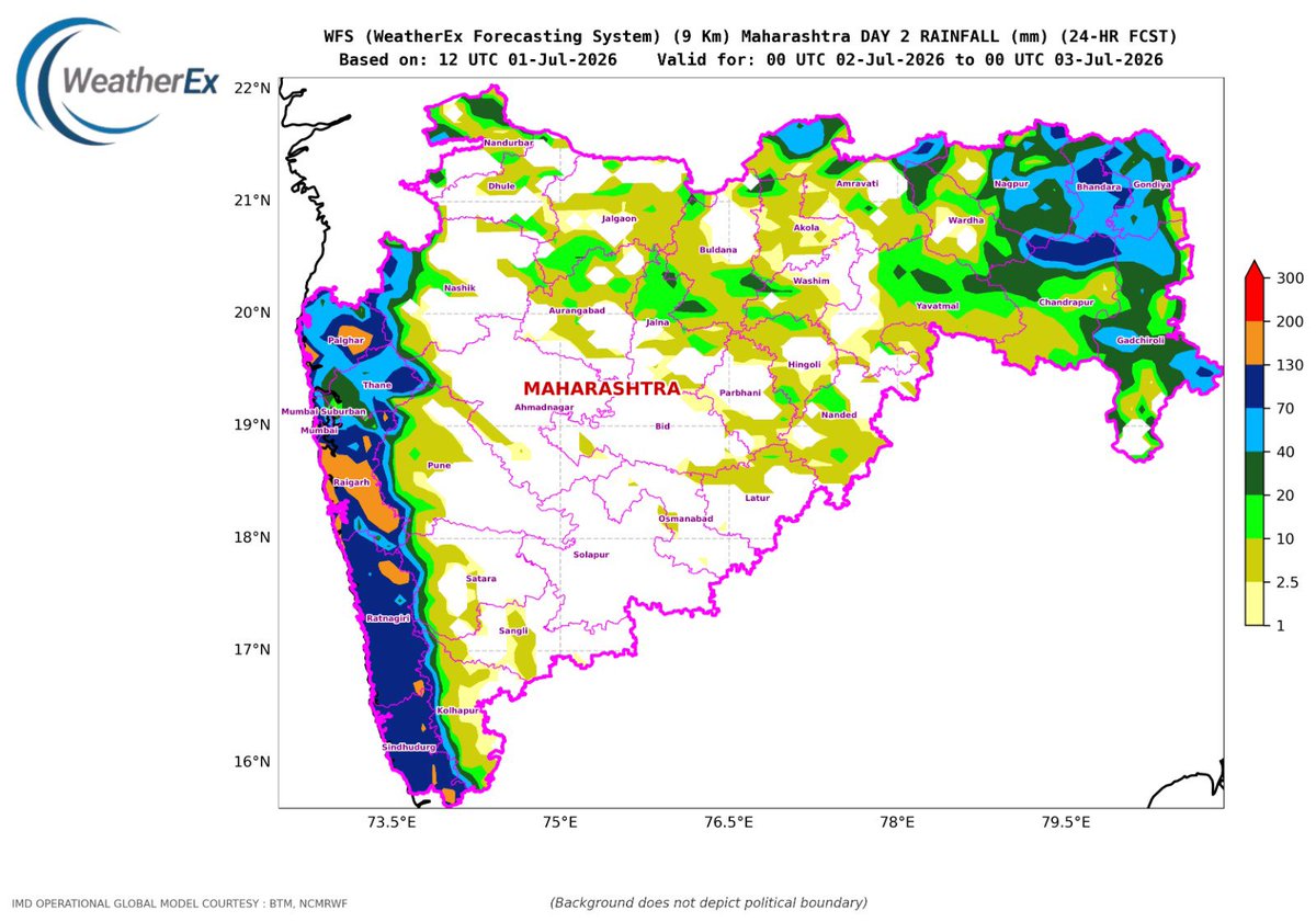
Maharashtra Rainfall Forecast | 2 July 2026
The 9 km WeatherEx Forecasting System indicates very heavy to extremely heavy rainfall along the Konkan coast and adjoining Western Ghats during the 24-hour period from 00 UTC 2 July to 00 UTC 3 July.
The highest rainfall is likely across Mumbai, Mumbai Suburban, Thane, Palghar, Raigad, Ratnagiri and Sindhudurg, with isolated intense spells capable of causing waterlogging, reduced visibility and local disruption.
Moderate to heavy rainfall is also expected over parts of Nashik, Pune, Satara and Kolhapur, particularly near the ghat sections.
Across Vidarbha, widespread moderate to heavy rainfall is indicated over Nagpur, Bhandara, Gondia, Chandrapur and Gadchiroli, with locally stronger pockets. Interior Marathwada and parts of central Maharashtra are likely to receive mostly light to moderate rainfall.
⚠️ Konkan, Mumbai Metropolitan Region and the ghat areas should remain on high alert for intense rainfall spells.
Forecast: WeatherEx Forecasting System — 9 km resolution
🌧️ WFS Rainfall Forecast | 2 July 2026
The WeatherEx Forecasting System (WFS), running at 9 km resolution, indicates an active monsoon pattern across large parts of India during the next 24 hours.
🔴 Heavy to very heavy rainfall is likely along the Konkan–Goa coast, coastal Karnataka, Kerala and the Western Ghats.
⚠️ Intense rainfall pockets are also indicated over Odisha, Chhattisgarh, eastern Madhya Pradesh, parts of Maharashtra, West Bengal and Northeast India.
🌧️ Widespread rainfall is expected across the Himalayan foothills, Uttarakhand, Himachal Pradesh and adjoining northern plains, while comparatively lower rainfall may persist over parts of interior southern India and western Rajasthan.
Residents in vulnerable areas should remain alert for waterlogging, localised flooding, reduced visibility and travel disruptions.
Model: WeatherEx Forecasting System (WFS)
Resolution: 9 km
Valid: 2 July 2026
🌐 https://t.co/SBXmEtWYKX
#WeatherEx #WFS #Monsoon2026 #RainfallForecast #IndiaWeather #HeavyRain #Konkan #WesternGhats
We forecasted correctly for yesterday and the forecast seems correct also for today looking the heavy rain happening now in Powai. A snapshot from https://t.co/KNrsSVSnjN, you may start following the webportal, though we are updating it and adding a few new experimental services.
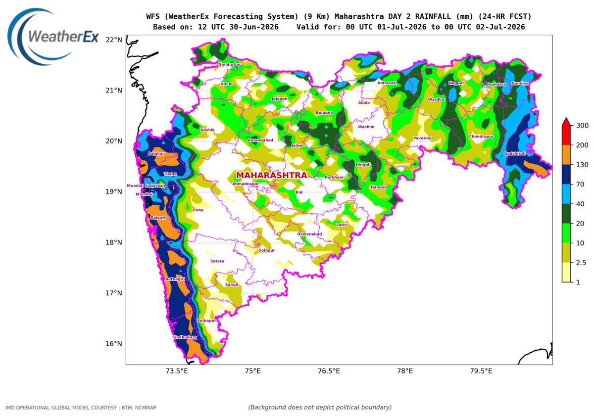
🌧️ Maharashtra Rainfall Update | WFS Forecast
The WeatherEx Forecasting System indicates widespread rainfall across Maharashtra during the 24-hour period ending 2 July morning.
The heaviest rainfall is likely along the Konkan coast and adjoining Western Ghats, particularly over Mumbai, Thane, Palghar, Raigad, Ratnagiri and Sindhudurg, where isolated very heavy to extremely heavy spells are possible.
Moderate to heavy rainfall is also expected across parts of Nashik, Pune, Kolhapur and eastern Vidarbha, including Nagpur, Bhandara, Gondia, Chandrapur and Gadchiroli. Interior parts of Marathwada and western Maharashtra may receive comparatively lighter, scattered rainfall.
⚠️ Localised waterlogging, reduced visibility and disruption to road traffic remain possible across the Konkan belt and Mumbai Metropolitan Region.
@Visheshkar Suryawanshi SEOC
Mumbai and many parts of India are heading into an active rainfall phase 🔴🌧️
Over the coming week, widespread rain is likely across the Konkan coast, Central India, the Himalayan region, and Northeast India 🔴⛈️ with a few heavy to very heavy spells at isolated places.
For Mumbai, rainfall is expected to increase from 1 July, with the most active phase between 2–5 July 🔴🌧️ Localised waterlogging, reduced visibility, and traffic disruption may occur during intense spells. 🚨
Stay updated with https://t.co/7sQpBUIlZb 📍
https://t.co/b7GaZsEZD3
A Shift in the Monsoon Pattern 🌧️
While the season has begun quietly, our latest analysis on the https://t.co/SBXmEtWYKX platform indicates a significant change on the horizon.
A low-pressure circulation is currently forming in the Bay of Bengal. As this system develops, it is projected to draw in substantial moisture, driving heavy, torrential rainfall across the Indian landmass starting July 2nd.
Stay ahead of the changing conditions and track real-time meteorological developments with us.
#WeatherEx #Monsoon #Meteorology #WeatherForecast #DataAnalytics #IndiaWeather
🌧️ Monsoon flow strengthening over India!
The 700 hPa wind forecast for 28–30 June shows strong southwesterly moisture transport from the Arabian Sea toward the west coast, favouring enhanced rainfall over Kerala, coastal Karnataka, Goa, Konkan–Mumbai and adjoining Maharashtra. Moisture convergence may also support active rainfall across parts of central and eastern India.
#Monsoon2026 #MumbaiRains #WeatherEx #IndiaWeather
🌧️ Heavy rain spell likely from 29 June across Mumbai, Konkan and parts of Maharashtra.
Rainfall may intensify through 30 June–1 July, with extremely heavy rain possible on 2 July. A tentative model-based Red Warning is indicated for 2 July, subject to further updates.
⚠️ Waterlogging, traffic disruption, rough seas and landslide risk may increase. Stay alert and follow official advisories.
🔗 https://t.co/SBXmEtWYKX
#MumbaiRains #MaharashtraWeather #KonkanRains #WeatherEx
🌧️ Monsoon flow strengthening over India!
The 700 hPa wind forecast for 28–30 June shows strong southwesterly moisture transport from the Arabian Sea toward the west coast, favouring enhanced rainfall over Kerala, coastal Karnataka, Goa, Konkan–Mumbai and adjoining Maharashtra. Moisture convergence may also support active rainfall across parts of central and eastern India.
#Monsoon2026 #MumbaiRains #WeatherEx #IndiaWeather
🌧️ Mumbai Rainfall Outlook | WFS 3 km Forecast
The WeatherEx Forecasting System indicates mostly light, scattered rainfall across Mumbai on 28 June, with a few moderate spells possible over southern and eastern suburbs.
Rainfall activity is expected to increase noticeably on 29 June, with moderate to locally heavy spells likely across parts of Mumbai, Thane and Navi Mumbai. Eastern and northeastern areas may receive the higher rainfall totals.
Residents should remain prepared for short periods of intense rain, localised waterlogging and slower traffic during stronger spells.
Forecast period: 28–30 June 2026
Model: WFS 3 km | https://t.co/7sQpBUIlZb
Forecasts will be updated with each new model cycle.