Meteorologist, @NEWSCENTERMaine | Former Chief Meteorologist, @kiii3news | Certified by the National Weather Association | Avid Golfer | @UTSA & @msstate Alum
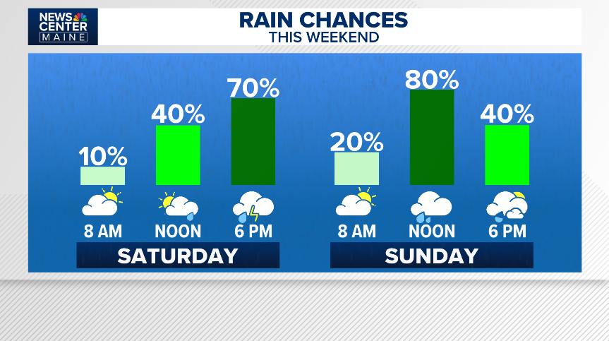
SAT/SUN mornings are looking like the driest timeframes this wknd. SAT will feature hit/miss showers or storms into the aftn as a pre-frontal trough moves in. SUN aftn looks like a more widespread, steady rain. This, in response to wrap around moisture pooling along a cold front
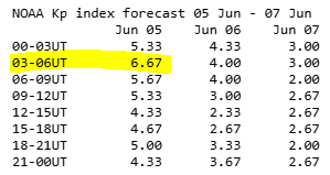
June 5, 6p | The CME eventually did reach Earth between 11a and 2p today. It looks like the geomagnetic storm is now waning, meaning there won't be a chance of seeing the Northern Lights in Maine tonight. Had this come in 12 hours earlier, we probably would have seen some colors.
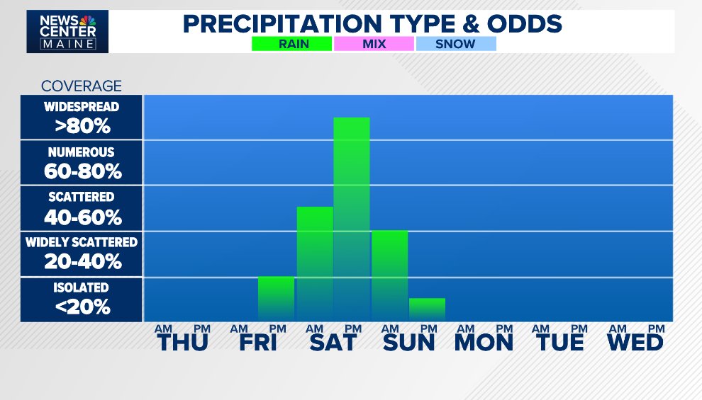
TLDR; it's likely there will be scattered thunderstorm activity that develops west of Maine, but as it moves into Maine, storms should weaken as they run into cooler air.
There's a 'marginal' risk for a severe thunderstorm in Western and Southern Maine, Saturday afternoon evening. This is a low-end risk and coverage of any stronger activity will be isolated. Being in the marginal risk zone does not guarantee you get a severe storm.
An interesting wrinkle in Saturdays storm chance will be the influence of onshore flow. Into Maine, it'll likely suppress the storm risk and lower temperatures into the 60s or 50s at the coast. Far Western Maine and New Hampshire will be in the 70s; a lot more juice west of Maine
The K index didn’t come up much last night. So, either the CME from the Sun on Wednesday missed Earth, or it was far weaker than anticipated. Either way, the Northern Lights chance last night was a dud.
JUNE 4, 11P | The K index is still at low levels. That means the CME that the sun yielded yesterday has not yet reached Earth's atmosphere. This number needs to come up to around a 7 if Maine is to have a shot at seeing the Northern Lights.
After a CME today, the K-Index is forecast to rise to around a 7 THU night, which could mean that the Northern Lights may be visible in Maine. It'll be worth a look. Even if it's not visible with the naked eye, using the night mode camera on phone can sometimes capture the colors
As of writing, rain looks to move into Northern Maine Saturday morning, spreading south, into the rest of the state in the afternoon and night. Rain exits from north to south Sunday morning with a drier afternoon to follow. Highs Sunday stay in the middle to upper 60s.
A disturbance out west will find the opening between two regions of high pressure and move into Maine this weekend, delivering a chance for rain and a cool down.
Middle to lower 40s overnight. Temps come up into the middle and upper 60s and 70s Tuesday afternoon. Look for a blend of sun and clouds with a small shot at an isolated afternoon shower. NW breeze at 5-10 mph.
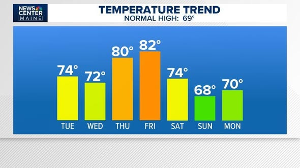
The first (work) week of June looks stunning. 70s TUE & WED, 80s THU and FFRI. This all comes with fair weather. Into the weekend, we're expecting a disturbance & cold front which brings in a rain chance and drops temps back down closer to seasonal average for early June.
June 1 marks the first day of Meteorological Summer (and the Atlantic Hurricane Season). June tends to deliver increasing amounts of weather pleasantries to Maine. Average highs by the end of the month are in the upper 70s. Looking forward to it.
The moon will be full at 4:45a, Sunday, so tonight will be the night when it’s the most full in the night sky.
Because it’s the 2nd full moon within a calendar month, it’s dubbed a ‘blue moon’; one of three variations of a blue moon 🌝🌚
Rain exits Maine late AM/early PM, Saturday. But it stays mostly cloudy, blustery, & cool in the afternoon.
Sunday starts nice, but with pop up showers or storms over the western half of the state Sunday. Temperatures cool into the 50s; milder east.
Going 6.1 on the 'nometer
The afternoon will bring a round of hit and miss showers through the western half of Maine; an isolated rumble of thunder is also possible. Temperatures will cool back into the 50s with the rain around in the afternoon; milder in Eastern/Northern Maine
Sunday morning will likely be the nicest timeframe of the upcoming weekend. Sunny to partly cloudy with temperatures warming into the 50s and middle and lower 60s (and less wind).