Did you know that @AmericaView state members create #geospatial tools that anyone can use? Check out KansasView's Sentinel Green Report for agriculture applications. https://t.co/KBLeZ98DIh
Listen to all of the remote sensing adventures of @AmericaView's very own, Dr. Robert Washington-Allen on this week's episode of our Spatial Signals podcast. https://t.co/PxCRxfXhnt
Planning to attend @GeoWeekExpo? The Super Saver deadline is Friday, December 19, and this is your final chance to secure the best rate and save more than $200 on registration. Register now, https://t.co/uMMFwg9H9I.
Tune in to this weeks Spatial Signals podcast episode to hear from geospatial extraordinaire, @josephkerski! This episode features, "I Was There From the Cretaceous to the Holocene" https://t.co/fIS3YTHkbY
Do you want to know what remote sensing has to do with salmon in Alaska? Tune into this week's episode of Spatial Signals to find out! https://t.co/fIS3YTHS1w
Thinking about attending @GeoWeekExpo? The 2026 conference program is now available. Check-out all the great things that are going to happen and get registered! https://t.co/7IYDVzNrzS
Save the date! #geoweek will be held February 16-18, 2026 in Denver, with the theme Harness The Power Of Geospatial. Register with code SAVE100 for a $100 conference discount or FREE expo admission ($200 value). https://t.co/pRh4jJMqaN
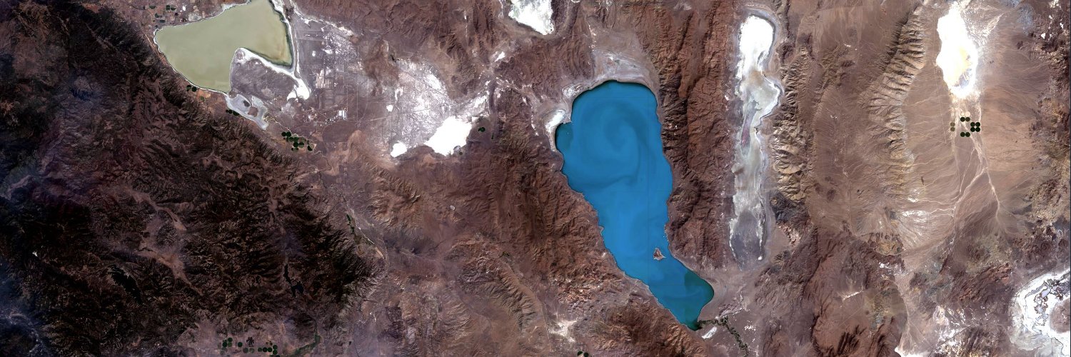
Today is Earth Observation Day! Download our 2025 poster, part of the #EarthScienceWeek teacher toolkit. There are great #Landsat images and teacher materials related to Earth's Energy Resources. https://t.co/lGNvZWd6nS
Tomorrow is Earth Observation Day, an education and outreach celebration of #Landsat. Tune into this week's Spatial Signals Podcast episode to hear all about how it began. https://t.co/fIS3YTHkbY
Tune in to this week's Spatial Signals Podcast episode to hear about what remote sensing has to do with being stuck in ice in the North Atlantic and polar bears! https://t.co/fIS3YTHkbY
Join VirginiaView in their upcoming training series about Agricultural Spray Drones. Learn about the legal landscape, operational best practices, and hands-on insights to support the use of agricultural spray drones. Free but registration is required https://t.co/gHoqfpN70p
It is Monday and that means the new Spatial Signals episode is out! This week, listen to Scott Powell from MontanaView and his story about The Bad News Bears Wildfire Fighting Team. https://t.co/QeLIFACd70
Introduction to GIS Programming: Book Release and Code Examples Walkthrough
YouTube Video: https://t.co/Dr6kZBM7sH
In this video, I provide a step-by-step guide on running the code examples from the book using Binder, Colab, and Docker.
You can install all Python packages used in the book with a single command using pip, pixi, or conda.
pip install pygis
mamba install -c conda-forge pygis
Get the book:
PDF: https://t.co/nJ7OxxC08o
Full-color print edition: https://t.co/E8gKdpyzmv
#geospatial #opensource #python #mapping
Listen to this week's episode of Spatial Signals and learn about the first digital global map from AmericaView's former Director, Bobbi Lenczowski. https://t.co/FdVgNkGRrm
@WyomingView recently visited with 3rd graders from Laramie, Wyoming and taught them about using satellite imagery to see the effects of floods, hurricanes, and tornadoes. Look what one of the students had to say about their visit.
Have you heard about the @AmericaView podcast, Spatial Signals? You should listen in and learn about the people and projects that make @AmericaView the great organization that it is! https://t.co/fIS3YTHkbY