On dévoile quelques secrets. 📖
Après 5 ans de veille techno, voici notre livre de recettes 🧑🍳 sur comment développer des cartes interactives pouvant traiter un important volume de données sur une interface conviviale et rapide.
https://t.co/jqCxxGxTrI
🚀 YOGRT 🍦
Tired of writing ogr2ogr scripts to load spatial raw data into PostGIS? Well we are too!
We are happy to launch and share YOGRT, our dbt-like tool for extracting and loading geospatial information to PostGIS : https://t.co/tXaJGS8wHn
#ogr2ogr#postgis#dbt#yogrt
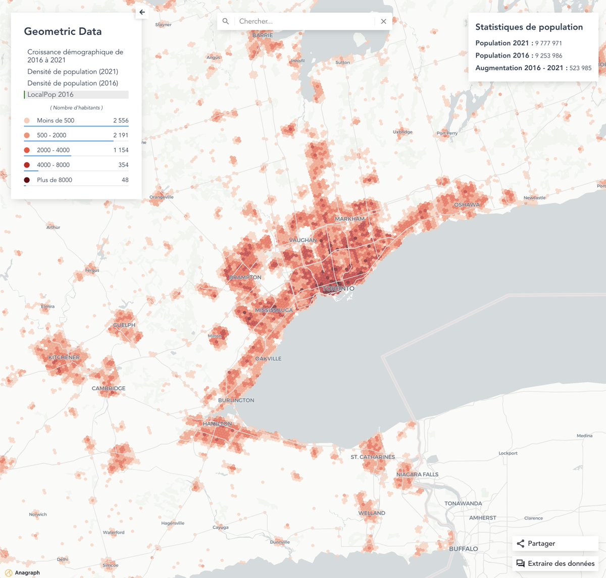
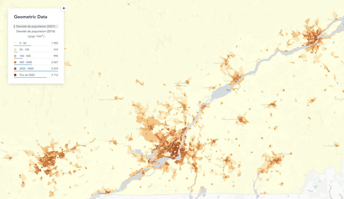
Voici "LocalPop", le premier jeu de données d'@AnagraphGeo représentant le nombre d'habitant sur une grille hexagonales, partout au Canada 🇨🇦
https://t.co/VgnIdusGJO
Les données du #RecensementDe2021 sont disponibles depuis ce matin sur @StatCan_fra
Les chiffres sur la population sont maintenant accessible via carte web : https://t.co/NlMyChvbU8
The style generation script is key for any team working in an iterative design process with multiple parties.
In this article, we demonstrate how our team uses Node.js to automate the generation of a JSON style file from a QGIS XML style file.
https://t.co/kJB9RvWmdA
Our team works hard to keep abreast of the latest technological advances in geospatial in order to develop cutting-edge solutions.
Catch a glimpse of our expertise and follow our weekly digest, where you can find all of our best finds!
https://t.co/We2hCGmqj5
🛍 Trouver la localisation optimale pour l'implantation d'un commerce est la clé du succès pour tout commerce au détail.
Dans cet article, découvrez comment choisir son pignon sur rue grâce à l’intelligence géographique! https://t.co/XYgO7Wlquf
En plus d’impressionner par sa qualité d’image et sa rapidité de chargement, la modélisation 3D est un puissant outil d’optimisation :
🚧 Des opérations d'une ville
📡 D’entretien des réseaux de télécommunication
🚘De la conduite autonome
Collab w/@Jakarto3D
🎯 We focus on continually discovering our customers evolving needs and rapidly validating our deployed solutions.
Have a compelling project? Let's talk! 👉 https://t.co/lcIIefj7wz
How we create beautiful and clean products that solve specific business needs :
🏋️♀️ Continually raise the bar of the customer experience of geospatial products.
Visionnez la présentation #GISDAY 2020 de notre plus récent talent, Zachary Déziel, sur ce qu’il appelle « La légende du buffer ».
https://t.co/tNyx27pfji
Dans cette première publication d’une série de trois, nous vous montrons comment les données géospatiales peuvent être la solution à certains problèmes.
Ici, nous expliquons comment l’analyse de données géospatiales peut mitiger les risques en entreprises.
#riskmanagement
We are recruiting!
Looking for a person ready to take up challenges and who wish to put their passion and technical skills to develop geospatial solutions. Join our dynamic and friendly team!
💼 https://t.co/BbjPaHhNPN
#webmapping#locationintelligence#datamapping
Nous recrutons!
Anagraph souhaite accueillir une personne prête à relever des défis et qui saura mettre à contribution son expertise en solutions géospatiales. Viens joindre une équipe dynamique et sympathique!
💼 https://t.co/BbjPaHhNPN
#webmapping#webgis#postgis#dataviz
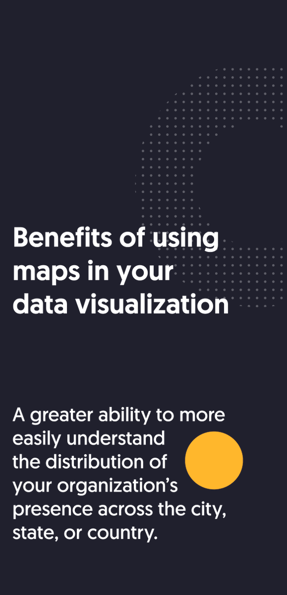
Combining geospatial information with data over time creates a greater scope of understanding of different aspects of your business (#supplychain, #riskmanagement, @salesopportunities, etc.)
Here are some benefits of using #maps in your #dataviz .
Good read which offers some starting points for people interested in visually communicating census data, and to identify where things may be headed in this space over the next couple of years.
#dataviz#CensusDay#mapping#geography#webmapping
https://t.co/9j4Ai7IKNn