La temperatura mínima del 2026 se encuentra por encima de la normal de temperatura máxima para junio (+1.0°C) y muy por encima de la normal de temperatura mínima (+5.4°C).
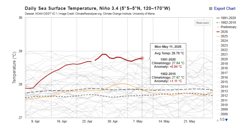
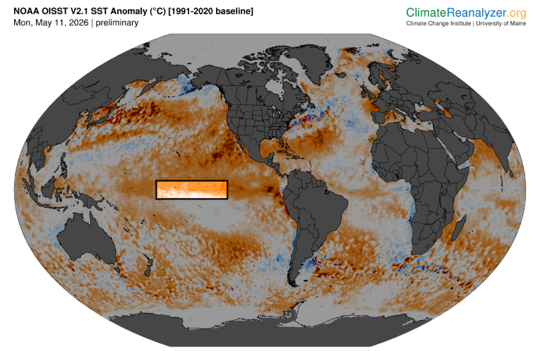
Nunca antes por estas fechas y con datos modernos se han visto temperaturas tan altas de la superficie del agua en la región NIÑO3.4 de Pacífico ecuatorial central.
#ElNiño
Figuras de Climate Reanalyzer
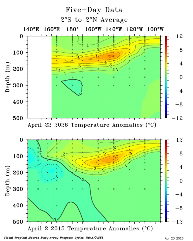
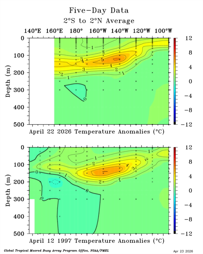
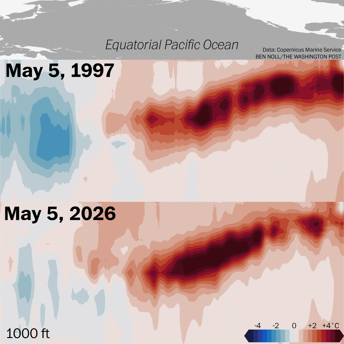
Meet the El Niño twins: 2026 and 1997.
They aren't identical, but they sure have a lot of similarities.
Exceptionally warm waters were closer to the Pacific Ocean surface at this time in 1997, but 2026 is breaking records for warmth at depth.
Which twin will win? Stay tuned!
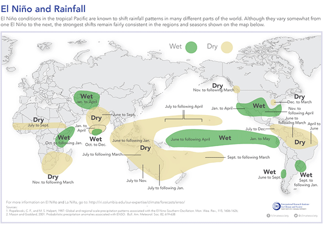
The effects of El Nino are widespread across the globe, not necessarily just those attached to the Pacific Ocean.
Five global regions hit hard by a Super El Nino: https://t.co/CRo3JRbl6V
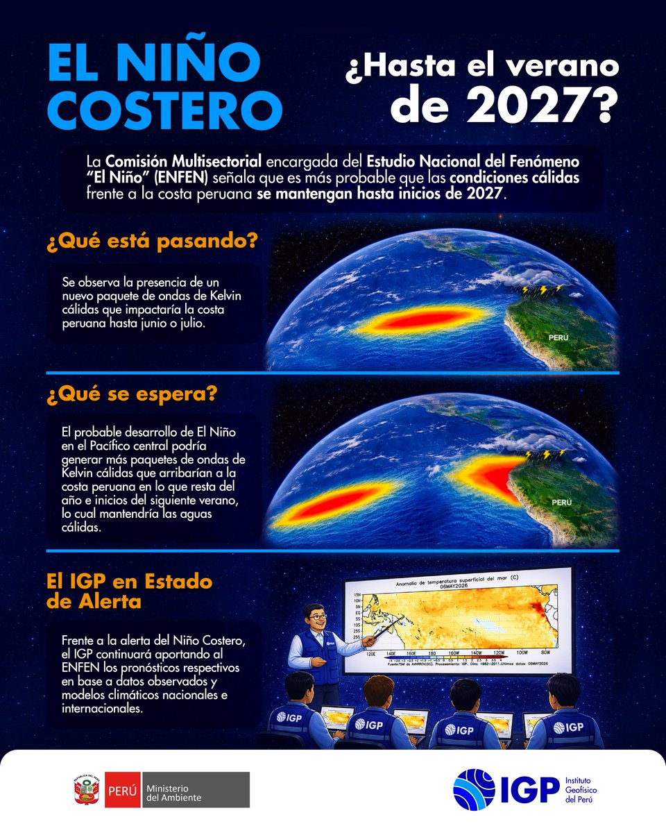
🌊 ¿Se extiende El Niño Costero? El ENFEN advierte sobre condiciones cálidas hasta el verano de 2027. Te explicamos por qué y qué está pasando en nuestro mar.🌦️
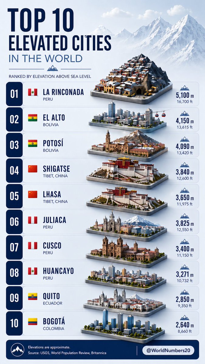
🏔️ Mind-blowing! The Top 10 Highest Cities in the World (by elevation above sea level)
1️⃣ La Rinconada, Peru – 5,100 m
2️⃣ El Alto, Bolivia – 4,150 m
...down
to Bogotá, Colombia at 2,640 m
These places are literally living on top of the world! 🏔️🌍
Which one surprises you the most? Ever visited any high-altitude cities? Drop it below 👇
El Niño: When the Ocean Rewrites the World
Watching the ocean means watching our shared future.
https://t.co/VAkegxXHzc
El Niño begins as a shift in winds and warm water across the tropical Pacific. But its impact does not stay in the ocean. It can reshape rainfall, intensify heat, disrupt fisheries, affect food prices, strain water resources, and deepen risks for vulnerable communities.
What happens in one part of the Pacific can reach dinner tables, farms, cities, and economies around the world. If a strong El Niño develops later this year, it will be more than a climate event. It will be a reminder that our planet is connected by a delicate balance.
The downwelling Kelvin Wave over the Central Pacific is now slightly stronger than previous events (1997 and 2023) were at the same approximate longitude. There's also yet another downwelling wave yet to propagate east from the WPAC (driven by the last westerly wind burst). With weak trade winds forecast across the Pacific the next two weeks, there will be nothing to attenuate these Kelvin Waves, so they will continue to propagate east and lead to rapid warming of the Central and East Pacific as we progress into #ElNiño.
Actualización sobre El Niño y proyección. (Hilo)
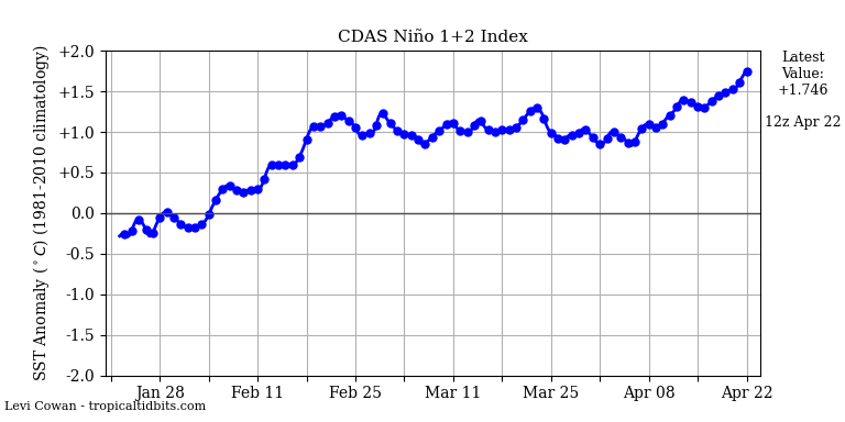
Hoy 22 de abril todo el Pacífico se encuentra en condiciones propias de El Niño (regiones 1+2, 3, 3.4 y 4 sobre 0.5°C). El mayor calentamiento se concentra en el lado oriental, es decir costa de Ecuador y Perú, que superan los 1,7°C.
🧵
🦈😯 🌊 Un hallazgo desde las profundidades del mar peruano
El tiburón linterna de ojos pequeños, Etmopterus litvinovi, fue registrado por primera vez en el Perú a más de 1400 metros de profundidad.
El Niño ya se acerca y viene con fuerza.
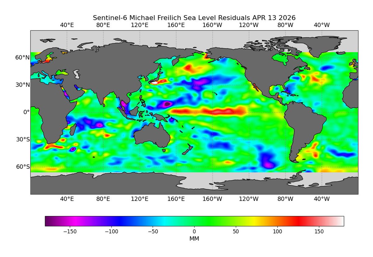
Miren esa zona roja moviéndose en el Pacífico, indica con claridad que el nivel del mar ha aumentado, esto por el calentamiento del océano.
Y si aún tienes dudas de lo que viene, todas las regiones del Pacífico están en umbrales de El Niño, además la atmósfera ya se está acoplando, por lo tanto en mayo es probable tener un Niño consolidado.
Es solo cuestión de tiempo para experimentar impactos en el clima de nuestro país.
La perturbación del nivel del mar por efecto de la Kelvin es de 20 cm. Se prevé su arribo a la costa oeste de Sudamérica (Ecuador, Perú) para mediados de mayo. Influyendo también en la profundización de la termoclina y aumento de la temperatura superficial del mar.
Buen día,
Así estamos esta mañana en cuanto a anomalías la temperatura del mar. Se estima que una onda kelvin cálida haga contacto con la costa en unos 8-10 días. Aún resta por observar variabilidad del APS y grado de salinidad de aguas para prever reacción de borde costero.