#ONStorm#ONwx It’s a warm one out there today! 🥵
⚠️ Caution: This map uses orange and red colours to indicate hot temperatures. We apologize in advance to anyone who may be startled by the existence of a red map. Please remain calm, take a deep breath, and remember that the sun will rise again tomorrow. 🤗
Many areas across Southern Ontario are seeing temperatures in the high 20s and even low 30s. When you factor in the humidex, it’s feeling more like the mid to upper 30s, making for a very muggy day.
If you’re spending time outdoors, be sure to drink plenty of water, take frequent breaks in the shade or air conditioning, and never leave children or pets unattended in vehicles. Heat-related illnesses can develop quickly, especially during the hottest part of the afternoon.
We are also monitoring the potential for pop-up thunderstorms fueled by this hot and humid air. We’re already seeing some development around Hamilton, where the environment could support the formation of funnel clouds.
While these types of funnel clouds rarely make contact with the ground, in very rare cases they can touch down and become brief landspout tornadoes. We’ll be watching closely for any reports throughout the afternoon.
There is also the potential for a line of thunderstorms to move into Deep Southwestern Ontario later this evening and overnight. There remains some uncertainty regarding how strong the line will be by the time it reaches the border, and it could weaken significantly, similar to what happened with last night’s storms.
We’re keeping a close eye on it!
How are you enjoying the heat today? Hopefully you’re finding a way to stay cool! ☀️
- Brennen
Thunderstorm Outlook for tomorrow PM 👇
Risk of severe storms across parts of SW/ Eastern #Ontario
Zone A- 90km/hr wind gusts and 2-3cm hail
Zone B- 90km/hr wind gusts, 2cm hail, 30-50mm of rain
#OnWX#ONStorm
Summer isn’t cancelled, but for much of central and eastern Canada, it may struggle to take hold. Here is your official #SummerForecast ☀️
https://t.co/w35FJrJH1X
#ONStorm#ONwx On this day in 2022, a historic derecho steamrolled across Southern Ontario and into Quebec, across the most densely populated corridor of Canada. There were nine EF2 strength downbursts and four tornadoes associated with the derecho, including an EF2 tornado that touched down in Uxbridge with estimated wind speeds of 195km/h.
Sadly, sixteen people lost their lives and $1.257 billion worth of damage was caused over the 1000km path of destruction. Our condolences go out to the friends and family of those who were lost.
What do you remember from this day?
- Alannah
Map courtesy of the Northern Tornadoes Project
#ONStorm#ONwx 💨🌪️ Tornado Tuesday Could Bring Damaging Storms to Southern Ontario With Strong Severe Threat
📅 Tuesday, May 19, 2026
⤵️ VIEW THE FULL FORECAST:
https://t.co/GxVaV80fhs
- Brennen
———
Thank you to our sponsor, Xolar: Energy For The Future ☀️⚡️
Xolar Inc is a Canadian-owned solar installation company installing solar and battery backup for homeowners and businesses across Canada.
Right now, Xolar Inc is making an exclusive offer only to members of our Instant Weather community to get an additional $2500 off any solar and battery backup installation, on top of the $10,000 in Provincial rebates available for solar + battery.
If you would like to claim this special $2500 Instant Weather offer, as well as the $10,000 provincial rebate, request a solar + battery quote with Xolar Inc at the link below!
LEARN MORE: https://t.co/EmJovKlbFh
———
#ONStorm#ONwx ⚠️ SEVERE THUNDERSTORM WATCH ISSUED FOR PARTS OF SOUTHERN ONTARIO ⚠️
Environment Canada has issued a Severe Thunderstorm Watch for a large portion of Southern Ontario ahead of a potentially active severe weather day this afternoon and evening.
Forecasters say conditions are favourable for thunderstorms capable of producing:
🌬️ Wind gusts of 90 to 110 km/h
🧊 Hail up to ping pong ball size
🌪️ An isolated tornado also cannot be ruled out
At this point, damaging wind gusts appear to be the primary concern with any storms that develop later today.
Our team is currently working on a detailed forecast that will break down the timing, storm mode, highest risk areas and tornado potential in much more detail. That forecast will be posted very soon.
We will also be LIVE STREAMING throughout the afternoon and evening with minute-by-minute storm tracking and coverage as storms begin to develop. If today turns active, Instant Weather will be the place to be for in-depth severe weather coverage across Ontario.
Now is a good time to review your severe weather safety plan and make sure you have a way to receive warnings later today.
Download our FREE app to get the latest Environment Canada alerts along with our custom notifications delivered instantly to your phone: https://t.co/2M0dQUUuFx
- Brennen
———
Thank you to our sponsor, Xolar: Energy For The Future ☀️⚡️
Xolar Inc is a Canadian-owned solar installation company installing solar and battery backup for homeowners and businesses across Canada.
Right now, Xolar Inc is making an exclusive offer only to members of our Instant Weather community to get an additional $2500 off any solar and battery backup installation, on top of the $10,000 in Provincial rebates available for solar + battery.
If you would like to claim this special $2500 Instant Weather offer, as well as the $10,000 provincial rebate, request a solar + battery quote with Xolar Inc at the link below!
LEARN MORE: https://t.co/EmJovKlbFh
———
#ONStorm#ONwx 🌪️ Tornado Tuesday: Severe Thunderstorm Risk Across Parts of Ontario
After today’s storm risk, attention will quickly turn toward another potentially active severe weather day on Tuesday across Southern Ontario.
A hot and unstable atmosphere may develop across the province tomorrow afternoon and evening, creating the potential for severe thunderstorms capable of producing damaging wind gusts, large hail and even isolated tornadoes.
At this point, confidence remains lower regarding exactly where storms will form, and whether they form at all, but the environment itself looks quite favourable for severe weather if storms can develop.
Current indications suggest the greatest risk may target parts of Southwestern Ontario, the Golden Horseshoe and regions around Lake Simcoe during the afternoon and evening hours.
This map is PRELIMINARY and will likely be adjusted as new data comes in overnight. We’ll have a finalized outlook map posted tomorrow morning once confidence improves in storm timing and development areas.
We’ll also be LIVE on YouTube throughout Tuesday’s severe weather risk with real-time storm tracking, warning updates and live coverage if storms begin to develop. 🌪️
Stay tuned!
- Brennen
———
Thank you to our sponsor, Horizon Tree Company: We Go Out on a Limb So You Don’t Have To! 🌲
Horizon Tree Company Inc. is a family-owned and operated professional tree care company providing safe, reliable, and high-quality services. With certified expertise and a strong commitment to safety and integrity, we help protect properties and support healthy communities. We proudly serve communities throughout Simcoe County, Muskoka, and the Parry Sound - Nipissing district.
Get an exclusive 10% discount on any tree service for being an Instant Weather community member.
LEARN MORE: https://t.co/6gg7n7z0Sf
———
Hottest day of the year today with temperatures around 30c particularly just inland from Lake Ontario. Few showers possible this PM. Repeat Tues with temperatures near 30c but very humid Tues PM with thunderstorms (severe likely). Cold front Tues PM & *much cooler* Wed AM.
#ONStorm#ONwx ❗️🌪️ Multi-Day Severe Storm and Tornado Risk Targets Southern Ontario Alongside Summer-Like Heat
📅 Monday, May 18 - Tuesday, May 19, 2026
⤵️ VIEW THE FULL FORECAST:
https://t.co/Svec0IgwE5
- Brennen
———
Thank you to our sponsor, Horizon Tree Company: We Go Out on a Limb So You Don’t Have To! 🌲
Horizon Tree Company Inc. is a family-owned and operated professional tree care company providing safe, reliable, and high-quality services. With certified expertise and a strong commitment to safety and integrity, we help protect properties and support healthy communities. We proudly serve communities throughout Simcoe County, Muskoka, and the Parry Sound - Nipissing district.
Get an exclusive 10% discount on any tree service for being an Instant Weather community member.
LEARN MORE: https://t.co/6gg7n7zyHN
———
#onstorm ⚠️ BREAKING 🌪️: Environment Canada forecasting potential for Tornado Tuesday in the “C” zone of this map in the afternoon/evening. For those getting the “D” zone, no tornado risk as per Environment Canada. “C” has a risk of an isolated tornado, 110km/h wind gusts, 2-4cm hail, & 20-40mm of rain.
More details & our custom forecast ASAP.
- Adam (Sun, May 17, 2026)
P.S. We’re submitting our new app for approval! Should be available by late tonight or sometime tomorrow depending on how fast they approve it! Woohoo!!!
#ONStorm#ONwx ⚠️⛈️ Severe thunderstorms could return to parts of Ontario on Victoria Day.
As temperatures surge toward 30°C, increasing instability may spark isolated severe storms with risks including damaging wind gusts, hail and torrential rain.
We’re also tracking the potential for a more widespread storm risk on Tuesday as a cold front moves through.
See our full thunderstorm risk map and detailed forecast: https://t.co/RF6UZmlAcg
- Brennen
———
Thank you to our sponsor, Xolar: Energy For The Future ☀️⚡️
Xolar Inc is a Canadian-owned solar installation company installing solar and battery backup for homeowners and businesses across Canada.
Right now, Xolar Inc is making an exclusive offer only to members of our Instant Weather community to get an additional $2500 off any solar and battery backup installation, on top of the $10,000 in Provincial rebates available for solar + battery.
If you would like to claim this special $2500 Instant Weather offer, as well as the $10,000 provincial rebate, request a solar + battery quote with Xolar Inc at the link below!
LEARN MORE: https://t.co/EmJovKlbFh
———
#ONStorm#ONwx 🥵 Victoria Day to Bring Early Tease of Summer to Southern Ontario With 30°C Heat and Severe Storm Risk on Monday
📅 Monday, May 18, 2026
⤵️ VIEW THE FULL FORECAST:
https://t.co/RF6UZmlAcg
- Brennen
———
Thank you to our sponsor, Xolar: Energy For The Future ☀️⚡️
Xolar Inc is a Canadian-owned solar installation company installing solar and battery backup for homeowners and businesses across Canada.
Right now, Xolar Inc is making an exclusive offer only to members of our Instant Weather community to get an additional $2500 off any solar and battery backup installation, on top of the $10,000 in Provincial rebates available for solar + battery.
If you would like to claim this special $2500 Instant Weather offer, as well as the $10,000 provincial rebate, request a solar + battery quote with Xolar Inc at the link below!
LEARN MORE: https://t.co/EmJovKlbFh
———
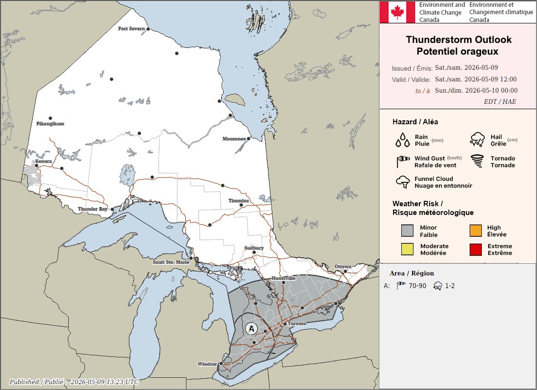
Environment Canada is forecasting 70-90km/h wind gusts and 1-2cm hail today (Sat, May 9, 2026) in the "A" region, which could include London, Windsor, Kitchener/Waterloo and surrounding communities. The rest of the grey region highlighted, which includes Niagara, GTHA, parts of Southwestern, Central and Eastern Ontario is a minor risk for thunderstorms.
We'll be keeping a close eye on things as some of the models have looked interesting for the potential for brief rotation. However, the main risks are certainly damaging wind gusts, hail, torrential rain and, of course, lightning.
More details ASAP.
- Adam #onstorm #ontario
#ONStorm#ONwx 🔔 Heads up! 🔔
There is a scheduled test of the Alert Ready system on Thursday, May 7, 2026, and it will take place at 1:55 PM ET in Ontario.
This test was originally scheduled for Wednesday at 12:55 PM, but has since been rescheduled to Thursday at 1:55 PM.
A test alert will be sent out to most smartphones, TV and radio stations across the province at that time.
IMPORTANT: The usual emergency alert tone will accompany the test alert. If you don’t want to be disrupted, be sure to turn off your phone before 1:55 PM. Keep in mind that the tone may still sound once your phone is turned back on.
Individuals in vulnerable situations, including those experiencing domestic abuse who may rely on hidden phones, could be unexpectedly exposed by the loud alert tone. If you or someone you know could be affected, be sure to plan ahead to keep devices powered off during that time.
Our system is operated independently from Alert Ready, so you won’t receive a test alert from our app or text message service.
- Brennen