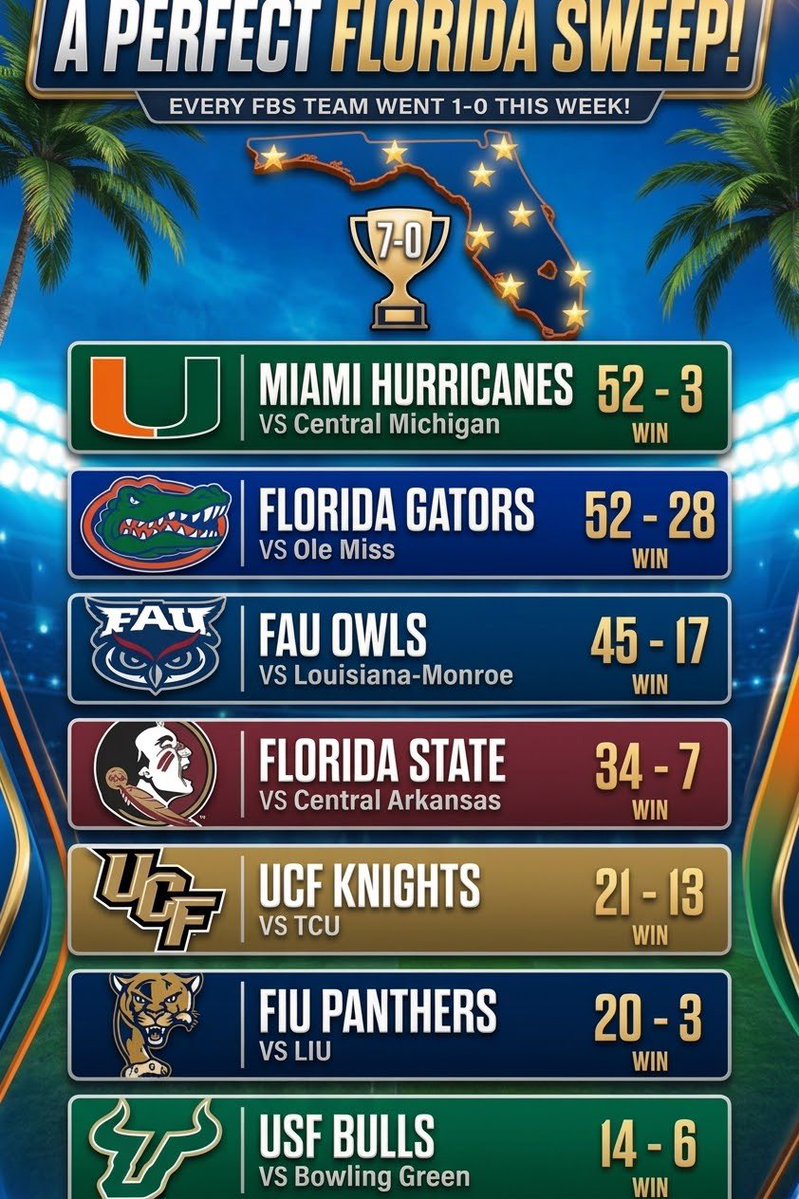
A perfect 7-0 sweep across the map! Every single FBS team in Florida took care of business and brought home a W
Miami vs C Michigan 52-3
UF vs Ole Miss 52-28
FAU vs ULM 45-17
FSU vs C Arkansas 34-7
UCF vs TCU 21-13
FIU vs LIU 20-3
USF vs BGSU 14-6
Can we do it again next week?
Perfect day for the Sunshine State
Miami won
Florida won
FSU won
UCF won
South Florida won
FIU won
FAU won
Today joins Oct. 5, 2013 as the only times that the state's seven FBS teams went 7-0 on the same day.
Insane new video of the NOAA Hurricane Hunters navigating through the 180 MPH eyewall of Hurricane Polo yesterday before reaching the massive Stadium Effect of the eye.
These are some of the bravest and most skilled pilots in the entire world.
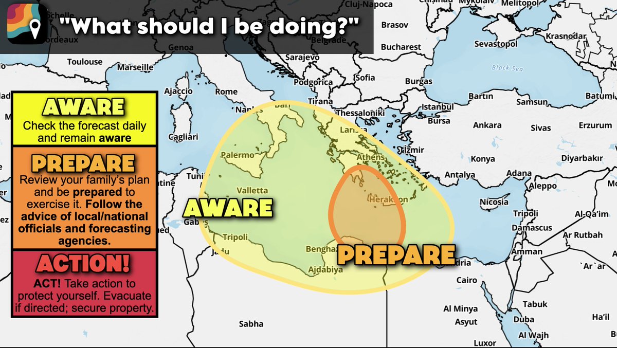
An extremely rare MEDICANE, or "Mediterranean hurricane", could form between Tuesday, September 15 and Thursday, September 17. Confidence is low to medium, but conditions could encourage tropical or subtropical development.
If you live in Sicily, along the Gulf of Taranto, Greece, northern Libya or northwest Egypt, we're recommending you be AWARE. If you live in the Ionian Islands or near Darnah, consider preparing for possible disruptions.
Some weather models indicate the potential for a low pressure system with some tropical characteristics to form southeast of Italy over the Mediterranean. There's a 30 to 40 percent chance this system evolves into a medicane, reminiscent of a tropical storm or borderline low-end hurricane.
It's too early to forecast specific impacts, though medicanes can harbor tropical storm-force winds (or, on rare occasions, hurricane conditions). Flooding is possible too if/where the medicane moves inland.
Medicanes are not technically hurricanes, despite the similar nomenclature; after all, “medicane” is a portmanteau of “Mediterranean” and “hurricane.” Despite this, they can deliver hurricane-strength impacts and harbor some tropical characteristics.
A true tropical cyclone generally requires water temperatures of 79 degrees F (26.1ºC) to form. Medicanes, on the other hand, have formed over water temperatures as cool as 57 degrees F (13.9ºC).
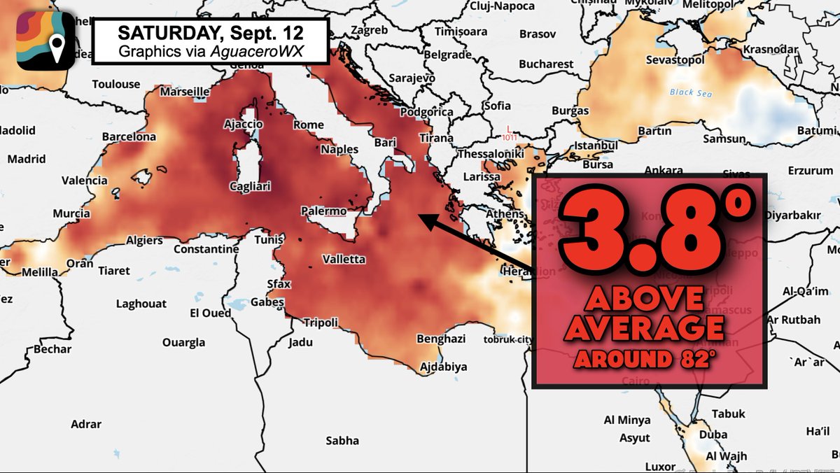
In this case, however, the eastern Mediterranean is running several degrees above average. Water temperatures are near 82 degrees F (27.8 degrees C).
A lobe of vorticity, or spin, will be present in the lower atmosphere at the tail end of a cold front. A few thunderstorms may blossom coincident with that pocket of spin – especially as an upper-air disturbance swings overhead. Frigid air aloft over warm, subtropical waters will promote the formation of tall thunderstorms, and perhaps a system with some tropical characteristics.
What separates a tropical from a non-tropical disturbance? Where they get their energy.
True hurricanes and tropical cyclones are warm-core systems. They derive their energy exclusively from warm waters. Near-surface air, heated by warm seas below, rises into colder air aloft.
Non-tropical "cold-core" systems derive derive energy from "baroclinicty," or the clashing of air masses of different densities. Nor'easters, winter storms and most other weather systems are "cold core" systems.
Most medicanes typically *start* as cold-core systems, but then gradually transition toward a warm-core system. Under the right circumstances, a cold-core pocket of vorticity (spin) can encounter warmer waters over the Mediterranean. In the absence of harsh winds tearing the fledgling area of rotation apart, it can be invigorated from the bottom up.
In this case, any medicane would probably have both tropical and non-tropical characteristics, and be considered "subtropical".
Medicanes are fairly infrequent, with only a dozen forming between 1982 and 2003. Because the Mediterranean is a small basin bounded by landmasses, medicanes have a limited amount of time over water and, subsequently, energy they can feed off.
Medicanes tend to be small systems — at most 200 miles across — and have much shorter life spans than their big-ocean cousins. While some medicanes have been able to stick around for a few days, like a 90-hour beast in September 1983, they tend to show tropical characteristics for only hours rather than days. Most of the time, these hybrid storms are more akin to a nor’easter that we see in winter along the East Coast.
The strongest on record was Medicane Ianos, which impacted Greece September 17-18, 2020. It briefly became the equivalent of a tiny Category 2 hurricane with winds of 95 mph.
Interestingly, Libya has seen medicanes before. In September 2023, Cyclone Daniel became the deadliest medicane on record. Despite having maximum winds of only 55 mph, it killed nearly 6,000 people by moving into Libya and causing the collapse of the Derna and Mansour dams. That brought castastrophic flooding along the Wadi Derna river, inundating large sections of the city of Derna.
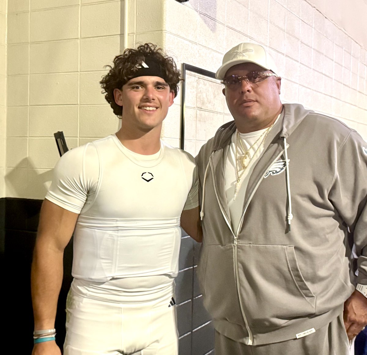
Penn State quarterback Rocco Becht and Eagles security chief Big Dom DiSandro met up outside the PSU locker room at Lincoln Financial Field on Saturday after the Nittany Lions defeated Temple, 27-9.
This map highlights the 43% of Earth's surface where snow has fallen — or may have fallen — at some point since 1940.
It may surprise you!
One particularly fascinating snow pixel: Papua New Guinea's 14,793-foot Mount Wilhelm, just 5° south of the equator.
PEAK OF HURRICANE SEASON IS TODAY🌀
We've made it to the halfway point with (so far) a lot of good news. On Saturday, we will set a new record for the latest we've gone without an Atlantic hurricane in the satellite era. Last time we had this little tropical activity at the halfway point was 85 years ago in 1941.
While the powerful El Nino and rounds of Saharan Dust have largely helped us out, don't let your guard down just yet. We still have late September and October to get through before we pop the champagne. Hope for the best, always be prepared just in case. I'll let you know when we're eventually in the clear with updates 24/7. Thanks everyone!
- Matt Devitt Weather
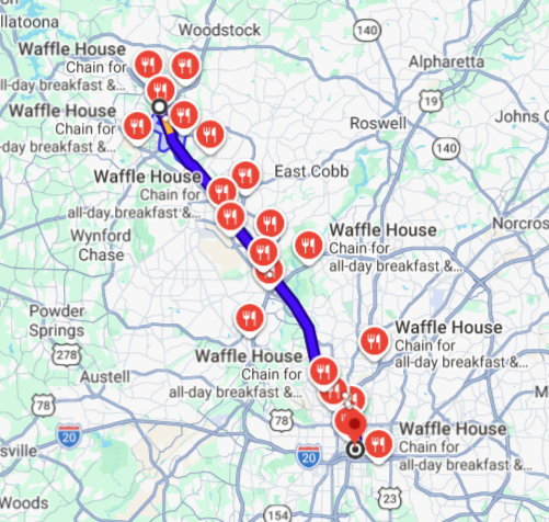
Georgia State plays at Kennesaw State this weekend. About 23 miles separate the schools. There are approximately 20 Waffle House locations between the two schools.
“What you got to see today is what I get to see when it’s 5:15 in the morning and the first guy in the facility catching on the JUGS (machine) is Koby Howard.”
Matt Campbell talked about the Penn State receiver after his breakout performance today.
Probably my favorite piece of video that I shot of @CoachMC_PSU on Saturday .. here's his reaction to missed FG at end of 1st half to preserve shutout, tosses the headset and sprints off, great hustle from @GregKincaidPSU and @BTrippTweets to get the halftime interview!