Light showers still moving through the metro this morning, mainly to the north. We should see gradual clearing throughout the day, with breezy winds at times in the afternoon.
Light to moderate showers will continue to move from west to east over the next 1-2 hours. Expect strong southwest winds to continue into the afternoon hours as the cold front moves through the area, keeping highs about 10° cooler than yesterday.
The AZ Department of Environmental Quality has issued a High Pollution Advisory for the Rillito area near Marana, Wednesday. Strong and gusty winds is forecast to generate widespread blowing dust that may pose a health risk to vulnerable individuals.
While winds are expected to be "lighter" than yesterday, the KGUN Skycam is certainly showing a different story. Current wind gusts at the airport are between 25-30 mph.
Our morning showers will taper off for a bit, then return later this afternoon. Expect more light showers and possibly a few thunderstorms, mainly from Tucson north, lingering into the overnight hours.
Last day of 2025 Fun Fact: The low in Tucson this morning was 58°. This beats the old record of 51° set back in 2016. This will likely stand as the forecast temperature at midnight is 60°.
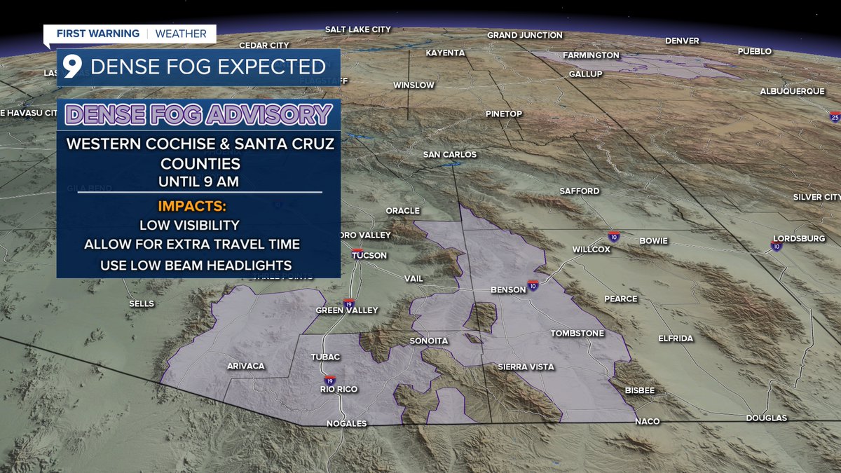
A Dense Advisory Fog Advisory is in effect for portions of southeast Arizona until 9 AM. Allow a little extra time for your morning commute if you're in these areas.
In case you missed it, here's a look at a few 24-hour rain totals as of 4 AM this morning. Showers could continue through mid to late morning, then clearing through this afternoon.
Light showers still coming down here on the eastside, at the KGUN 9 Studios. Expect this to linger into mid to late-morning, then clearing throughout the day.
A lovely view of the showers passing through Tucson from Tumamoc Hill. Although its a welcome site, please be aware of continued flooding as the run-off will last long after the rain ends. Please be safe folks! Turn around, Don't drown!