We are the Bay of Plenty Civil Defence Emergency Management Group representing all local councils and emergency managers in the protection of people and propery
There are now updated Tsunami Evacuation Zone maps for our region. Aotearoa’s entire coastline is at risk to tsunami. One way you can help prepare for a tsunami event is by checking whether you live, work, or spend time in a tsunami evacuation zone. https://t.co/iy3akicjQC
⚠️All weather warnings and watches have been lifted for the Bay of Plenty. The region has experienced a bit of rain, so please continue to take care out there - especially if you're travelling around.
@MetService has lifted the Thunderstorm Watch for Eastern Bay of Plenty (including Rotorua) and northern Taupo.
It remains for all other areas of the region at this stage.
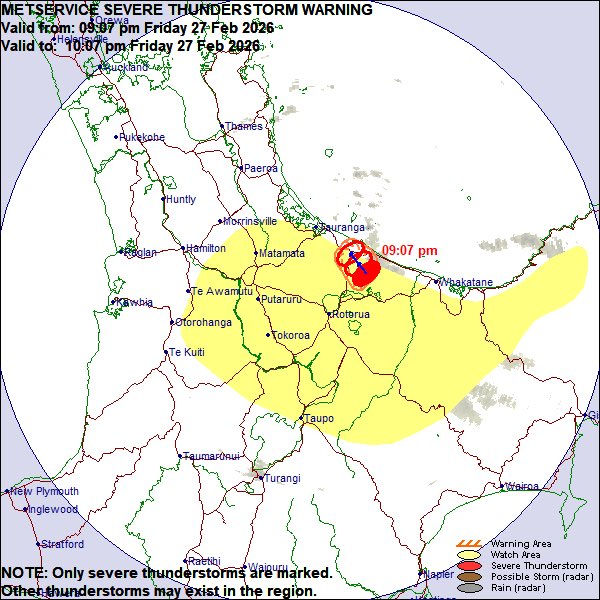
At 09:07 pm, MetService weather radar detected severe thunderstorms near ROTOEHU, PUKEHINA, PONGAKAWA VALLEY and PAENGAROA.
These severe thunderstorms are moving towards the northwest, and are expected to lie near TE PUKE, PUKEHINA, PONGAKAWA VALLEY and PAENGAROA
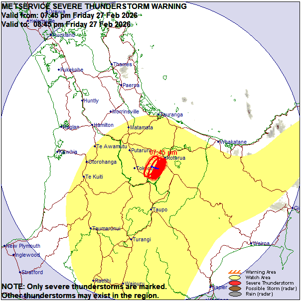
🔴⚠️⛈️At 07:45 pm, MetService weather radar detected severe thunderstorms near ROTORUA, WAIKITE VALLEY, WAIREKA, GUTHRIE and THE HILLS AND RANGES EAST OF TOKOROA. These severe thunderstorms are moving towards the westnorthwest, and are expected to lie near ROTORUA, MAMAKU, WAIKITE VALLEY, WAIREKA, GUTHRIE and THE HILLS AND RANGES EAST OF TOKOROA at 08:15 pm and near ROTORUA, MAMAKU, WAIREKA, GUTHRIE and THE HILLS AND RANGES EAST OF TOKOROA at 08:45 pm. These thunderstorms are expected to be accompanied by very heavy rain.
🔗Keep up with Thunderstorms warnings: https://t.co/kehfCfYMFf
⚠️ The isolated thunderstorm warning has been lifted.
The watch remains in place. Please refer to this post for details - we will keep you updated: https://t.co/eGWdbzHsqM
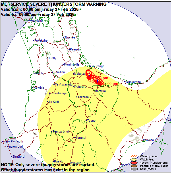
⚠️Update: At 05:00 pm, MetService weather radar detected severe thunderstorms near PYES PA, OROPI, OTANEWAINUKU, ROTORUA and OKERE FALLS. These severe thunderstorms are moving towards the north, and are expected to lie near THE SOUTHERN KAIMAI RANGES, PYES PA, OROPI, OTANEWAINUKU and OKERE FALLS at 05:30 pm and near TAURANGA, THE SOUTHERN KAIMAI RANGES, PYES PA, OROPI, OTANEWAINUKU and PAENGAROA at 06:00 pm. These thunderstorms are expected to be accompanied by very heavy rain.
Please be advised MetService has detected severe thunderstorms near Lake Rotoiti & Okere Falls.
These severe thunderstorms are moving towards the eastnortheast, and are expected to lie near this area and surrounds for approximately one hour.
@MetService
Heads up! @MetService have issued a Severe Thunderstorm Warning for Western Bay of Plenty and Tauranga from now until 7.15pm tonight. These thunderstorms are expected to be accompanied by torrential rain.
FYI if you live in areas around the south of Rotorua, you may receive an Emergency Mobile Alert.
This alert is designed for those in the Waikato area, however due to where cell towers are, there may be some cross over into the BOP region.
Please check if it applies to you.
Updated at 9am: A Severe Thunderstorm Warning has been issued for Opotiki / Whakatane. Severe thunderstorms moving towards the southsouthwest. Expected to lie near Waimana, Ruatoki North and Matahi. These thunderstorms are expected to be accompanied by torrential rain.
The weather in the Bay of Plenty continues to change at pace - there is now a Severe Thunderstorm Watch in place until 10pm tonight for the BOP (including Rotorua). Details: https://t.co/TxSjew6McD
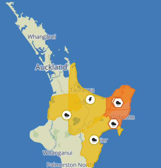
UPDATE as of 07:49am, Saturday 14 February. The Orange Heavy Rain Warning for the Bay of Plenty WEST of Opotiki, including Rotorua has been lifted.
The Orange Heavy Rain Warning for the Bay of Plenty EAST of Opotiki remains in place until 8:00pm this evening.
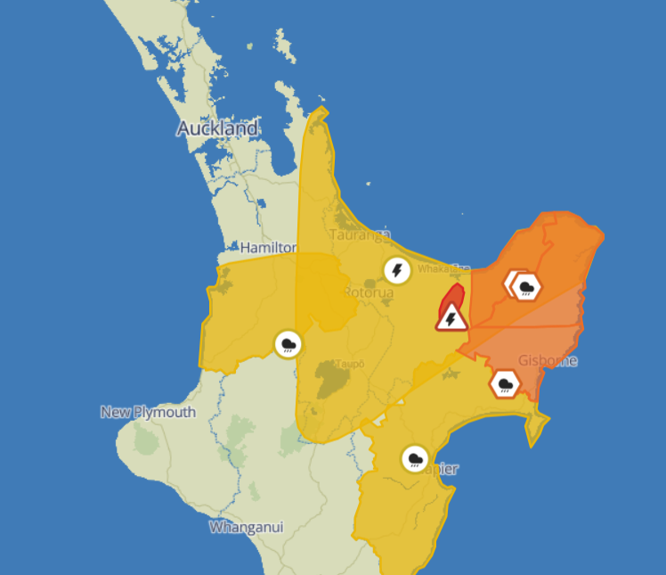
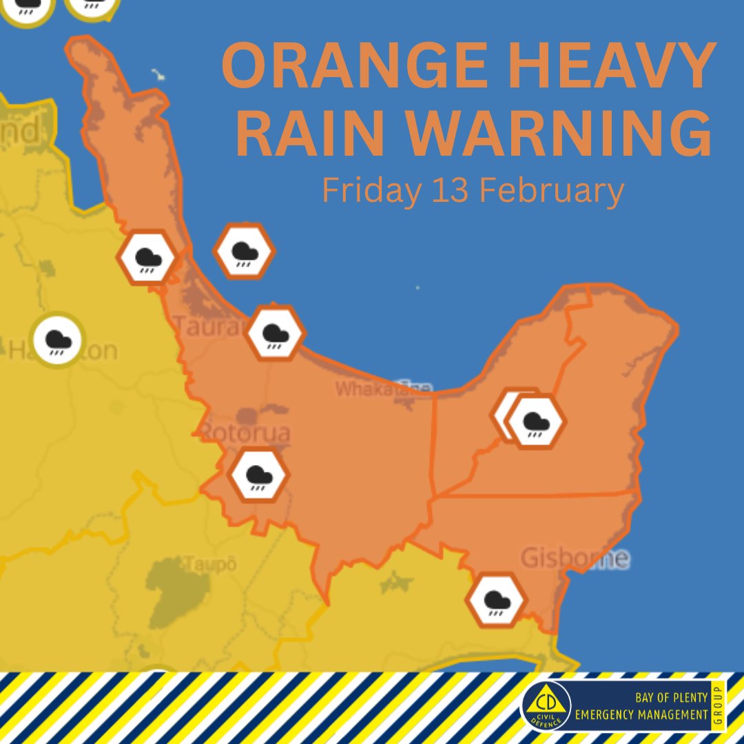
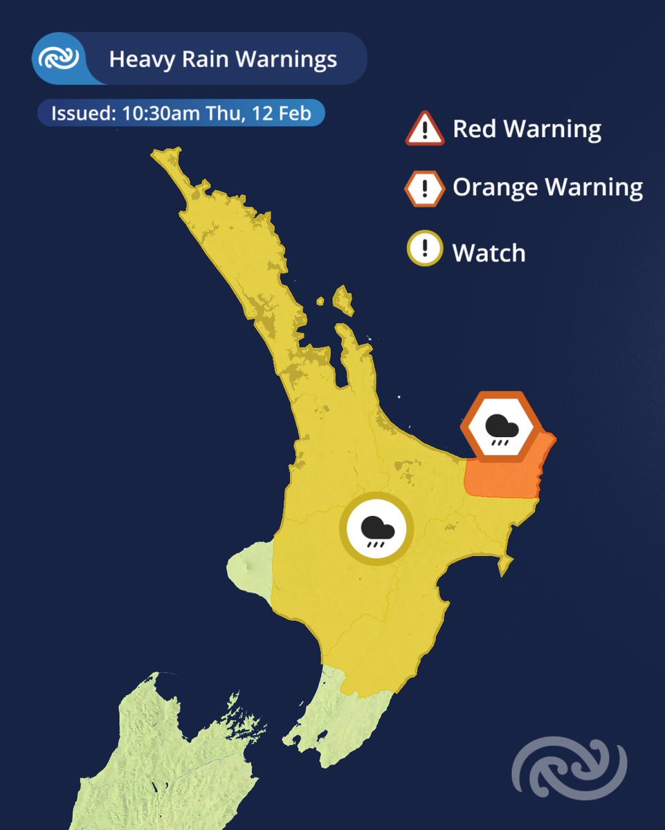
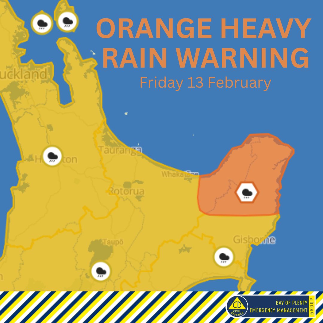
Morning all, @MetService have now issued Orange Heavy Rain Warnings for the entire Bay of Plenty Region. Please find the latest information on Metservice's website: https://t.co/U7AhHjdgE8
A wet Friday across the North Island.
Severe Weather Watches and Warnings issued for much of the North Island during Friday and into Saturday as thunderstorms and heavy rain move west to east across the country.
Heads up, @MetService have issued an Orange Heavy Rain Warning for Bay of Plenty east of Opotiki for a period of 14 hours, from 8:00pm Friday 13th to 10:00am Saturday 14th February. Visit Metservice for more information.
Severe Thunderstorm Warning
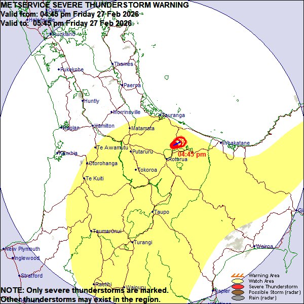
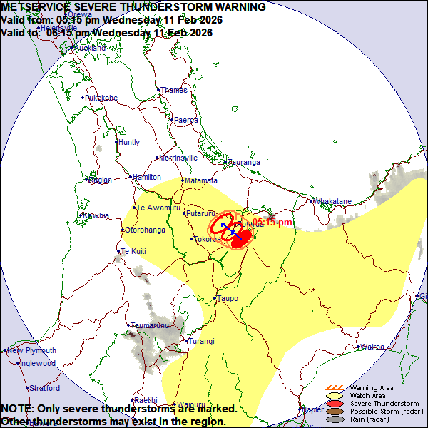
At 05:15 pm, MetService detected severe thunderstorms near ROTORUA, WAIOTAPU, WAIKITE VALLEY and LAKE TARAWERA, moving towards the northwest, and expected to be accompanied by torrential rain, hail and frequent lightning.
@BOPCivilDefence
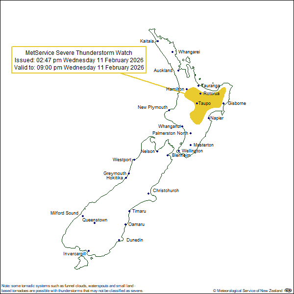
Severe thunderstorm watch - @MetService have issued a severe thunderstorm watch for inland parts of Bay of Plenty that will be in effect until 9pm tonight (11 February 2026).