This is the official X account for the Baron Critical Weather Institute. We lost access to our previous account, so look for new content from this account!
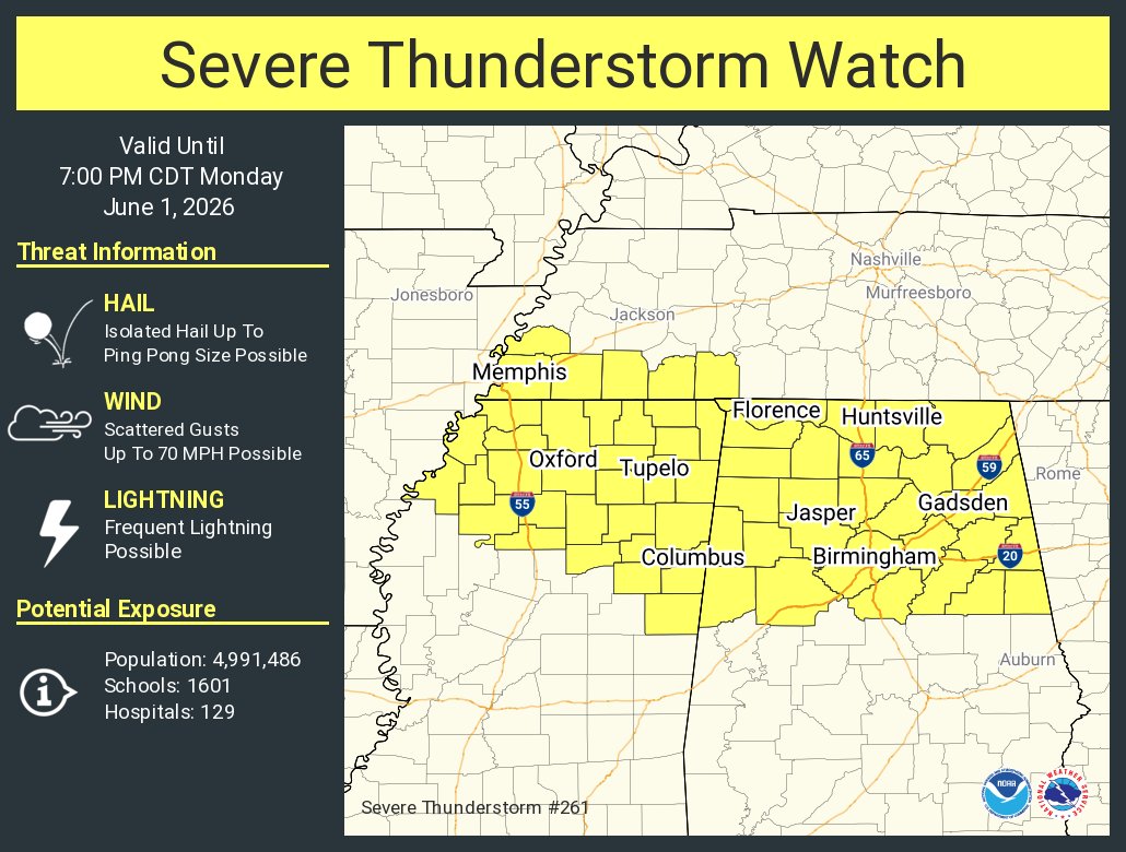
9:42 AM: There is an 80% of a severe weather watch for this outlined area. Please stay aware of the weather today and be ready to take action if a warning is issued. #HUNwx
2:40pm A Tornado Watch has been issued for Cullman, Morgan, Marshall and DeKalb Counties until 11pm. However for our counties, expecting the threat to end more around 7-8pm.
Stay weather aware & have more than 1 way to get warnings!
#HUNwx
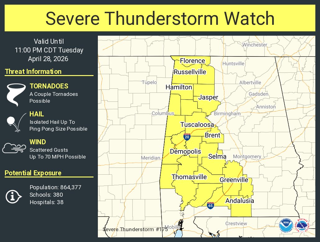
[3:55PM] Additional rain chances are forecast early to mid next week, with low chances of severe weather both Monday night and Tuesday night. Continue to stay updated with the latest forecast + have multiple ways to get warnings (including one that will wake you up!) #HUNwx
[520AM] Dry weather will persist through Thursday. However, shower & storm chances return on Friday, with a low risk of some storms becoming strong to severe. Shower & storm chances then continue through the upcoming weekend. Stay weather aware and check back for updates! #HUNwx
[4/21] There is a low risk of severe storms next Monday, April 27th throughout the Tennessee Valley. We have very low confidence in timing/threats this far out, however, we encourage everyone to stay up to date with the forecast through the weekend as we refine details. #HUNwx
[5:15PM] Showers with a low-medium chance of producing lightning are gradually moving eastward through the TN Valley. There is a low chance of some storms becoming strong, bringing a primary risk of gusty to damaging winds. #HUNwx
Check out this recent interview featuring our very own Bob Baron, who sat down with Clark Dunn, host of the Beyond Rockets podcast.
Beyond Rockets is a rising podcast based in Huntsville, Alabama
https://t.co/uQLqrvBB7Z
https://t.co/xndnRPISaz
[330PM] A Freeze Warning is in effect tonight thru 9AM Wednesday for all of N AL for temps in the mid 20s to lower 30s. Beyond this, a gradual warming trend is then forecast from the mid to late week. High temperatures by Friday are expected to rise back into the 70s! #HUNwx
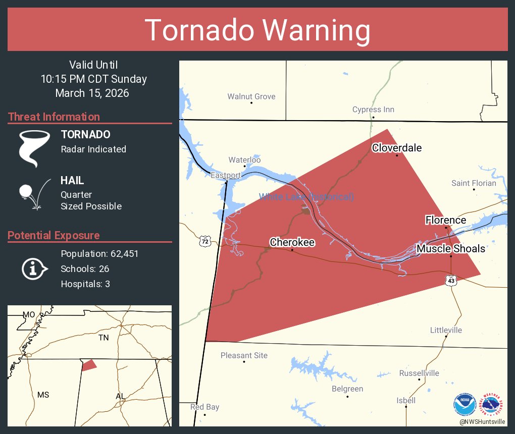
[905 PM] A line of strong to severe storms continues to move northeast across NE MS and will be entering NW AL over the next hour. Main concern is damaging wind gusts, hail, and a tornado. #HUNwx
[733 PM] A severe line of storms is moving eastward near Memphis with some storms popping up ahead of it in Northern MS. These should arrive to the AL/MS state line around 9pm this evening. Damaging winds and tornadoes are the main threat this evening with these storms #HUNwx
725 AM - Heads up! Strong to severe thunderstorms are forecast this evening, as a powerful cold front moves west to east across the TN Valley. Expect damaging wind gusts over 60 mph, and a few tornadoes. Please have more than one way to receive warnings this evening. #HUNwx
[3:06 PM] A line of strong to severe thunderstorms is forecast to move across the area Sunday night into Monday morning bringing the threat for widespread damaging winds and a few tornadoes. Begin prepping for overnight severe weather now by following these safety tips! #HUNwx


![NWSHuntsville's tweet photo. [3:55PM] Additional rain chances are forecast early to mid next week, with low chances of severe weather both Monday night and Tuesday night. Continue to stay updated with the latest forecast + have multiple ways to get warnings (including one that will wake you up!) #HUNwx https://t.co/6AMLa0UVpP](https://pbs.twimg.com/media/HGx21iWbcAAB4pg.jpg)
![NWSHuntsville's tweet photo. [3:55PM] Additional rain chances are forecast early to mid next week, with low chances of severe weather both Monday night and Tuesday night. Continue to stay updated with the latest forecast + have multiple ways to get warnings (including one that will wake you up!) #HUNwx https://t.co/6AMLa0UVpP](https://pbs.twimg.com/media/HGx2lyYawAA_wBv.jpg)
![NWSHuntsville's tweet photo. [520AM] Dry weather will persist through Thursday. However, shower & storm chances return on Friday, with a low risk of some storms becoming strong to severe. Shower & storm chances then continue through the upcoming weekend. Stay weather aware and check back for updates! #HUNwx https://t.co/vaCBonDPPd](https://pbs.twimg.com/media/HGgJbPGWkAAqOyI.jpg)
![NWSHuntsville's tweet photo. [520AM] Dry weather will persist through Thursday. However, shower & storm chances return on Friday, with a low risk of some storms becoming strong to severe. Shower & storm chances then continue through the upcoming weekend. Stay weather aware and check back for updates! #HUNwx https://t.co/vaCBonDPPd](https://pbs.twimg.com/media/HGgJabRWQAACwp_.jpg)
![NWSHuntsville's tweet photo. [330PM] A Freeze Warning is in effect tonight thru 9AM Wednesday for all of N AL for temps in the mid 20s to lower 30s. Beyond this, a gradual warming trend is then forecast from the mid to late week. High temperatures by Friday are expected to rise back into the 70s! #HUNwx https://t.co/522kO2BEKy](https://pbs.twimg.com/media/HDo7SFVW4AAMgb3.jpg)
![NWSHuntsville's tweet photo. [3:06 PM] A line of strong to severe thunderstorms is forecast to move across the area Sunday night into Monday morning bringing the threat for widespread damaging winds and a few tornadoes. Begin prepping for overnight severe weather now by following these safety tips! #HUNwx https://t.co/YMZopuN1Bo](https://pbs.twimg.com/media/HDUQYPRWIAAPBQ-.jpg)
![NWSHuntsville's tweet photo. [3:06 PM] A line of strong to severe thunderstorms is forecast to move across the area Sunday night into Monday morning bringing the threat for widespread damaging winds and a few tornadoes. Begin prepping for overnight severe weather now by following these safety tips! #HUNwx https://t.co/YMZopuN1Bo](https://pbs.twimg.com/media/HDUPxxbWoAALkPB.jpg)
![NWSHuntsville's tweet photo. [3:06 PM] A line of strong to severe thunderstorms is forecast to move across the area Sunday night into Monday morning bringing the threat for widespread damaging winds and a few tornadoes. Begin prepping for overnight severe weather now by following these safety tips! #HUNwx https://t.co/YMZopuN1Bo](https://pbs.twimg.com/media/HDUNwQUWEAAEw3W.jpg)





![NWSHuntsville's tweet photo. [3:55PM] Additional rain chances are forecast early to mid next week, with low chances of severe weather both Monday night and Tuesday night. Continue to stay updated with the latest forecast + have multiple ways to get warnings (including one that will wake you up!) #HUNwx https://t.co/6AMLa0UVpP](https://pbs.twimg.com/media/HGx26I7WUAAzB34.jpg)
![NWSHuntsville's tweet photo. [520AM] Dry weather will persist through Thursday. However, shower & storm chances return on Friday, with a low risk of some storms becoming strong to severe. Shower & storm chances then continue through the upcoming weekend. Stay weather aware and check back for updates! #HUNwx https://t.co/vaCBonDPPd](https://pbs.twimg.com/media/HGgJb5MXgAAKWql.jpg)
![NWSHuntsville's tweet photo. [4/21] There is a low risk of severe storms next Monday, April 27th throughout the Tennessee Valley. We have very low confidence in timing/threats this far out, however, we encourage everyone to stay up to date with the forecast through the weekend as we refine details. #HUNwx https://t.co/iFLVHz2Rxr](https://pbs.twimg.com/media/HGd44KGXIAAifwx.jpg)
![NWSHuntsville's tweet photo. [330PM] A Freeze Warning is in effect tonight thru 9AM Wednesday for all of N AL for temps in the mid 20s to lower 30s. Beyond this, a gradual warming trend is then forecast from the mid to late week. High temperatures by Friday are expected to rise back into the 70s! #HUNwx https://t.co/522kO2BEKy](https://pbs.twimg.com/media/HDo7SoVWcAEIx0m.jpg)




![NWSHuntsville's tweet photo. [3:06 PM] A line of strong to severe thunderstorms is forecast to move across the area Sunday night into Monday morning bringing the threat for widespread damaging winds and a few tornadoes. Begin prepping for overnight severe weather now by following these safety tips! #HUNwx https://t.co/YMZopuN1Bo](https://pbs.twimg.com/media/HDUQYQOXMAAxOwr.jpg)


