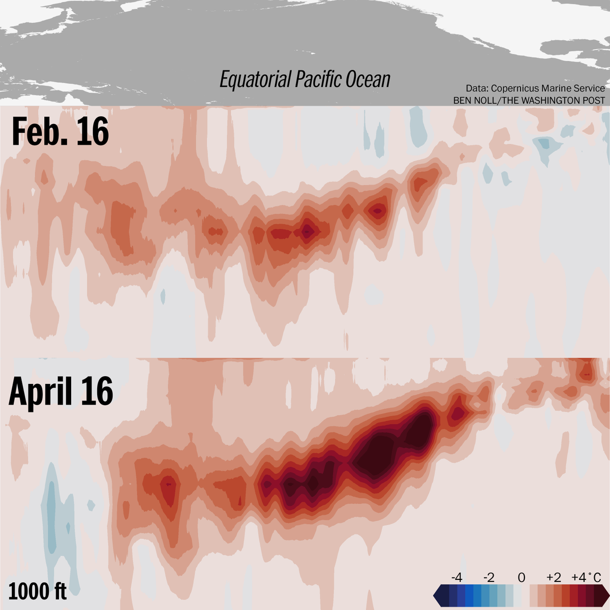
The impacts of the major westerly wind burst in the Pacific are finally becoming evident on plots of subsurface temperature anomalies, with considerable warming observed at about 160E. Might be comparable to or even stronger than the KW already progressing through the basin.
The development of El Niño has progressed rapidly.
Waters in the subsurface Pacific Ocean have now reached a gaudy 6˚C (11˚F) above average.
This warmth is rising toward the ocean's surface and aligns with projections of a super El Niño later this year.
I've added seasonal stats for the rest of the globe on https://t.co/zedO4ptg7M's homepage. It will be interesting to see how active some of the Pacific basins will get this year!
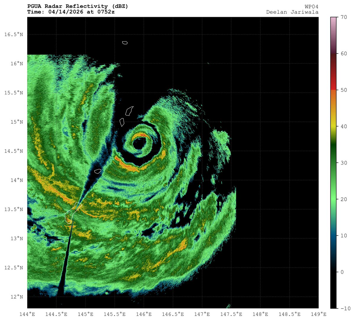
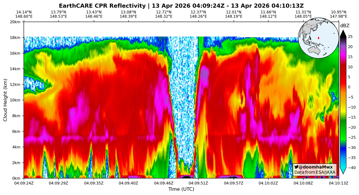
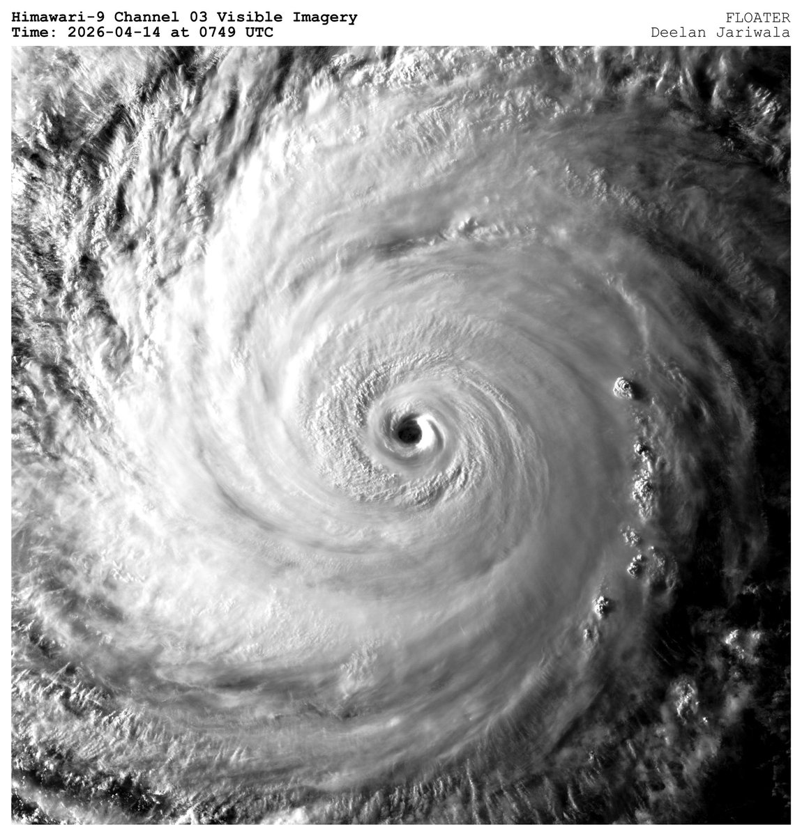
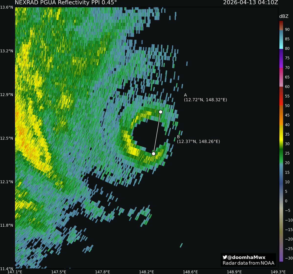
Earlier today, the Cloud Profiling Radar (CPR) aboard the @esa_earthcare satellite made a bullseye pass over Category 5 STY #Sinlaku, providing a vertical scan of the eye and >16km-high eyewall! Also cool to have NEXRAD data to go along with it.
It appears this is EarthCARE's first direct hit on the core of a category 5 storm since its launch in 2024!
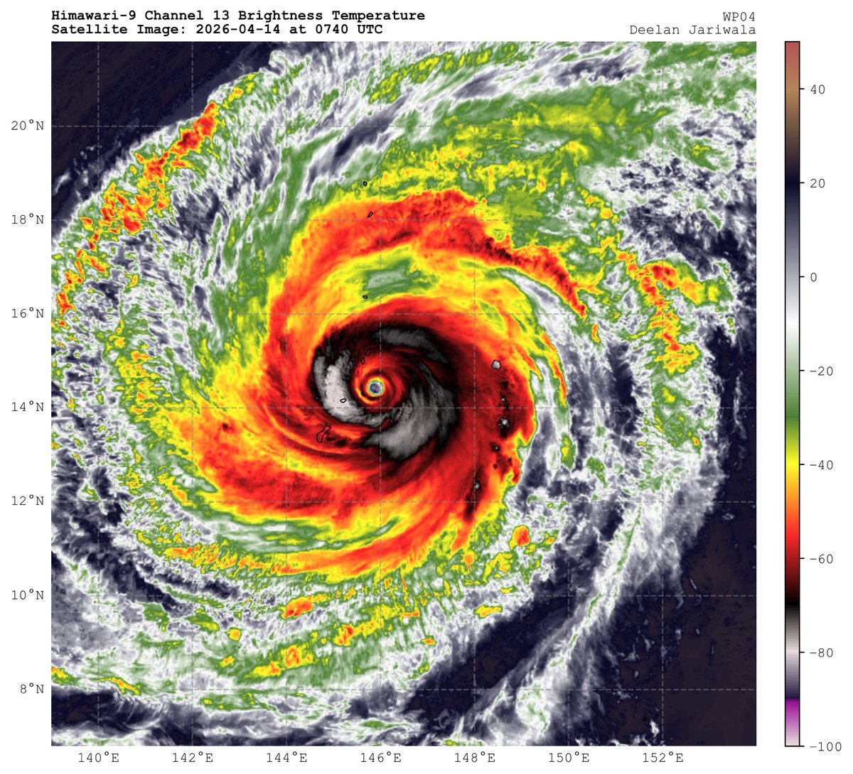
Tropical Storm #Sinlaku’s undergoing a very classic TC spin-up process.
In just about 18 hours, unabated and centralized moist convective processes have increased transport of momentum inward and amplified vorticity, intensifying the storm’s tangential + transverse circulation.
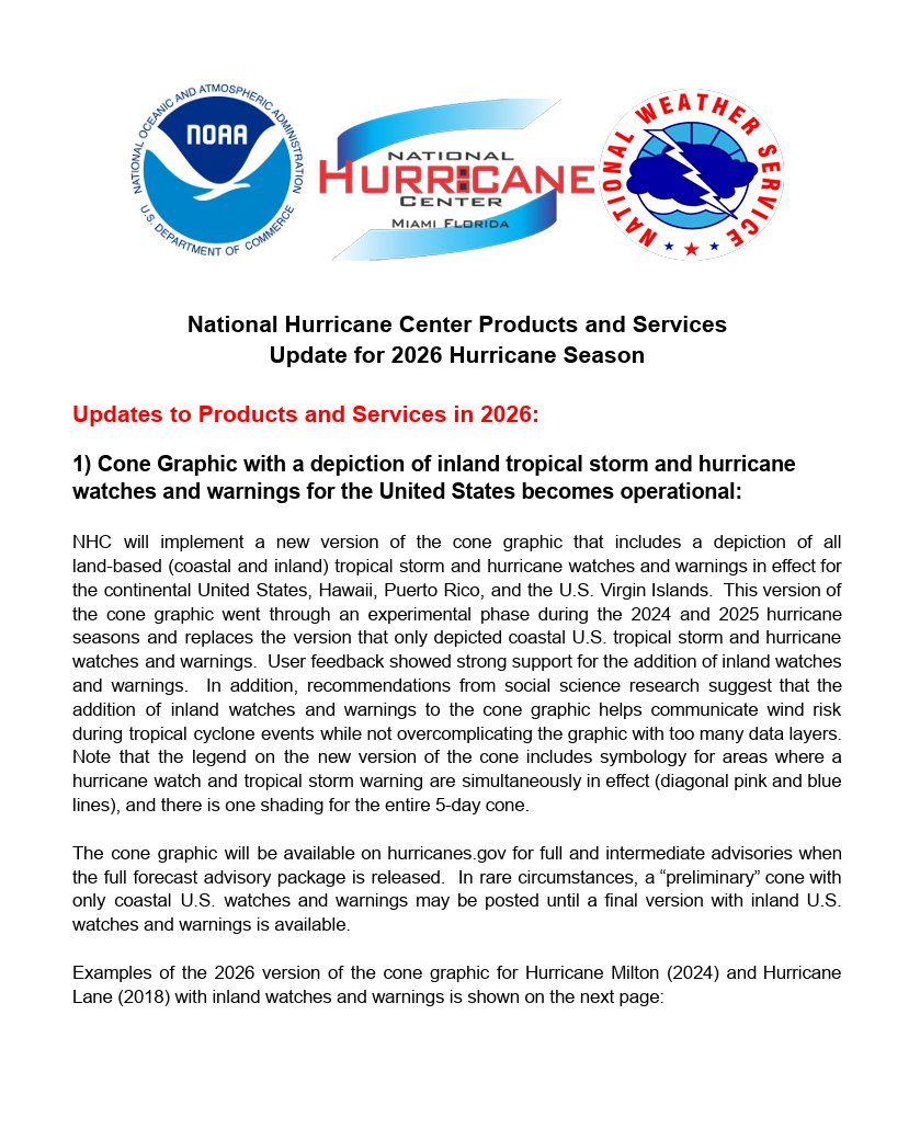
The National Hurricane Center is debuting an updated tropical cyclone forecast track cone for the 2026 hurricane, which includes U.S. inland watches and warnings and uses a single transparent shade for the entire 5-day forecast. In this video, NHC Warning Coordination Meteorologist Robbie Berg and Senior Hurricane Specialist John Cangialosi explain how the cone is created, and what it can and cannot tell you about a hurricane forecast.
For more information on the forecast track cone and other 2026 product updates, please visit https://t.co/o5yQhhDZNo
Video credits: Lisa Bucci, Cassandra Mora, and Maria Torres
NHC has announced its new products and services for the 2026 hurricane season: https://t.co/PyKbU3S0p3
Highlights include an operational forecast track cone with inland U.S. watches and warnings, new storm surge products for Hawaii, a more user-friendly version of NHC's mobile website, and an experimental forecast track cone that uses directional and speed forecast errors.
A lot of people (including myself!) tend to scoff at the notion that these Mediterranean storms can be something other than (sub)tropical. However, from time to time, the atmosphere reminds us that classifying convective lows is hard! Take a look at this polar low near Alaska:
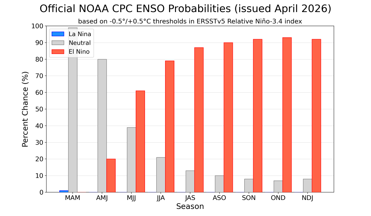
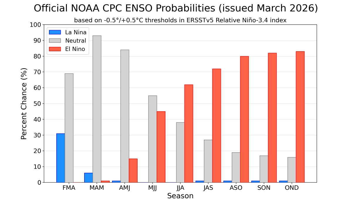
A transition from La Niña to ENSO-neutral is expected in the next month, with #ENSO-neutral favored through MJJ 2026 (55% chance). El Niño is likely to emerge In JJA 2026 (62% chance) and persist through at least the end of 2026. (1/2) https://t.co/5zlzaZ1aZx
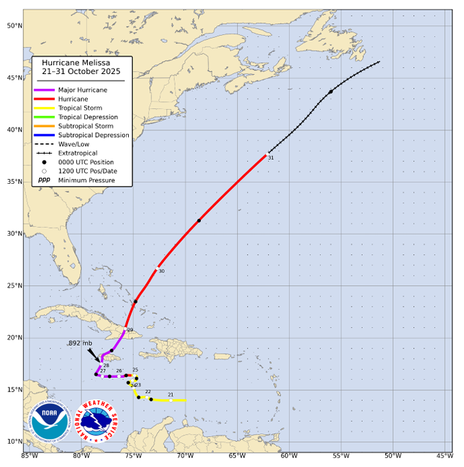
NHC has completed its post-analysis and Tropical Cyclone Report for Hurricane #Melissa.
Melissa, one of the strongest hurricanes on record in the Atlantic basin, reached category 5 intensity (on the Saffir-Simpson Hurricane Wind Scale) with a minimum central pressure of 892 mb and brought catastrophic wind and storm surge impacts to portions of western Jamaica. Melissa’s slow motion also produced heavy rainfall and catastrophic flood impacts across portions of the Greater Antilles. As of the release of the report, Melissa is responsible for 95 fatalities.
The report is available at https://t.co/ysyBlHTvYC
All reports for the 2025 Atlantic hurricane season can be found at https://t.co/c52ijljbXV
ITC #Gezani's RI continues unabated, with the storm likely now at ~Cat 4 intensity (~115-120KT/~130-140mph), with landfall imminent within the next few hours. This would make it one of the strongest landfalls in Madagascar in recent history.
NHC has completed its post-analysis and Tropical Cyclone Report for Hurricane #Erin (August 11-22, 2025). Erin was a large and long-lived hurricane that reached category 5 intensity. It brought flooding rain impacts to a portion of the Cabo Verde Islands, and wave and rip current impacts along a large stretch of the Atlantic coastline, together causing 13 direct deaths.
The report is available at: https://t.co/MfSAnl2xaN
Big addition: I've added the HAFS models to the lineup! Hurricane models have been sorely missing for a while, but now you can get a closer look at any storm the models run on including parameters you don't see on global models like simulated microwave imagery!
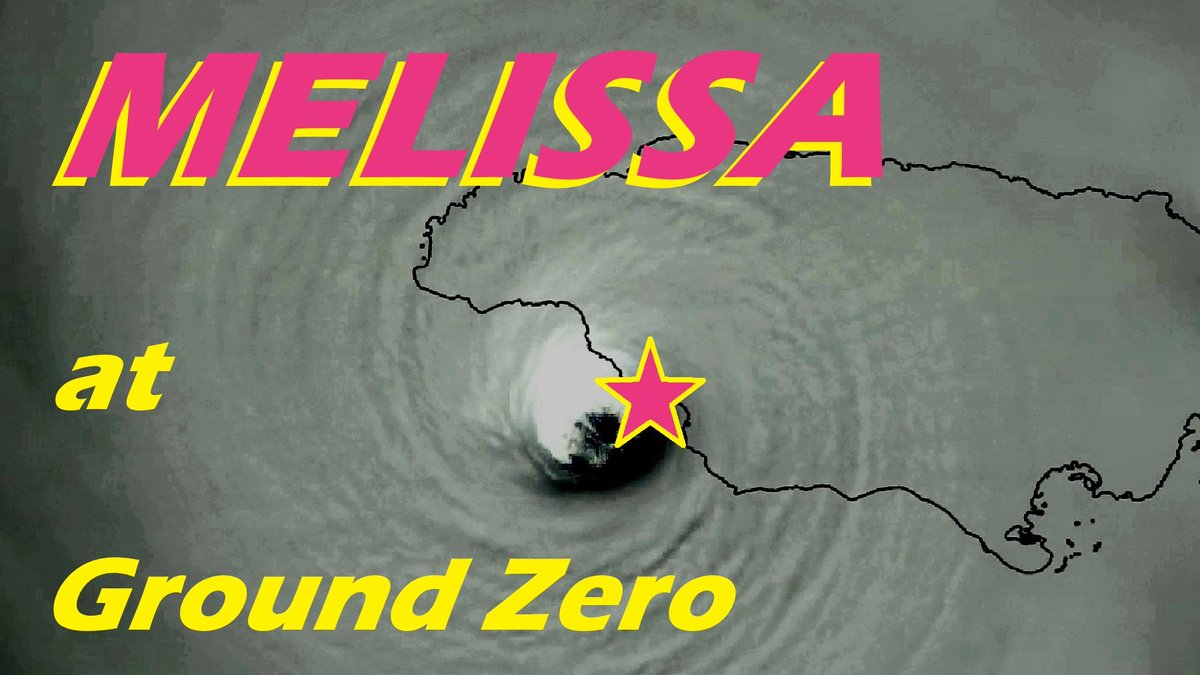
Finally, my video: Hurricane MELISSA at Ground Zero.
#MELISSA was the most epic chase of my career—and the most intense #hurricane I’ve witnessed. So, I gave it the grand, full-length documentary treatment. I was on the island of #Jamaica for 10 days, and this video brings you with me through that whole odyssey—getting to the island, slowly closing in on my prey, nailing the core of this nuclear-grade Category 5, and then many days living in the aftermath. Instead of just doing highlights, I wanted to make something complete—something that has chase strategy (for chaserdudes), minute-by-minute footage of the storm’s progress (for meteorologists to analyze), high-octane eyewall footage (for adrenaline junkies), survivors’ tales (for those who want the personal angle), and extensive documentation of the aftermath in multiple towns (for those interested in societal impacts).
But, most of all, I hope this video serve as a useful historical document for Jamaicans—an up-close and detailed record of this truly cataclysmic event in their nation’s history.
Regarding MELISSA’s winds… I feel convinced these are the highest winds I’ve personally witnessed or filmed—or heard. (The screaming sound as the storm peaked was harsh and painful, driving the people with me to hold their ears.) Big shoutout to the tall, hearty palm in front of the hotel. It served as a wind meter, showing its relative speed and direction. Without that tree, the eyewall footage would have just looked like dense clouds blowing past an airplane window. That tree shows the POWER—the way it bends in the really big, scary gusts. Eventually, though, things get so crazy you can’t even see the tree—it just disappears into the screaming white void. These winds were truly fierce. They even took down concrete buildings—obliterating the entire second floor of the concrete building across the street from my hotel. God knows what velocities some of those especially screamy gusts reached—but I’m grateful I was in a solid structure with thick walls.
So… If you want to come on a tough chase with a veteran chaserdude, sit back and enjoy this video from the beginning. If you just want to see the storm, start at Chapter 4: The Approach. And if you want to cut straight to the chocolate cake without eating your dinner (like a child), go right to Chapter 5: The Cataclysm. That’s the eyewall.
There you have it. Video link in the comments!
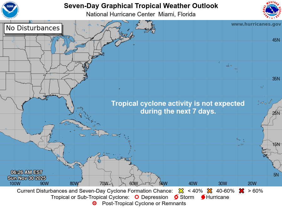
11/30: Today is the last day of the 2025 hurricane season. The month of November has proven to be very quiet this year, with no named storms during the month. There weren't even any disturbances mentioned in the Tropical Weather Outlook the entire month.
See https://t.co/Wq6ZtKfHp9
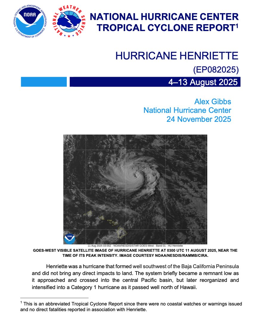
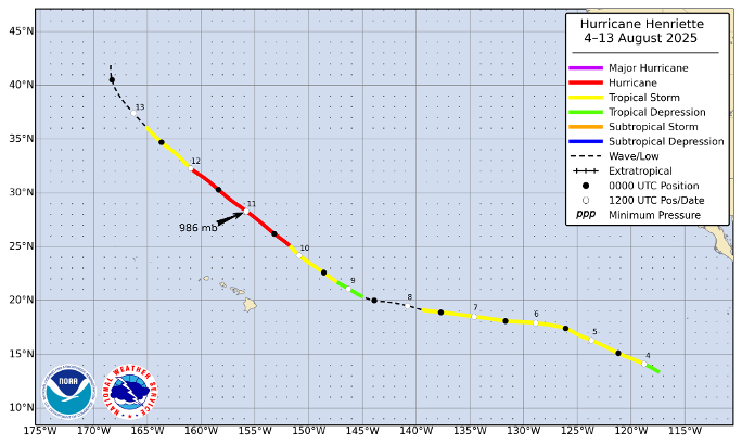
NHC has completed the post-analysis and Tropical Cyclone Report for Hurricane #Henriette (August 4-13, 2025). Henriette formed in the eastern Pacific basin and passed well north of the Hawaiian Islands as a category 1 hurricane with no impacts to Hawaii.
https://t.co/leNo2lRf3A
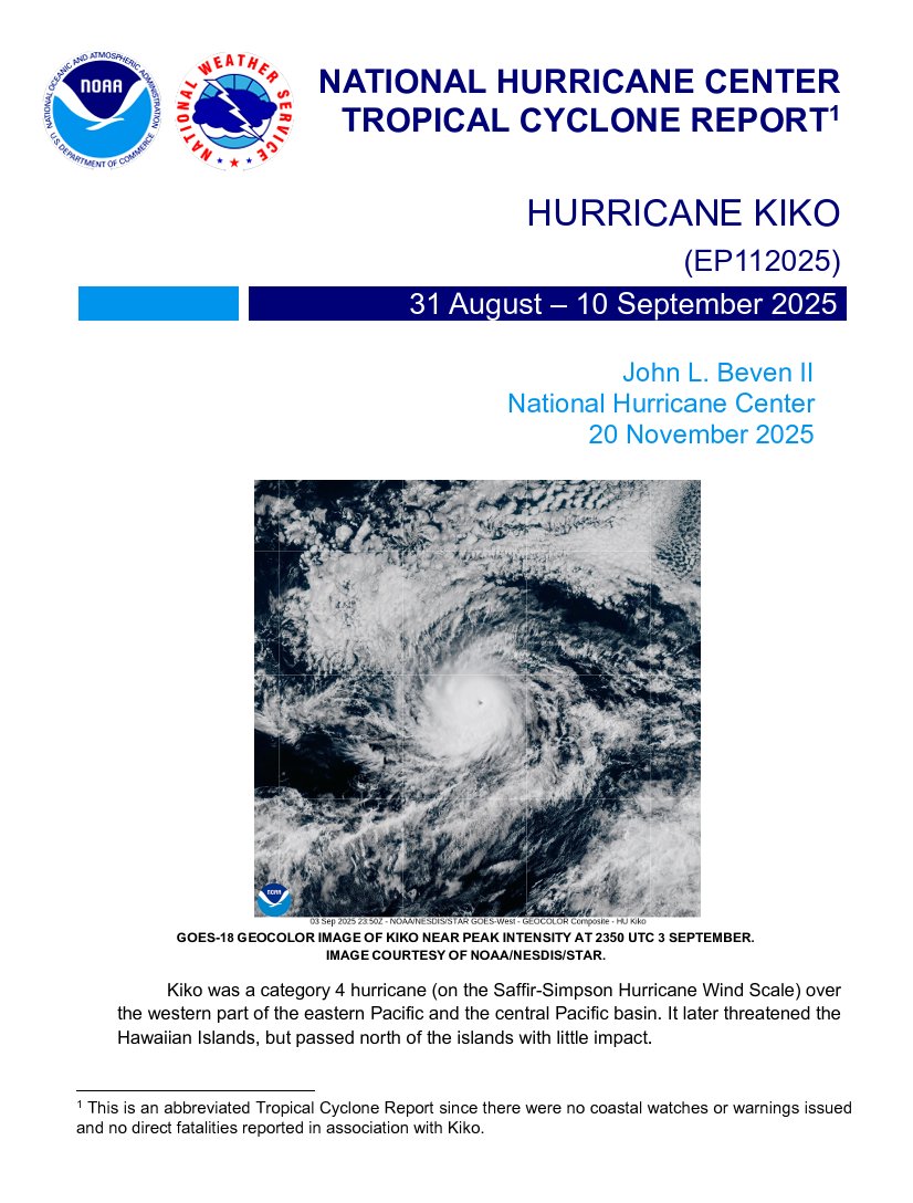
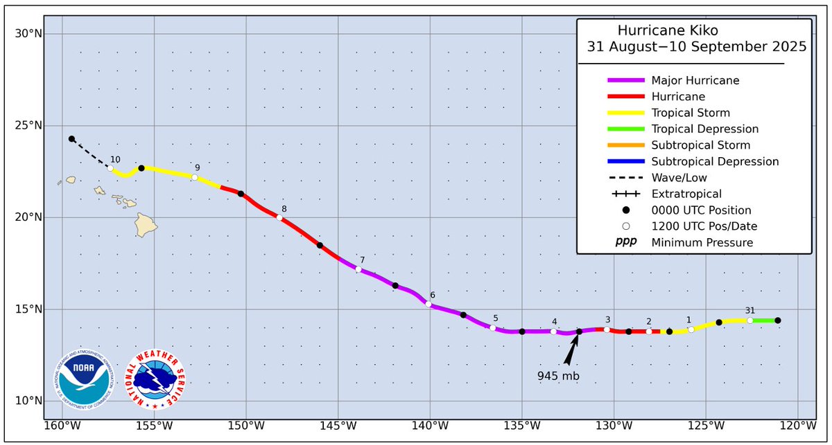
NHC has completed the post-analysis and Tropical Cyclone Report for Hurricane #Kiko (August 31-September 10, 2025). Kiko passed north of the Hawaiian Islands as a tropical storm with little impact.
The report is available at https://t.co/CpGHyR2e56